TopoQuest Logo
Do you find TopoQuest useful?
Help keep TopoQuest running and adding new maps/features by donating!
Bitcoin:  19c7KJd3qBynnjoSw5npx9KScwjBe4ifkT
Litecoin:  LXs6TkuXGGXo1vDsWCkWVdjQX94eUKd6ui
Home View Maps Find Maps Find Places Resources & Links


Clark Fork, Idaho Topographic Map

USGS Map Title: Clark Fork, ID
USGS Map MRC: 48116B2
DRG (GeoTIFF) Download: o48116b2.tif


Neighboring USGS Topographic Map Quads:


  Trout Peak, ID  
48116C3
 

  Trestle Peak, ID  
48116C2
 

  Benning Mountain, ID  
48116C1
 

  Hope, ID  
48116B3
 

  Clark Fork, ID  
48116B2
 

  Scotchman Peak, ID  
48116B1
 

  Packsaddle Mountain, ID  
48116A3
 

  Derr Point, ID  
48116A2
 

  Cabinet, ID  
48116A1


Map MRC Location:

N49°
W117°
N49°
W116°
H8 H7 H6 H5 H4 H3 H2 H1
G8 G7 G6 G5 G4 G3 G2 G1
F8 F7 F6 F5 F4 F3 F2 F1
E8 E7 E6 E5 E4 E3 E2 E1
D8 D7 D6 D5 D4 D3 D2 D1
C8 C7 C6 C5 C4 C3 C2 C1
B8 B7 B6 B5 B4 B3 B2 B1
A8 A7 A6 A5 A4 A3 A2 A1
N48°
W117°
N48°
W116°

Clark Fork, ID USGS 1:24K Topographic Map Preview:
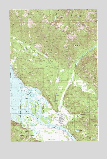
Clark Fork, ID USGS Topographic Map
Click on map above to begin viewing in our Map Viewer.

This topographic map contains these locations and features:
Feature Name Type Latitude Longitude GNIS ID View Map
Alpine TrailTrailN48.2233°W116.1755°376577View Map
Antelope LakeLakeN48.1349°W116.1554°376654View Map
Antelope MountainSummitN48.1405°W116.1332°376656View Map
Becker DrawValleyN48.2052°W116.1913°398559View Map
Bee Top MountainSummitN48.2352°W116.1479°396096View Map
Cascade CreekStreamN48.1827°W116.1666°378974View Map
City of Clark ForkCivilN48.1472°W116.1768°2409468View Map
Clark ForkPopulated PlaceN48.1452°W116.1757°396290View Map
Clark Fork Ambulance ServiceBuildingN48.1453°W116.1787°2642780View Map
Clark Fork DivisionCivilN48.1685°W116.2358°1936691View Map
Clark Fork Fish HatcheryLocaleN48.1694°W116.1841°401238View Map
Clark Fork Junior - Senior High SchoolSchoolN48.1468°W116.1756°401273View Map
Clark Fork Post OfficePost OfficeN48.1456°W116.1784°2766806View Map
Clark Fork Ranger Station (historical)LocaleN48.1497°W116.1532°379367View Map
Clark Fork Valley Fire DepartmentBuildingN48.1484°W116.1757°2619064View Map
Cougar CreekStreamN48.2041°W116.2416°379886View Map
Cougar PeakSummitN48.2449°W116.2207°400343View Map
CX Ranch AirportAirportN48.1382°W116.1983°400787View Map
CX Ranch Number 2 AirportAirportN48.1427°W116.1833°2443802View Map
Delta Shores AirportAirportN48.1452°W116.2168°2443801View Map
DentonPopulated PlaceN48.2027°W116.2482°399476View Map
Derr CreekStreamN48.1366°W116.2255°380519View Map
Derr IslandIslandN48.1460°W116.2257°380520View Map
Hope MineMineN48.1672°W116.1732°383322View Map
Howe MountainSummitN48.1902°W116.2196°396675View Map
Idaho State Fish HatcheryLocaleN48.1699°W116.1838°394232View Map
Johnson CreekStreamN48.1383°W116.2310°383979View Map
Lawrence MineMineN48.1477°W116.1507°384490View Map
Lightning CreekStreamN48.1405°W116.1916°384638View Map
Middle Fork Clark ForkStreamN48.1552°W116.2482°386803View Map
Mosquito CreekStreamN48.1388°W116.1791°387264View Map
Panhandle Wildlife Management AreaParkN48.1438°W116.2060°394329View Map
Pole CreekStreamN48.1310°W116.2255°400387View Map
Porcupine LakeLakeN48.2421°W116.1848°388762View Map
Porcupine Lake CampgroundLocaleN48.2438°W116.1855°394239View Map
Riverlake AirportAirportN48.1256°W116.1653°2443803View Map
South Fork Clark ForkStreamN48.1419°W116.2057°390906View Map
Spring CreekStreamN48.1572°W116.1827°391183View Map
Still LakeLakeN48.2434°W116.1516°391460View Map
University of Idaho Clark Fork Field CampusSchoolN48.1497°W116.1532°393822View Map
Webb CanyonValleyN48.1791°W116.1349°400398View Map
Whitedelf MineMineN48.1638°W116.1868°393379View Map

Note: Coordinates in the location and feature list above are referenced to NAD83 datum.


Copyright (C) 2008-2024 Ryan Niemi / Sunset Dynamics ... All Rights Reserved