TopoQuest Logo
Do you find TopoQuest useful?
Help keep TopoQuest running and adding new maps/features by donating!
Bitcoin:  19c7KJd3qBynnjoSw5npx9KScwjBe4ifkT
Litecoin:  LXs6TkuXGGXo1vDsWCkWVdjQX94eUKd6ui
Home View Maps Find Maps Find Places Resources & Links


Shallotte, North Carolina Topographic Map

USGS Map Title: Shallotte, NC
USGS Map MRC: 33078H4
DRG (GeoTIFF) Download: o33078h4.tif


Neighboring USGS Topographic Map Quads:


  Freeland, NC  
34078A5
 

  Exum, NC  
34078A4
 

  Supply, NC  
34078A3
 

  Calabash, NC  
33078H5
 

  Shallotte, NC  
33078H4
 

  Holden Beach, NC  
33078H3
 

  Little River, SC  
33078G5


Map MRC Location:

N34°
W79°
N34°
W78°
H8 H7 H6 H5 H4 H3 H2 H1
G8 G7 G6 G5 G4 G3 G2 G1
F8 F7 F6 F5 F4 F3 F2 F1
E8 E7 E6 E5 E4 E3 E2 E1
D8 D7 D6 D5 D4 D3 D2 D1
C8 C7 C6 C5 C4 C3 C2 C1
B8 B7 B6 B5 B4 B3 B2 B1
A8 A7 A6 A5 A4 A3 A2 A1
N33°
W79°
N33°
W78°

Shallotte, NC USGS 1:24K Topographic Map Preview:
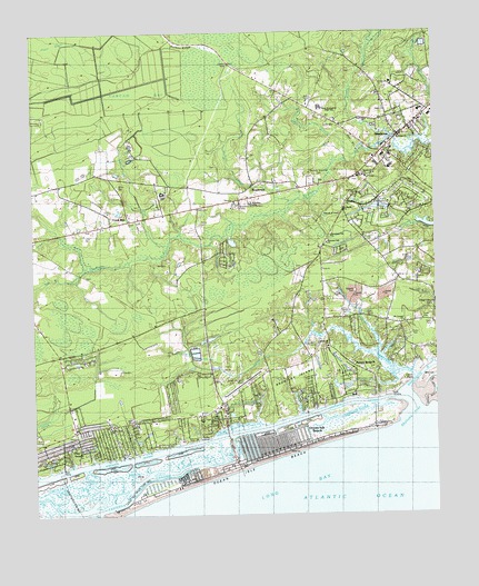
Shallotte, NC USGS Topographic Map
Click on map above to begin viewing in our Map Viewer.

This topographic map contains these locations and features:
Feature Name Type Latitude Longitude GNIS ID View Map
Abundant Life ChurchChurchN33.9468°W78.4144°1004776View Map
Apricot CreekGutN33.8921°W78.4383°980264View Map
Big Gut SloughStreamN33.9013°W78.4172°981400View Map
Brantley IslandIslandN33.9116°W78.4147°981837View Map
Brick LandingPopulated PlaceN33.9049°W78.3919°1019292View Map
Brick Landing PlantationPopulated PlaceN33.9106°W78.4040°1005421View Map
Brooks CemeteryCemeteryN33.9507°W78.4475°1004772View Map
Brunswick County Library - Rourk BranchBuildingN33.9611°W78.4073°2506327View Map
Brunswick County Regional Emergency Services Training and Operating Facility HeadquartersBuildingN33.9616°W78.4144°2720414View Map
Brunswick County SchoolSchoolN33.9666°W78.3892°982047View Map
Brunswick Memorial GardensCemeteryN33.9549°W78.4358°1004783View Map
Calvary ChurchChurchN33.9579°W78.3992°1004786View Map
Calvin PointCapeN33.9096°W78.3839°982469View Map
Camp ChurchChurchN33.9727°W78.3856°1004766View Map
Cawcaw BaySwampN33.9868°W78.4650°982782View Map
Clam CreekGutN33.8874°W78.4656°983206View Map
Cool RunPopulated PlaceN33.9516°W78.4700°1019765View Map
Cool RunStreamN33.9446°W78.4581°983484View Map
Cooter CreekGutN33.8824°W78.4925°983519View Map
Eastern ChannelChannelN33.8846°W78.4656°984550View Map
Gause LandingLocaleN33.8949°W78.4472°1020406View Map
Gause Landing CreekGutN33.8988°W78.4361°1006109View Map
Gold Mine CreekLakeN33.8888°W78.4652°985775View Map
Goose CreekStreamN33.9093°W78.3875°985816View Map
Grace ChurchChurchN33.9799°W78.3897°1004778View Map
Gurganus CemeteryCemeteryN33.9366°W78.3817°986266View Map
Head o' BaySwampN33.9974°W78.4728°986561View Map
Horse Ford CreekGutN33.8846°W78.4736°987096View Map
Hutson RidgeRidgeN33.9963°W78.4522°987297View Map
Jennies BranchStreamN33.9217°W78.4136°987614View Map
Jennies Branch Baptist ChurchChurchN33.9185°W78.4083°987615View Map
Jinks CreekLakeN33.8785°W78.4930°987613View Map
Jinnys Branch (historical)Populated PlaceN33.9132°W78.3992°1020955View Map
Kilbart SloughStreamN33.8996°W78.4306°987951View Map
Lions Paw Golf LinksLocaleN33.9378°W78.4895°2490028View Map
Little Sauce Pan CreekStreamN33.9171°W78.3933°988769View Map
Lookout BranchStreamN33.9682°W78.3981°1004785View Map
McMilly SwampStreamN33.9538°W78.4219°989626View Map
Mintz CemeteryCemeteryN33.9602°W78.4733°990065View Map
Monks IslandIslandN33.9107°W78.3781°990143View Map
Mount Carmel ChurchChurchN33.9274°W78.3844°1004774View Map
Mulberry BranchStreamN33.9727°W78.3875°990771View Map
Needham Hole CreekGutN33.8905°W78.4478°990893View Map
New Hope ChurchChurchN33.8999°W78.4608°990987View Map
Ocean Isle BeachPopulated PlaceN33.8943°W78.4267°1004781View Map
Ocean Isle BeachBeachN33.8863°W78.4372°1004782View Map
Ocean Isle Beach Fire DepartmentBuildingN33.8999°W78.4400°2638386View Map
Ocean Isle Beach Police DepartmentBuildingN33.8890°W78.4379°2130960View Map
Ocean Isle Beach Post Office (historical)Post OfficeN33.8943°W78.4267°1940255View Map
Ocean View ChurchChurchN33.8982°W78.4767°1004768View Map
Odell Williamson Municipal AirportAirportN33.9068°W78.4374°997841View Map
Old Mill CreekStreamN33.9166°W78.3914°991582View Map
Pelican Pointe MarinaHarborN33.8905°W78.4729°2506056View Map
Piver BaysSwampN33.9993°W78.4933°992436View Map
Pleasant Hill ChurchChurchN33.9454°W78.4081°1004775View Map
Pleasant Hill ChurchChurchN33.9460°W78.4083°1024905View Map
Register CemeteryCemeteryN33.9329°W78.4000°993227View Map
RusstownPopulated PlaceN33.9574°W78.4314°1022448View Map
Saint Brendian MissionChurchN33.9549°W78.4320°1004779View Map
Saint James ChurchChurchN33.9691°W78.3897°1004767View Map
Saint Marks ChurchChurchN33.9538°W78.4028°994008View Map
Sauce Pan CreekStreamN33.9105°W78.3816°994367View Map
Saw Pit SwampStreamN33.9399°W78.4820°994386View Map
Sea Trail PlantationPopulated PlaceN33.9002°W78.4995°1005422View Map
SeasidePopulated PlaceN33.8896°W78.4853°1022532View Map
ShallottePopulated PlaceN33.9732°W78.3858°1004830View Map
Shallotte ChurchChurchN33.9629°W78.3961°1004770View Map
Shallotte Fire Department Station 1BuildingN33.9743°W78.3811°2638399View Map
Shallotte Fire Department Station 2BuildingN33.9869°W78.4263°2639049View Map
Shallotte Fire Department Station 3BuildingN33.9612°W78.4164°2639059View Map
Shallotte InletChannelN33.9043°W78.3811°994567View Map
Shallotte Lookout TowerTowerN33.9918°W78.4383°1023689View Map
Shallotte Point Volunteer Fire DepartmentBuildingN33.9255°W78.3788°2638918View Map
Shallotte Police DepartmentBuildingN33.9748°W78.3812°2130975View Map
Shallotte Post OfficePost OfficeN33.9822°W78.3793°2774058View Map
Shallotte Rescue SquadBuildingN33.9813°W78.3778°2720495View Map
Shallotte RiverStreamN33.9088°W78.3826°994568View Map
Shallotte SoundBayN33.9018°W78.3994°994569View Map
Shallotte Township ParkParkN33.9618°W78.4108°1004771View Map
Shepherd ChurchChurchN33.9607°W78.4933°1004769View Map
Sols CreekGutN33.8860°W78.4697°995105View Map
Sols IslandIslandN33.8855°W78.4675°995109View Map
South Brunswick Post OfficePost OfficeN33.9017°W78.4878°2773859View Map
Spring BranchGutN33.8891°W78.4547°995316View Map
Still CreekGutN33.8843°W78.4822°995512View Map
Summerhomes Mobile Home ParkPopulated PlaceN33.9306°W78.4099°2505666View Map
Sunset Beach Police DepartmentBuildingN33.8938°W78.4969°2130835View Map
Town of Ocean Isle BeachCivilN33.9008°W78.4379°2407032View Map
Town of ShallotteCivilN33.9753°W78.3807°2407319View Map
Township of ShallotteCivilN33.9217°W78.4933°1026438View Map
Tubbs InletGutN33.8760°W78.4817°1004784View Map
Union SchoolSchoolN33.9585°W78.4592°1004777View Map
Village Point ChurchChurchN33.9293°W78.3750°1024906View Map
WDZD-FM (Shallotte)TowerN33.9263°W78.3964°1018610View Map
West Brunswick High SchoolSchoolN33.9796°W78.4098°1004780View Map
Woodward BranchStreamN33.9713°W78.3781°997621View Map
WVCB-AM (Shallotte)TowerN33.9724°W78.3836°1018351View Map

Note: Coordinates in the location and feature list above are referenced to NAD83 datum.


Copyright (C) 2008-2024 Ryan Niemi / Sunset Dynamics ... All Rights Reserved