TopoQuest Logo
Do you find TopoQuest useful?
Help keep TopoQuest running and adding new maps/features by donating!
Bitcoin:  19c7KJd3qBynnjoSw5npx9KScwjBe4ifkT
Litecoin:  LXs6TkuXGGXo1vDsWCkWVdjQX94eUKd6ui
Home View Maps Find Maps Find Places Resources & Links


Rock Mountain, Georgia Topographic Map

USGS Map Title: Rock Mountain, GA
USGS Map MRC: 34085C3
DRG (GeoTIFF) Download: o34085c3.tif


Neighboring USGS Topographic Map Quads:


  Lyerly, GA  
34085D4
 

  Summerville, GA  
34085D3
 

  Armuchee, GA  
34085D2
 

  Chattoogaville, GA  
34085C4
 

  Rock Mountain, GA  
34085C3
 

  Rome North, GA  
34085C2
 

  Melson, GA  
34085B4
 

  Livingston, GA  
34085B3
 

  Rome South, GA  
34085B2


Map MRC Location:

N35°
W86°
N35°
W85°
H8 H7 H6 H5 H4 H3 H2 H1
G8 G7 G6 G5 G4 G3 G2 G1
F8 F7 F6 F5 F4 F3 F2 F1
E8 E7 E6 E5 E4 E3 E2 E1
D8 D7 D6 D5 D4 D3 D2 D1
C8 C7 C6 C5 C4 C3 C2 C1
B8 B7 B6 B5 B4 B3 B2 B1
A8 A7 A6 A5 A4 A3 A2 A1
N34°
W86°
N34°
W85°

Rock Mountain, GA USGS 1:24K Topographic Map Preview:
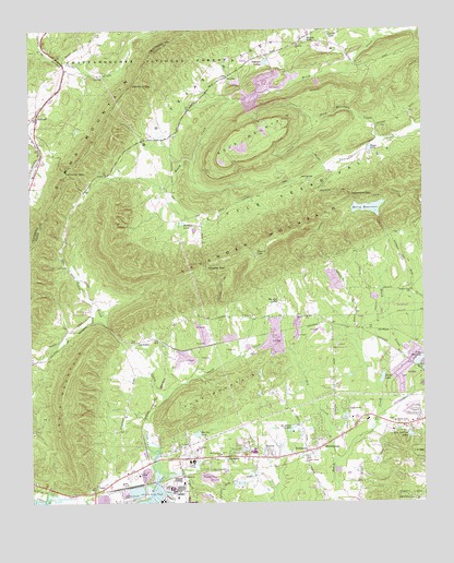
Rock Mountain, GA USGS Topographic Map
Click on map above to begin viewing in our Map Viewer.

This topographic map contains these locations and features:
Feature Name Type Latitude Longitude GNIS ID View Map
Antioch CemeteryCemeteryN34.3715°W85.2888°353520View Map
Antioch ChurchChurchN34.3709°W85.2891°354368View Map
Beard SpringSpringN34.3348°W85.3297°353532View Map
Beech Creek CemeteryCemeteryN34.2715°W85.2594°353533View Map
Beech Creek ChurchChurchN34.2712°W85.2591°354526View Map
Beech Creek HomesPopulated PlaceN34.2737°W85.2533°353534View Map
BentonPopulated PlaceN34.2620°W85.2983°327072View Map
Berry ReservoirReservoirN34.3277°W85.2670°327080View Map
Berry Reservoir DamDamN34.3256°W85.2638°337066View Map
BerryhillPopulated PlaceN34.2959°W85.2694°353541View Map
Boggs LakeLakeN34.3435°W85.2667°327193View Map
BonePopulated PlaceN34.2912°W85.3305°353547View Map
Butler CemeteryCemeteryN34.2520°W85.3622°353556View Map
Cabin CreekStreamN34.2506°W85.3380°327316View Map
Cave Spring CemeteryCemeteryN34.2956°W85.3277°312440View Map
Chubb ChapelChurchN34.3423°W85.2827°355163View Map
CoosaPopulated PlaceN34.2545°W85.3544°355297View Map
Coosa High SchoolSchoolN34.2633°W85.3044°353596View Map
Coosa Middle SchoolSchoolN34.2685°W85.3047°2545568View Map
Coosa Post OfficePost OfficeN34.2629°W85.2916°353597View Map
Coosa SchoolsSchoolN34.2612°W85.3241°355301View Map
Cordle LakeReservoirN34.3735°W85.2794°327525View Map
Dry CreekStreamN34.2604°W85.2788°327689View Map
Evergreen School (historical)SchoolN34.3531°W85.3238°353642View Map
FouchePopulated PlaceN34.3623°W85.3119°331759View Map
Fouche GapGapN34.3118°W85.3186°327868View Map
Funderburk CreekStreamN34.2506°W85.2786°327904View Map
Glovers LakeLakeN34.3154°W85.3030°327948View Map
Hardin LakeLakeN34.3023°W85.2965°328060View Map
Henricks GapGapN34.3604°W85.3416°328108View Map
Hicks LakeLakeN34.2827°W85.2632°328141View Map
HollandPopulated PlaceN34.3520°W85.3725°328195View Map
Holland Volunteer Fire DepartmentBuildingN34.3521°W85.3729°2604333View Map
Jo-Anns LakesLakeN34.2690°W85.2931°328325View Map
Judy MountainSummitN34.2773°W85.3188°332123View Map
Kitchen GapGapN34.3370°W85.3633°328417View Map
KrannertPopulated PlaceN34.2573°W85.3275°332161View Map
Krannert SchoolSchoolN34.2640°W85.3227°328423View Map
Lake JulianneLakeN34.2873°W85.2512°328366View Map
LakeviewPopulated PlaceN34.2745°W85.2750°332170View Map
Lakeview Baptist ChurchChurchN34.2723°W85.2730°353732View Map
LavenderPopulated PlaceN34.2920°W85.3411°328452View Map
Little Creek ChurchChurchN34.2606°W85.2880°328540View Map
Martin LakeReservoirN34.2682°W85.3224°328712View Map
Mathis LakeLakeN34.3723°W85.2866°328727View Map
Meadow LakeReservoirN34.2654°W85.3022°328753View Map
MorningsidePopulated PlaceN34.2645°W85.2825°332420View Map
Mount Alto CemeteryCemeteryN34.2990°W85.2883°353768View Map
Mount Alto ChurchChurchN34.2990°W85.2880°328866View Map
Mount Pleasant CemeteryCemeteryN34.2631°W85.3150°353777View Map
Mount Pleasant ChurchChurchN34.2626°W85.3150°328889View Map
OreburgPopulated PlaceN34.2620°W85.3127°329101View Map
Padlock CemeteryCemeteryN34.2737°W85.3219°320154View Map
Peacock LakeLakeN34.3239°W85.3266°329153View Map
Pisgah CemeteryCemeteryN34.2576°W85.3422°353825View Map
Pisgah ChurchChurchN34.2573°W85.3411°329244View Map
Possum Trot CemeteryCemeteryN34.3065°W85.2541°353831View Map
Possum Trot ChurchChurchN34.3062°W85.2538°353832View Map
Possum Trot SchoolSchoolN34.3059°W85.2538°329309View Map
Redmond GapGapN34.3315°W85.2727°329386View Map
Rice Spring FarmLocaleN34.2706°W85.2636°353840View Map
Rice Springs EstatesPopulated PlaceN34.2668°W85.2527°353841View Map
Rice Springs LakeReservoirN34.2680°W85.2547°329414View Map
Rices SpringSpringN34.2679°W85.2547°353842View Map
RobinsonPopulated PlaceN34.2634°W85.2875°332876View Map
Rock MountainSummitN34.3462°W85.3063°332881View Map
Rock Mountain CreekStreamN34.3470°W85.2588°329468View Map
RollingwoodPopulated PlaceN34.2873°W85.2544°353855View Map
Rome - Floyd County Fire Department Station 7BuildingN34.2693°W85.2785°2604070View Map
Rowell Siding (historical)LocaleN34.3723°W85.3708°344483View Map
Sand SpringSpringN34.3418°W85.2708°353869View Map
Sand Springs CemeteryCemeteryN34.3345°W85.2863°353871View Map
Sand Springs ChurchChurchN34.3348°W85.2858°329587View Map
Selman LakesLakeN34.3674°W85.2954°329640View Map
Smith CreekStreamN34.2779°W85.3322°329736View Map
Turnip MountainRidgeN34.2776°W85.3650°330084View Map
Williamsburg EstatesPopulated PlaceN34.2931°W85.2675°353940View Map

Note: Coordinates in the location and feature list above are referenced to NAD83 datum.


Copyright (C) 2008-2024 Ryan Niemi / Sunset Dynamics ... All Rights Reserved