TopoQuest Logo
Do you find TopoQuest useful?
Help keep TopoQuest running and adding new maps/features by donating!
Bitcoin:  19c7KJd3qBynnjoSw5npx9KScwjBe4ifkT
Litecoin:  LXs6TkuXGGXo1vDsWCkWVdjQX94eUKd6ui
Home View Maps Find Maps Find Places Resources & Links


Pavillion, Wyoming Topographic Map

USGS Map Title: Pavillion, WY
USGS Map MRC: 43108B6
DRG (GeoTIFF) Download: o43108b6.tif


Neighboring USGS Topographic Map Quads:


  Lookout Butte, WY  
43108C7
 

  Pavillion Butte, WY  
43108C6
 

  Harris Bridge, WY  
43108C5
 

  Morton, WY  
43108B7
 

  Pavillion, WY  
43108B6
 

  Ocean Lake, WY  
43108B5
 

  Ethete, WY  
43108A7
 

  Mule Butte, WY  
43108A6
 

  Pavillion SE, WY  
43108A5


Map MRC Location:

N44°
W109°
N44°
W108°
H8 H7 H6 H5 H4 H3 H2 H1
G8 G7 G6 G5 G4 G3 G2 G1
F8 F7 F6 F5 F4 F3 F2 F1
E8 E7 E6 E5 E4 E3 E2 E1
D8 D7 D6 D5 D4 D3 D2 D1
C8 C7 C6 C5 C4 C3 C2 C1
B8 B7 B6 B5 B4 B3 B2 B1
A8 A7 A6 A5 A4 A3 A2 A1
N43°
W109°
N43°
W108°

Pavillion, WY USGS 1:24K Topographic Map Preview:
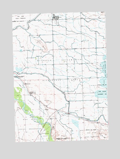
Pavillion, WY USGS Topographic Map
Click on map above to begin viewing in our Map Viewer.

This topographic map contains these locations and features:
Feature Name Type Latitude Longitude GNIS ID View Map
Aragon CemeteryCemeteryN43.1564°W108.7074°1584912View Map
Big RidgeRidgeN43.1263°W108.6290°1585497View Map
Fremont County Fire Protection District Battalion 5 Morton - KinnearBuildingN43.1511°W108.6771°2673524View Map
Fremont County Fire Protection District Battalion 7 PavillionBuildingN43.2437°W108.6955°2673526View Map
Grave of N B KinnearCemeteryN43.1733°W108.7292°1589076View Map
KinnearPopulated PlaceN43.1519°W108.6776°1590366View Map
Kinnear Post OfficePost OfficeN43.1514°W108.6781°2768539View Map
Kinnear ValleyValleyN43.1405°W108.7023°1590368View Map
Morton SchoolSchoolN43.1816°W108.7343°1591779View Map
PavillionPopulated PlaceN43.2447°W108.6901°1592630View Map
Pavillion Post OfficePost OfficeN43.2453°W108.6909°2767835View Map
Pilot DrainCanalN43.1891°W108.6857°1592756View Map
Saint Edwards ChurchChurchN43.1730°W108.7293°1593779View Map
Sand ButteSummitN43.2194°W108.7115°1596892View Map
Sand Butte LateralCanalN43.2258°W108.7121°1593828View Map
Sunnyside ChurchChurchN43.1441°W108.6509°1595208View Map
Sunnyside DrainCanalN43.1541°W108.6634°1595209View Map
Town of PavillionCivilN43.2440°W108.6890°2413119View Map
Wind River High SchoolSchoolN43.2447°W108.6901°1795491View Map
Wind River Middle SchoolSchoolN43.2447°W108.6901°1795493View Map
Wind River SchoolSchoolN43.2447°W108.6901°1795494View Map
Wyoming CanalCanalN43.2391°W108.7290°1596651View Map

Note: Coordinates in the location and feature list above are referenced to NAD83 datum.


Copyright (C) 2008-2024 Ryan Niemi / Sunset Dynamics ... All Rights Reserved