TopoQuest Logo
Do you find TopoQuest useful?
Help keep TopoQuest running and adding new maps/features by donating!
Bitcoin:  19c7KJd3qBynnjoSw5npx9KScwjBe4ifkT
Litecoin:  LXs6TkuXGGXo1vDsWCkWVdjQX94eUKd6ui
Home View Maps Find Maps Find Places Resources & Links


Old Snowy Mountain, Washington Topographic Map

USGS Map Title: Old Snowy Mountain, WA
USGS Map MRC: 46121E4
DRG (GeoTIFF) Download: o46121e4.tif


Neighboring USGS Topographic Map Quads:


  Ohanapecosh Hot Springs, WA  
46121F5
 

  White Pass, WA  
46121F4
 

  Spiral Butte, WA  
46121F3
 

  Packwood Lake, WA  
46121E5
 

  Old Snowy Mountain, WA  
46121E4
 

  Pinegrass Ridge, WA  
46121E3
 

  Hamilton Buttes, WA  
46121D5
 

  Walupt Lake, WA  
46121D4
 

  Jennies Butte, WA  
46121D3


Map MRC Location:

N47°
W122°
N47°
W121°
H8 H7 H6 H5 H4 H3 H2 H1
G8 G7 G6 G5 G4 G3 G2 G1
F8 F7 F6 F5 F4 F3 F2 F1
E8 E7 E6 E5 E4 E3 E2 E1
D8 D7 D6 D5 D4 D3 D2 D1
C8 C7 C6 C5 C4 C3 C2 C1
B8 B7 B6 B5 B4 B3 B2 B1
A8 A7 A6 A5 A4 A3 A2 A1
N46°
W122°
N46°
W121°

Old Snowy Mountain, WA USGS 1:24K Topographic Map Preview:
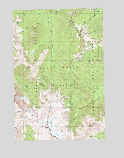
Old Snowy Mountain, WA USGS Topographic Map
Click on map above to begin viewing in our Map Viewer.

This topographic map contains these locations and features:
Feature Name Type Latitude Longitude GNIS ID View Map
Chimney CreekStreamN46.5965°W121.4484°1517713View Map
Chimney RockSummitN46.5696°W121.4793°1517716View Map
Clear Lost TrailTrailN46.6196°W121.4837°1517840View Map
Coyote CreekStreamN46.6154°W121.4518°1518243View Map
Coyote LakeLakeN46.6127°W121.4972°1518248View Map
Coyote TrailTrailN46.5482°W121.4651°1518257View Map
Dana Yelverton ShelterLocaleN46.5134°W121.4598°1529419View Map
Egg ButteSummitN46.5351°W121.4626°1519199View Map
Elk PassGapN46.5387°W121.4554°1519289View Map
Goat LakeLakeN46.5222°W121.4859°1520032View Map
Goat Rocks WildernessReserveN46.5369°W121.4486°1529479View Map
Hawkeye PointCapeN46.5226°W121.4926°1520612View Map
Hidden SpringSpringN46.5753°W121.3937°1520763View Map
Hogback MountainSummitN46.5998°W121.4056°1520836View Map
Hogback RidgeRidgeN46.6079°W121.4143°1520837View Map
Ives PeakSummitN46.5032°W121.4470°1521281View Map
Lily Basin TrailTrailN46.5171°W121.4745°1522094View Map
Lutz LakeLakeN46.5449°W121.4196°1522586View Map
McCall BasinBasinN46.5332°W121.4209°1522848View Map
McCall GlacierGlacierN46.5056°W121.4436°1522850View Map
Miriam LakeLakeN46.6008°W121.3980°1523258View Map
Old Snowy MountainSummitN46.5121°W121.4540°1524015View Map
Packwood GlacierGlacierN46.5165°W121.4604°1524133View Map
Packwood SaddleGapN46.5512°W121.4637°1524136View Map
Pigtail PeakSummitN46.6240°W121.3873°1528484View Map
Saddle CreekStreamN46.5518°W121.4893°1525328View Map
Shoe LakeLakeN46.5882°W121.3949°1525692View Map
Shoe Lake TrailTrailN46.5693°W121.3895°1525694View Map
Tieton PassGapN46.5534°W121.4192°1527203View Map
Tieton PeakSummitN46.5121°W121.3948°1527204View Map

Note: Coordinates in the location and feature list above are referenced to NAD83 datum.


Copyright (C) 2008-2024 Ryan Niemi / Sunset Dynamics ... All Rights Reserved