TopoQuest Logo
Do you find TopoQuest useful?
Help keep TopoQuest running and adding new maps/features by donating!
Bitcoin:  19c7KJd3qBynnjoSw5npx9KScwjBe4ifkT
Litecoin:  LXs6TkuXGGXo1vDsWCkWVdjQX94eUKd6ui
Home View Maps Find Maps Find Places Resources & Links


Nicholls, Georgia Topographic Map

USGS Map Title: Nicholls, GA
USGS Map MRC: 31082E6
DRG (GeoTIFF) Download: o31082e6.tif


Neighboring USGS Topographic Map Quads:


  Broxton NE, GA  
31082F7
 

  Denton, GA  
31082F6
 

  Nicholls NE, GA  
31082F5
 

  Douglas North, GA  
31082E7
 

  Nicholls, GA  
31082E6
 

  Sessoms, GA  
31082E5
 

  Douglas South, GA  
31082D7
 

  Wilsonville, GA  
31082D6
 

  Beach, GA  
31082D5


Map MRC Location:

N32°
W83°
N32°
W82°
H8 H7 H6 H5 H4 H3 H2 H1
G8 G7 G6 G5 G4 G3 G2 G1
F8 F7 F6 F5 F4 F3 F2 F1
E8 E7 E6 E5 E4 E3 E2 E1
D8 D7 D6 D5 D4 D3 D2 D1
C8 C7 C6 C5 C4 C3 C2 C1
B8 B7 B6 B5 B4 B3 B2 B1
A8 A7 A6 A5 A4 A3 A2 A1
N31°
W83°
N31°
W82°

Nicholls, GA USGS 1:24K Topographic Map Preview:
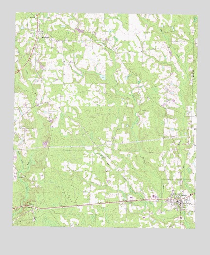
Nicholls, GA USGS Topographic Map
Click on map above to begin viewing in our Map Viewer.

This topographic map contains these locations and features:
Feature Name Type Latitude Longitude GNIS ID View Map
Bear CreekStreamN31.5080°W82.6521°310925View Map
ChattertonPopulated PlaceN31.5116°W82.7363°326218View Map
Chatterton CemeteryCemeteryN31.5035°W82.7354°344854View Map
Chatterton ChurchChurchN31.5038°W82.7354°355127View Map
City of NichollsCivilN31.5192°W82.6387°2404380View Map
Coffee Correctional FacilityBuildingN31.5314°W82.6372°2735692View Map
Coffee County Fire and Rescue Department Station 11BuildingN31.6115°W82.7355°2604318View Map
Coffee County Fire and Rescue Department Station 12BuildingN31.5213°W82.6346°2603863View Map
Coffee County Fire and Rescue Department Station 15BuildingN31.5079°W82.7360°2604672View Map
Hinson CemeteryCemeteryN31.6074°W82.6865°315453View Map
Holiness ChurchChurchN31.5105°W82.7488°345080View Map
Kirkland CemeteryCemeteryN31.5269°W82.7371°316472View Map
Lott CemeteryCemeteryN31.5688°W82.6621°317420View Map
NichollsPopulated PlaceN31.5174°W82.6349°356428View Map
Nicholls Elementary SchoolSchoolN31.5163°W82.6374°345098View Map
Nicholls High SchoolSchoolN31.5163°W82.6368°345099View Map
Nicholls Police DepartmentBuildingN31.5158°W82.6348°2734149View Map
Otter CreekStreamN31.5066°W82.7496°320115View Map
SaginawPopulated PlaceN31.5160°W82.6696°332953View Map
Saginaw Baptist ChurchChurchN31.5141°W82.6704°345120View Map
Sand Hill CemeteryCemeteryN31.5291°W82.7429°345130View Map
Sand Hill ChurchChurchN31.5288°W82.7424°322424View Map
Tiger CreekStreamN31.5319°W82.7443°324169View Map
Ward CemeteryCemeteryN31.6144°W82.7446°345145View Map
West GreenPopulated PlaceN31.6130°W82.7346°356628View Map
West Green Baptist ChurchChurchN31.6141°W82.7340°345147View Map
West Green DivisionCivilN31.6096°W82.7408°1936639View Map
West Green Elementary SchoolSchoolN31.6116°W82.7382°345148View Map
West Green United Methodist ChurchChurchN31.6132°W82.7354°345149View Map
Wilcox CemeteryCemeteryN31.5799°W82.6607°345153View Map
Wood-Spell CemeteryCemeteryN31.6019°W82.7121°345156View Map

Note: Coordinates in the location and feature list above are referenced to NAD83 datum.


Copyright (C) 2008-2024 Ryan Niemi / Sunset Dynamics ... All Rights Reserved