TopoQuest Logo
Do you find TopoQuest useful?
Help keep TopoQuest running and adding new maps/features by donating!
Bitcoin:  19c7KJd3qBynnjoSw5npx9KScwjBe4ifkT
Litecoin:  LXs6TkuXGGXo1vDsWCkWVdjQX94eUKd6ui
Home View Maps Find Maps Find Places Resources & Links


Montour Falls, New York Topographic Map

USGS Map Title: Montour Falls, NY
USGS Map MRC: 42076C7
DRG (GeoTIFF) Download: o42076c7.tif


Neighboring USGS Topographic Map Quads:


  Reading Center, NY  
42076D8
 

  Burdett, NY  
42076D7
 

  Mecklenburg, NY  
42076D6
 

  Beaver Dams, NY  
42076C8
 

  Montour Falls, NY  
42076C7
 

  Alpine, NY  
42076C6
 

  Big Flats, NY  
42076B8
 

  Horseheads, NY  
42076B7
 

  Erin, NY  
42076B6


Map MRC Location:

N43°
W77°
N43°
W76°
H8 H7 H6 H5 H4 H3 H2 H1
G8 G7 G6 G5 G4 G3 G2 G1
F8 F7 F6 F5 F4 F3 F2 F1
E8 E7 E6 E5 E4 E3 E2 E1
D8 D7 D6 D5 D4 D3 D2 D1
C8 C7 C6 C5 C4 C3 C2 C1
B8 B7 B6 B5 B4 B3 B2 B1
A8 A7 A6 A5 A4 A3 A2 A1
N42°
W77°
N42°
W76°

Montour Falls, NY USGS 1:24K Topographic Map Preview:
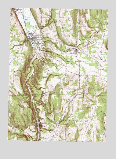
Montour Falls, NY USGS Topographic Map
Click on map above to begin viewing in our Map Viewer.

This topographic map contains these locations and features:
Feature Name Type Latitude Longitude GNIS ID View Map
Aunt Sarahs FallsFallsN42.3509°W76.8586°942703View Map
B C Cate Elementary SchoolSchoolN42.3386°W76.8414°2416959View Map
Bad Indian SwampSwampN42.3654°W76.8541°973978View Map
Beardsley HollowValleyN42.3202°W76.7819°943332View Map
Bethel Fellowship ChurchChurchN42.3325°W76.8386°2514274View Map
Bible Speaks Community ChurchChurchN42.2658°W76.8353°2514268View Map
BrookhavenPopulated PlaceN42.2764°W76.8383°2514288View Map
CatharinePopulated PlaceN42.3129°W76.7847°946037View Map
Catharine CreekStreamN42.3515°W76.8511°946038View Map
Catharine Creek Wildlife Management AreaParkN42.3687°W76.8511°2025326View Map
Catharine Town HallBuildingN42.3397°W76.7784°2617589View Map
Catharine United Methodist ChurchChurchN42.3126°W76.7862°2615689View Map
Catharine ValleyValleyN42.3362°W76.8380°969974View Map
Catlin Mill CreekStreamN42.3456°W76.8372°973995View Map
Coe CemeteryCemeteryN42.3257°W76.8080°946992View Map
Cook CemeteryCemeteryN42.3365°W76.8424°947340View Map
Cranberry CreekStreamN42.3395°W76.7805°974005View Map
Crandall MountainSummitN42.2526°W76.8575°947686View Map
DeckertownPopulated PlaceN42.3437°W76.8319°948163View Map
Diversion ChannelChannelN42.3467°W76.8383°973639View Map
Dunn HillSummitN42.2545°W76.8686°948810View Map
Dutton S Peterson Memorial LibraryBuildingN42.3360°W76.7894°2617260View Map
Ervay's MarinaLocaleN42.3706°W76.8593°2617478View Map
First Baptist ChurchChurchN42.3447°W76.8469°2514481View Map
Havana GlenValleyN42.3353°W76.8293°952384View Map
Havana Glen Mobile Home ParkPopulated PlaceN42.3367°W76.8342°2514470View Map
Highland CemeteryCemeteryN42.3208°W76.8019°952778View Map
Howard A Hanlon Elementary SchoolSchoolN42.3355°W76.7922°2668865View Map
Johns CreekStreamN42.3554°W76.8450°974032View Map
Johnson HollowValleyN42.2509°W76.8386°954126View Map
Kingdom Hall of Jehovahs WitnessesChurchN42.3586°W76.8687°2616574View Map
L'Hommedieu CreekStreamN42.3565°W76.8533°954844View Map
Laurel Hill CemeteryCemeteryN42.3524°W76.7550°955089View Map
Lhommedieu Street BridgeBridgeN42.3552°W76.8368°2614938View Map
Marina ParkParkN42.3559°W76.8536°973696View Map
MidwayPopulated PlaceN42.2515°W76.8375°957164View Map
Mill Street BridgeBridgeN42.3444°W76.8517°2614953View Map
MillportPopulated PlaceN42.2654°W76.8347°957345View Map
Millport CemeteryCemeteryN42.2670°W76.8319°2514382View Map
Millport Post OfficePost OfficeN42.2518°W76.8366°2598536View Map
Millport Volunteer Fire DepartmentBuildingN42.2653°W76.8358°2735110View Map
Mitchell HollowValleyN42.3317°W76.8172°957444View Map
Montour FallsPopulated PlaceN42.3473°W76.8452°974235View Map
Montour Falls Fire DepartmentBuildingN42.3456°W76.8477°2700958View Map
Montour Falls MarinaLocaleN42.3538°W76.8529°2617487View Map
Montour Falls Memorial LibraryBuildingN42.3458°W76.8495°2617351View Map
Montour Falls Memorial LibraryBuildingN42.3458°W76.8494°2514482View Map
Montour Falls Post OfficePost OfficeN42.3459°W76.8482°2618025View Map
Montour Falls United Methodist ChurchChurchN42.3447°W76.8469°2416960View Map
Montour Falls Village Sewage Treatment PlantLocaleN42.3518°W76.8511°2617739View Map
Montour Falls Yacht ClubLocaleN42.3611°W76.8550°2617488View Map
Mount Calvary Lutheran ChurchChurchN42.3457°W76.8497°2616735View Map
Mount PleasantSummitN42.3704°W76.7777°960743View Map
New Hope Baptist ChurchChurchN42.2672°W76.8375°2514269View Map
North Settlement CemeteryCemeteryN42.3266°W76.7516°958914View Map
OdessaPopulated PlaceN42.3367°W76.7886°959224View Map
Odessa - Montour Middle - High SchoolSchoolN42.3350°W76.7927°2669070View Map
Odessa Baptist ChurchChurchN42.3353°W76.7900°2514478View Map
Odessa Fire DepartmentBuildingN42.3359°W76.7862°2700959View Map
Odessa Post OfficePost OfficeN42.3367°W76.7862°2618048View Map
Odessa United Methodist ChurchChurchN42.3344°W76.7897°2514479View Map
Parsons CemeteryCemeteryN42.2581°W76.8142°2514383View Map
Saint Benedict's ChurchChurchN42.3330°W76.7924°2616884View Map
Saint John CemeteryCemeteryN42.2717°W76.8093°2514384View Map
Saint Johns SeminarySchoolN42.3415°W76.8383°963690View Map
School Number 1SchoolN42.2748°W76.7663°974867View Map
School Number 4SchoolN42.2520°W76.8383°975313View Map
School Number 9SchoolN42.2626°W76.8669°975619View Map
Schuyler County Volunteer AmbulanceBuildingN42.3696°W76.8657°2719235View Map
Schuyler HospitalHospitalN42.3525°W76.8599°2614551View Map
Shequaga CreekStreamN42.3506°W76.8491°965060View Map
Shequaga FallsFallsN42.3448°W76.8511°965061View Map
Sleeper CreekStreamN42.2865°W76.8436°965398View Map
Terry HillSummitN42.2809°W76.7663°973638View Map
The Falls Home for AdultsBuildingN42.3463°W76.8498°2614808View Map
Town of MontourCivilN42.3373°W76.8242°979233View Map
Village of MillportCivilN42.2681°W76.8362°2390986View Map
Village of Montour FallsCivilN42.3499°W76.8483°2390994View Map
Village of OdessaCivilN42.3350°W76.7881°2391033View Map
Watkins Glen Elementary SchoolSchoolN42.3725°W76.8653°2416957View Map
Watkins Glen High SchoolSchoolN42.3742°W76.8647°2416958View Map
Wesleyan ChurchChurchN42.3344°W76.7903°2514480View Map
WGMF-AM (Watkins Glen)TowerN42.3531°W76.8700°978482View Map

Note: Coordinates in the location and feature list above are referenced to NAD83 datum.


Copyright (C) 2008-2024 Ryan Niemi / Sunset Dynamics ... All Rights Reserved