TopoQuest Logo
Do you find TopoQuest useful?
Help keep TopoQuest running and adding new maps/features by donating!
Bitcoin:  19c7KJd3qBynnjoSw5npx9KScwjBe4ifkT
Litecoin:  LXs6TkuXGGXo1vDsWCkWVdjQX94eUKd6ui
Home View Maps Find Maps Find Places Resources & Links


Kinikinik, Colorado Topographic Map

USGS Map Title: Kinikinik, CO
USGS Map MRC: 40105F6
DRG (GeoTIFF) Download: o40105f6.tif


Neighboring USGS Topographic Map Quads:


  Deadman, CO  
40105G7
 

  South Bald Mountain, CO  
40105G6
 

  Red Feather Lakes, CO  
40105G5
 

  Boston Peak, CO  
40105F7
 

  Kinikinik, CO  
40105F6
 

  Rustic, CO  
40105F5
 

  Chambers Lake, CO  
40105E7
 

  Comanche Peak, CO  
40105E6
 

  Pingree Park, CO  
40105E5


Map MRC Location:

N41°
W106°
N41°
W105°
H8 H7 H6 H5 H4 H3 H2 H1
G8 G7 G6 G5 G4 G3 G2 G1
F8 F7 F6 F5 F4 F3 F2 F1
E8 E7 E6 E5 E4 E3 E2 E1
D8 D7 D6 D5 D4 D3 D2 D1
C8 C7 C6 C5 C4 C3 C2 C1
B8 B7 B6 B5 B4 B3 B2 B1
A8 A7 A6 A5 A4 A3 A2 A1
N40°
W106°
N40°
W105°

Kinikinik, CO USGS 1:24K Topographic Map Preview:
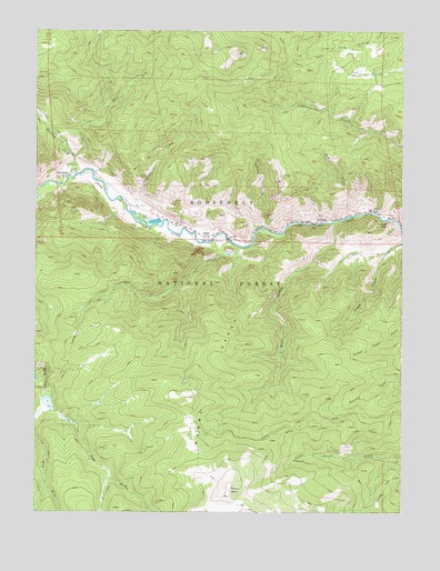
Kinikinik, CO USGS Topographic Map
Click on map above to begin viewing in our Map Viewer.

This topographic map contains these locations and features:
Feature Name Type Latitude Longitude GNIS ID View Map
Arrowhead LodgeLocaleN40.7036°W105.6364°177099View Map
Big Bend CampgroundLocaleN40.7075°W105.7247°197902View Map
Black HollowValleyN40.7006°W105.6482°177110View Map
Browns Lake TrailheadLocaleN40.6491°W105.6986°197900View Map
Campbell CemeteryCemeteryN40.7022°W105.7197°2036982View Map
Chaney-Sims Beryl MineMineN40.6930°W105.6400°1683373View Map
Charles E Williams GraveCemeteryN40.7150°W105.7400°2036924View Map
Colorado State Fish HatcheryLocaleN40.7003°W105.7100°197901View Map
Crown PointSummitN40.6291°W105.6847°177109View Map
Dadd Gulch TrailTrailN40.6444°W105.6672°202430View Map
Dry CreekStreamN40.7030°W105.6375°177106View Map
East Fork Roaring CreekStreamN40.7172°W105.7039°170252View Map
East Fork Sheep CreekStreamN40.6544°W105.7481°177103View Map
HomeLocaleN40.6961°W105.6922°177101View Map
IdylwildePopulated PlaceN40.7008°W105.6547°177100View Map
KinikinikPopulated PlaceN40.7125°W105.7381°177104View Map
Peterson CreekStreamN40.7008°W105.7142°177107View Map
Profile RockCliffN40.7000°W105.6306°177098View Map
Roaring CreekStreamN40.7125°W105.7369°170262View Map
Roaring Creek TrailheadLocaleN40.7133°W105.7381°197903View Map
Sheep CreekStreamN40.6966°W105.6542°177115View Map
Sheep GulchValleyN40.6926°W105.6308°177108View Map
Swamp Creek Cutoff TrailTrailN40.7416°W105.6506°201903View Map
Washout GulchValleyN40.6990°W105.6729°177105View Map
West Fork Sheep CreekStreamN40.6544°W105.7481°177072View Map

Note: Coordinates in the location and feature list above are referenced to NAD83 datum.


Copyright (C) 2008-2024 Ryan Niemi / Sunset Dynamics ... All Rights Reserved