TopoQuest Logo
Do you find TopoQuest useful?
Help keep TopoQuest running and adding new maps/features by donating!
Bitcoin:  19c7KJd3qBynnjoSw5npx9KScwjBe4ifkT
Litecoin:  LXs6TkuXGGXo1vDsWCkWVdjQX94eUKd6ui
Home View Maps Find Maps Find Places Resources & Links


Kassler, Colorado Topographic Map

USGS Map Title: Kassler, CO
USGS Map MRC: 39105D1
DRG (GeoTIFF) Download: o39105d1.tif


Neighboring USGS Topographic Map Quads:


  Indian Hills, CO  
39105E2
 

  Littleton, CO  
39105E1
 

  Highlands Ranch, CO  
39104E8
 

  Platte Canyon, CO  
39105D2
 

  Kassler, CO  
39105D1
 

  Sedalia, CO  
39104D8
 

  Deckers, CO  
39105C2
 

  Devils Head, CO  
39105C1
 

  Dawson Butte, CO  
39104C8


Map MRC Location:

N40°
W106°
N40°
W105°
H8 H7 H6 H5 H4 H3 H2 H1
G8 G7 G6 G5 G4 G3 G2 G1
F8 F7 F6 F5 F4 F3 F2 F1
E8 E7 E6 E5 E4 E3 E2 E1
D8 D7 D6 D5 D4 D3 D2 D1
C8 C7 C6 C5 C4 C3 C2 C1
B8 B7 B6 B5 B4 B3 B2 B1
A8 A7 A6 A5 A4 A3 A2 A1
N39°
W106°
N39°
W105°

Kassler, CO USGS 1:24K Topographic Map Preview:
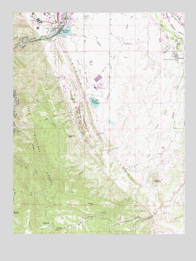
Kassler, CO USGS Topographic Map
Click on map above to begin viewing in our Map Viewer.

This topographic map contains these locations and features:
Feature Name Type Latitude Longitude GNIS ID View Map
Arrowhead Golf CourseLocaleN39.4514°W105.0811°197630View Map
Aurora Filtration PlantLocaleN39.4822°W105.0436°183352View Map
Aurora Rampart Tunnel Number 2TunnelN39.4425°W105.0880°183375View Map
Aurora-Rampart DamDamN39.4500°W105.0655°198658View Map
Aurora-Rampart ReservoirReservoirN39.4492°W105.0656°198659View Map
Bennett MountainSummitN39.3864°W105.1242°183377View Map
Brush CreekStreamN39.4911°W105.0900°183342View Map
Cann HillSummitN39.4236°W105.0153°183354View Map
Carpenter PeakSummitN39.4300°W105.0844°183360View Map
Cottonwood GulchValleyN39.4814°W105.1209°183343View Map
Duke PitMineN39.4872°W105.0822°1703758View Map
Helmer Lime QuarryMineN39.4364°W105.0703°1703760View Map
Highlands GulchValleyN39.4967°W105.0048°196502View Map
Hillside MineMineN39.4633°W105.0819°1703761View Map
Hogback Number Four MineMineN39.4814°W105.0819°1703764View Map
Hogback Number Three MineMineN39.4814°W105.0819°1703763View Map
Hogback Number Two MineMineN39.4814°W105.0819°1703762View Map
Indian CreekStreamN39.4714°W105.0022°183378View Map
Indian Creek CampgroundLocaleN39.3811°W105.0992°183371View Map
Indian Creek Guard StationLocaleN39.3783°W105.0933°183370View Map
Jarre CanyonValleyN39.3855°W105.0223°183374View Map
KasslerPopulated PlaceN39.4905°W105.0947°204729View Map
Kassler QuarryMineN39.4814°W105.1053°1703765View Map
Lambert DamDamN39.4317°W105.0072°200920View Map
Lambert ReservoirReservoirN39.4317°W105.0072°200921View Map
Lehigh GulchValleyN39.4496°W105.0054°183355View Map
Lehow CemeteryCemeteryN39.4970°W105.0943°2734656View Map
Little QuarryMineN39.4992°W105.1028°1703772View Map
Little Willow CreekStreamN39.4869°W105.0825°183361View Map
Lockheed Martin Space Systems Company Plant Fire DepartmentBuildingN39.4951°W105.0995°2667024View Map
LouviersPopulated PlaceN39.4778°W105.0072°183350View Map
Louviers Census Designated PlaceCensusN39.4799°W105.0033°2408145View Map
Louviers Post OfficePost OfficeN39.4765°W105.0068°2759204View Map
Martin HeliportAirportN39.4994°W105.1067°204616View Map
Meadow DitchCanalN39.4344°W105.0057°2723532View Map
Mill GulchValleyN39.4549°W105.1240°183362View Map
Nelson DamDamN39.4100°W105.0422°200494View Map
Nelson ReservoirReservoirN39.4101°W105.0422°200495View Map
Penley Number One Lease MineMineN39.3967°W105.0261°1703759View Map
Pine NookPopulated PlaceN39.3842°W105.0714°183366View Map
Platte CanyonValleyN39.4849°W105.1043°183347View Map
Platte Canyon DamDamN39.4897°W105.0900°200922View Map
Platte Canyon ReservoirReservoirN39.4895°W105.0865°183379View Map
Pre-mix Sand and Gravel Incorporated QuarryMineN39.4814°W105.0936°1703766View Map
Rainbow CreekStreamN39.4197°W105.0119°183368View Map
RoxboroughPopulated PlaceN39.4693°W105.0856°2677776View Map
Roxborough Intermediate SchoolSchoolN39.4684°W105.0711°2439204View Map
Roxborough ParkFlatN39.4400°W105.0747°183359View Map
Roxborough ParkPopulated PlaceN39.4739°W105.0853°1852848View Map
Roxborough Park Census Designated PlaceCensusN39.4492°W105.0746°2409221View Map
Roxborough Park MineMineN39.4544°W105.0703°1703767View Map
Roxborough Primary SchoolSchoolN39.4773°W105.0760°2439188View Map
Saddle Rock Ranch MineMineN39.3822°W105.0239°1703768View Map
Slocum MineMineN39.4814°W105.0819°1703769View Map
South Metro Fire Rescue Station 41 (historical)BuildingN39.4777°W105.0069°2368693View Map
Stevens GulchValleyN39.4346°W105.1230°183372View Map
Sundance RanchLocaleN39.4214°W105.0519°183356View Map
Thomas HillSummitN39.3922°W105.0664°183367View Map
Titan PitMineN39.4905°W105.0819°1703770View Map
Wakeman DamDamN39.4383°W105.0555°198748View Map
Wakeman ReservoirReservoirN39.4382°W105.0539°198749View Map
WatertonPopulated PlaceN39.4936°W105.0886°183349View Map
Waterton SubstationLocaleN39.4972°W105.0714°183353View Map
West Bear CreekStreamN39.4208°W105.1250°183344View Map
West Douglas County Fire Protection District Station 132BuildingN39.3868°W105.0221°2368695View Map
West Douglas County Fire Protection District Station 133BuildingN39.4166°W105.0169°2368694View Map
West Metro Fire Rescue Station 15BuildingN39.4529°W105.0715°2368765View Map
Wildcat MineMineN39.4003°W105.0239°1703771View Map
Wildcat MountainSummitN39.4047°W105.0217°183364View Map
Willow CreekStreamN39.4980°W105.0855°183369View Map
Willow Creek RanchLocaleN39.4505°W105.0578°183357View Map
Woodbine RanchLocaleN39.3803°W105.0483°183365View Map

Note: Coordinates in the location and feature list above are referenced to NAD83 datum.


Copyright (C) 2008-2024 Ryan Niemi / Sunset Dynamics ... All Rights Reserved