TopoQuest Logo
Do you find TopoQuest useful?
Help keep TopoQuest running and adding new maps/features by donating!
Bitcoin:  19c7KJd3qBynnjoSw5npx9KScwjBe4ifkT
Litecoin:  LXs6TkuXGGXo1vDsWCkWVdjQX94eUKd6ui
Home View Maps Find Maps Find Places Resources & Links


Greenwood, Arkansas Topographic Map

USGS Map Title: Greenwood, AR
USGS Map MRC: 35094B3
DRG (GeoTIFF) Download: o35094b3.tif


Neighboring USGS Topographic Map Quads:


  South Fort Smith, AR  
35094C4
 

  Barling, AR  
35094C3
 

  Lavaca, AR  
35094C2
 

  Hackett, AR  
35094B4
 

  Greenwood, AR  
35094B3
 

  Burnville, AR  
35094B2
 

  Hartford, AR  
35094A4
 

  Huntington, AR  
35094A3
 

  Abbott, AR  
35094A2


Map MRC Location:

N36°
W95°
N36°
W94°
H8 H7 H6 H5 H4 H3 H2 H1
G8 G7 G6 G5 G4 G3 G2 G1
F8 F7 F6 F5 F4 F3 F2 F1
E8 E7 E6 E5 E4 E3 E2 E1
D8 D7 D6 D5 D4 D3 D2 D1
C8 C7 C6 C5 C4 C3 C2 C1
B8 B7 B6 B5 B4 B3 B2 B1
A8 A7 A6 A5 A4 A3 A2 A1
N35°
W95°
N35°
W94°

Greenwood, AR USGS 1:24K Topographic Map Preview:
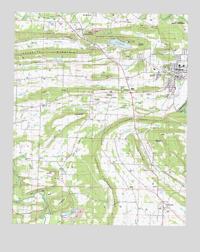
Greenwood, AR USGS Topographic Map
Click on map above to begin viewing in our Map Viewer.

This topographic map contains these locations and features:
Feature Name Type Latitude Longitude GNIS ID View Map
Adamson CreekStreamN35.2081°W94.2533°45789View Map
Backbone MountainSummitN35.2251°W94.3577°45997View Map
Bell ParkParkN35.2270°W94.2677°56721View Map
Big RockPopulated PlaceN35.1745°W94.2783°57375View Map
Billcol MountainSummitN35.1376°W94.3380°46620View Map
Bonanza Gas FieldOilfieldN35.2448°W94.3627°67197View Map
Buckner ParkParkN35.1340°W94.2660°56708View Map
Clarkeen CemeteryCemeteryN35.1637°W94.3566°47808View Map
Devils Backbone RidgeRidgeN35.1587°W94.3150°71373View Map
Diffy MountainSummitN35.1551°W94.3458°48512View Map
Donahue MountainSummitN35.2337°W94.2905°57672View Map
Doubleday CemeteryCemeteryN35.1854°W94.3697°48580View Map
Douglass CemeteryCemeteryN35.2443°W94.3433°48590View Map
ExcelsiorPopulated PlaceN35.2001°W94.3144°76891View Map
Excelsior Baptist ChurchChurchN35.1968°W94.3144°67209View Map
Excelsior/ Mount Zion / Palestine Rural Fire DepartmentBuildingN35.1695°W94.3318°2116416View Map
First Baptist Church of GreenwoodChurchN35.2131°W94.2574°67213View Map
Full Gospel LighthouseChurchN35.2020°W94.3069°56717View Map
Gentry CemeteryCemeteryN35.2429°W94.2763°56723View Map
Gilliam CemeteryCemeteryN35.1620°W94.3038°56712View Map
GreenwoodPopulated PlaceN35.2156°W94.2558°57848View Map
Greenwood Elementary SchoolSchoolN35.2201°W94.2560°67221View Map
Greenwood High SchoolSchoolN35.2196°W94.2532°67222View Map
Greenwood Police DepartmentBuildingN35.2131°W94.2523°2118920View Map
Greenwood Post OfficePost OfficeN35.2141°W94.2529°84389View Map
Greenwood Reservoir DamDamN35.1939°W94.2516°80696View Map
Greenwood Volunteer Fire DepartmentBuildingN35.2131°W94.2523°2116508View Map
Griffith MountainSummitN35.1893°W94.3274°49678View Map
Hester CreekStreamN35.2159°W94.2669°56720View Map
Jenny Lind Baptist ChurchChurchN35.2398°W94.3260°67233View Map
Jenny Lind SchoolSchoolN35.2395°W94.3308°50625View Map
KBBQ-FM (Fort Smith)TowerN35.2256°W94.3416°85182View Map
Kingdom HallChurchN35.2026°W94.3058°56716View Map
KVOG-AM (Greenwood)TowerN35.2034°W94.2783°85081View Map
KZKZ-FM (Greenwood)TowerN35.2287°W94.2627°85183View Map
Long RidgeRidgeN35.2401°W94.3013°51442View Map
Lovelace CemeteryCemeteryN35.1362°W94.2688°56709View Map
Mackenay CreekStreamN35.1315°W94.3488°51591View Map
Mount Zineche CemeteryCemeteryN35.2115°W94.3524°52437View Map
Mount Zion Baptist ChurchChurchN35.2115°W94.3533°67245View Map
New Hope Baptist ChurchChurchN35.2237°W94.2924°78849View Map
North Main Elementary SchoolSchoolN35.2201°W94.2562°2039145View Map
Old Jenny LindPopulated PlaceN35.2401°W94.3269°58302View Map
Old Town ChurchChurchN35.2395°W94.3285°53029View Map
Palestine Baptist ChurchChurchN35.1673°W94.3008°77944View Map
Palestine SchoolSchoolN35.1682°W94.3008°53138View Map
Pleasant Hill CemeteryCemeteryN35.1854°W94.3702°56714View Map
Pleasant Hill ChurchChurchN35.1948°W94.3549°56715View Map
Ramsey CemeteryCemeteryN35.1304°W94.3569°56711View Map
Sand RidgeRidgeN35.2048°W94.3144°54542View Map
Sebastian CountyCivilN35.1997°W94.2741°69181View Map
Sebastian County Emergency Medical Services GreenwoodBuildingN35.2095°W94.2599°2119122View Map
Sebastian County Sheriff's Office Greenwood DistrictBuildingN35.2118°W94.2553°2118918View Map
Shadow LakeReservoirN35.2326°W94.2997°81115View Map
Shadow Lake DamDamN35.2334°W94.3069°81114View Map
Short MountainSummitN35.1934°W94.2874°54829View Map
Skinner HillSummitN35.2048°W94.2897°58632View Map
Stroud CemeteryCemeteryN35.1868°W94.3127°56713View Map
Towne West Shopping CenterLocaleN35.2176°W94.2741°67266View Map
Township of Bass LittleCivilN35.2047°W94.3217°69100View Map
Township of PrairieCivilN35.1367°W94.2850°69116View Map
Township of RogersCivilN35.2492°W94.3130°69117View Map
Valley View CemeteryCemeteryN35.1515°W94.3402°56710View Map
Valley View ChurchChurchN35.2026°W94.3183°56718View Map
Vineyard BranchStreamN35.1840°W94.2785°55921View Map
Westwood Elementary SchoolSchoolN35.2176°W94.2927°2121471View Map
White Rock MountainSummitN35.1740°W94.2688°56307View Map
Williamson LakeReservoirN35.2378°W94.2857°80693View Map
Williamson Lake DamDamN35.2368°W94.2835°80692View Map
WitchervillePopulated PlaceN35.1376°W94.2644°78793View Map
Young RidgeRidgeN35.1712°W94.2866°56613View Map

Note: Coordinates in the location and feature list above are referenced to NAD83 datum.


Copyright (C) 2008-2024 Ryan Niemi / Sunset Dynamics ... All Rights Reserved