TopoQuest Logo
Do you find TopoQuest useful?
Help keep TopoQuest running and adding new maps/features by donating!
Bitcoin:  19c7KJd3qBynnjoSw5npx9KScwjBe4ifkT
Litecoin:  LXs6TkuXGGXo1vDsWCkWVdjQX94eUKd6ui
Home View Maps Find Maps Find Places Resources & Links


Gordonsburg, Tennessee Topographic Map

USGS Map Title: Gordonsburg, TN
USGS Map MRC: 35087E4
DRG (GeoTIFF) Download: o35087e4.tif


Neighboring USGS Topographic Map Quads:


  Beaverdam Springs, TN  
35087F5
 

  Sunrise, TN  
35087F4
 

  Greenfield Bend, TN  
35087F3
 

  Hohenwald, TN  
35087E5
 

  Gordonsburg, TN  
35087E4
 

  Mount Joy, TN  
35087E3
 

  Riverside, TN  
35087D5
 

  Henryville, TN  
35087D4
 

  Summertown, TN  
35087D3


Map MRC Location:

N36°
W88°
N36°
W87°
H8 H7 H6 H5 H4 H3 H2 H1
G8 G7 G6 G5 G4 G3 G2 G1
F8 F7 F6 F5 F4 F3 F2 F1
E8 E7 E6 E5 E4 E3 E2 E1
D8 D7 D6 D5 D4 D3 D2 D1
C8 C7 C6 C5 C4 C3 C2 C1
B8 B7 B6 B5 B4 B3 B2 B1
A8 A7 A6 A5 A4 A3 A2 A1
N35°
W88°
N35°
W87°

Gordonsburg, TN USGS 1:24K Topographic Map Preview:
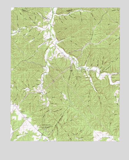
Gordonsburg, TN USGS Topographic Map
Click on map above to begin viewing in our Map Viewer.

This topographic map contains these locations and features:
Feature Name Type Latitude Longitude GNIS ID View Map
Anderson BranchStreamN35.5690°W87.4097°1275684View Map
Auntney HollowValleyN35.5147°W87.4424°1275984View Map
Beech BranchStreamN35.6181°W87.4447°1276800View Map
Bennett RidgeRidgeN35.5395°W87.3795°1269268View Map
Berry HollowValleyN35.6232°W87.4189°1269333View Map
Big Siding (historical)LocaleN35.5631°W87.3839°1309366View Map
Black BranchStreamN35.5704°W87.4570°1277544View Map
Blackwell CemeteryCemeteryN35.5656°W87.4011°1309368View Map
Bradford HollowValleyN35.5179°W87.4459°1278167View Map
Briar BranchStreamN35.5706°W87.4575°1307318View Map
Brush CreekStreamN35.5462°W87.4639°1305472View Map
Brush Creek SchoolSchoolN35.5456°W87.4653°1278687View Map
Burl HollowValleyN35.5983°W87.3754°1279059View Map
Cade BranchStreamN35.5984°W87.3753°1309375View Map
Carrol Bank ProspectMineN35.6098°W87.4772°1309376View Map
Collier BranchStreamN35.5087°W87.4358°1309387View Map
Collier HollowValleyN35.5083°W87.4360°1280981View Map
Commissioner District 2CivilN35.5865°W87.4246°2463944View Map
Cubbington HollowValleyN35.5696°W87.4085°1309390View Map
Cudge HollowValleyN35.6043°W87.4639°1281808View Map
Dark HollowValleyN35.5049°W87.4260°1282042View Map
Dedin HollowValleyN35.5495°W87.4791°1282280View Map
Douglas CemeteryCemeteryN35.6070°W87.4597°1309392View Map
Dry BranchStreamN35.6203°W87.4520°1269538View Map
Dyestone HollowValleyN35.5291°W87.4549°1283270View Map
Eel BranchStreamN35.5640°W87.4567°1283568View Map
Eel Branch ProspectMineN35.5445°W87.4389°1309398View Map
English Camp HollowValleyN35.5174°W87.4459°1283794View Map
English HollowValleyN35.6145°W87.4571°1283799View Map
Fall BranchStreamN35.5479°W87.4820°1284055View Map
Fall HollowValleyN35.5810°W87.4335°1284081View Map
Faucette HollowValleyN35.5767°W87.4290°1284167View Map
Flat WoodsAreaN35.5209°W87.4875°1309401View Map
Garrett HollowValleyN35.6074°W87.4698°1285200View Map
Georgia BranchStreamN35.5151°W87.4431°1285311View Map
GordonsburgPopulated PlaceN35.5698°W87.4239°1315135View Map
Gordonsburg CemeteryCemeteryN35.5698°W87.4014°1309407View Map
Gordonsburg Church of ChristChurchN35.5709°W87.4239°1309408View Map
Greenbriar HollowValleyN35.5707°W87.3942°1286138View Map
Grinders Creek CemeteryCemeteryN35.5101°W87.4964°1309409View Map
Grinders Inn (historical)LocaleN35.5092°W87.4597°1309411View Map
Harder CemeteryCemeteryN35.5951°W87.4553°1286806View Map
Hartley BranchStreamN35.5351°W87.4547°1287051View Map
Hartley BranchStreamN35.5412°W87.4592°1649947View Map
Hartley Branch ProspectMineN35.5340°W87.4414°1309413View Map
Hensley CemeteryCemeteryN35.5598°W87.4142°1287457View Map
Hensley HollowValleyN35.5404°W87.4579°1287466View Map
Hick Hill BranchStreamN35.5490°W87.4042°1287533View Map
Hog HollowValleyN35.6118°W87.4735°1287981View Map
Indian CreekStreamN35.6106°W87.4556°1307349View Map
Indian Creek SchoolSchoolN35.6031°W87.4925°1288979View Map
Jack HollowValleyN35.5568°W87.4648°1289154View Map
Jagger HollowValleyN35.5689°W87.4004°1289251View Map
Jerden HollowValleyN35.5014°W87.4997°1289391View Map
Joby HollowValleyN35.5478°W87.4929°1289448View Map
Johnson CemeteryCemeteryN35.5826°W87.4411°1289549View Map
Johnson HollowValleyN35.5931°W87.4468°1289610View Map
Jones HollowValleyN35.5963°W87.4533°1289798View Map
Kittrell BranchStreamN35.5690°W87.4011°1290328View Map
Kittrell HillSummitN35.5667°W87.3931°1290333View Map
Langford BranchStreamN35.5620°W87.3883°1290616View Map
Lewis CountyCivilN35.5273°W87.4931°1639765View Map
Lewis ParkLocaleN35.5220°W87.4836°1291088View Map
Limestone HollowValleyN35.5025°W87.4323°1291300View Map
Lindsey RidgeRidgeN35.5962°W87.4847°1291329View Map
Line HollowValleyN35.5348°W87.4546°1309434View Map
Little Grinders CreekStreamN35.5679°W87.4161°1291517View Map
Little Swan ChurchChurchN35.5529°W87.4672°1306696View Map
Little Swan CreekStreamN35.5912°W87.4483°1291684View Map
Low Gap BranchStreamN35.5931°W87.4472°1649951View Map
Low Gap Branch Prospect Number OneMineN35.6006°W87.4389°1309437View Map
Low Gap Branch Prospect Number TwoMineN35.5856°W87.4167°1309438View Map
Lyon ProspectMineN35.5126°W87.4597°1309441View Map
Mail HollowValleyN35.5451°W87.4100°1292512View Map
Meriwether Lewis National MonumentParkN35.5117°W87.4611°1293624View Map
Mitchell HollowValleyN35.6004°W87.4496°1294106View Map
Mount Sinai CemeteryCemeteryN35.5723°W87.4503°1294790View Map
Mount Sinai Church (historical)ChurchN35.5812°W87.4508°1309447View Map
Natchez Trace ProspectMineN35.5317°W87.4322°1309454View Map
Newburg (historical)Populated PlaceN35.5167°W87.4139°1309455View Map
Old Harder CemeteryCemeteryN35.6212°W87.4531°1296320View Map
Old SpringSpringN35.5137°W87.4549°1296372View Map
Palestine (historical)Populated PlaceN35.5976°W87.4550°1309461View Map
Palestine CemeteryCemeteryN35.5990°W87.4553°1296679View Map
Panther HollowValleyN35.5466°W87.4904°1296749View Map
Peavyhouse HollowValleyN35.5277°W87.4522°1297090View Map
Perismmon BranchStreamN35.5959°W87.4531°1309462View Map
Piney BranchStreamN35.5529°W87.4650°1307364View Map
Piney CemeteryCemeteryN35.5490°W87.4808°1297616View Map
Pioneer CemeteryCemeteryN35.5109°W87.4606°1647193View Map
Plazy HollowValleyN35.5500°W87.4808°1297782View Map
Quillen HollowValleyN35.6064°W87.4753°1298762View Map
Rabbitt KnobSummitN35.5670°W87.4283°1298779View Map
Rhodes CemeteryCemeteryN35.5912°W87.4589°1309467View Map
Rocky BranchStreamN35.6040°W87.4945°1307370View Map
SalemPopulated PlaceN35.6151°W87.4583°1300535View Map
Salem CemeteryCemeteryN35.6145°W87.4572°1309474View Map
Sammies BranchStreamN35.5317°W87.4561°1300632View Map
Silky HollowValleyN35.5436°W87.4601°1270267View Map
Simmons HollowValleyN35.6210°W87.4089°1270317View Map
Sisco CemeteryCemeteryN35.6190°W87.4308°1270397View Map
Smith CemeteryCemeteryN35.6078°W87.4522°1309484View Map
Smoky HollowValleyN35.5671°W87.4231°1270724View Map
Spring HollowValleyN35.6223°W87.4212°1271116View Map
Springer CemeteryCemeteryN35.5278°W87.4889°1309486View Map
Springer Ridge (historical)Populated PlaceN35.5265°W87.4889°1309487View Map
Springer Ridge ChurchChurchN35.5273°W87.4889°1303774View Map
Stockard ProspectMineN35.5592°W87.4028°1309489View Map
Stoney- Lonesome CemeteryCemeteryN35.5606°W87.4200°1271511View Map
Suck BranchStreamN35.6176°W87.4389°1271630View Map
Sugarcamp HollowValleyN35.6192°W87.4339°1271713View Map
Swan Valley OverlookLocaleN35.5862°W87.4206°1647746View Map
Sweet HollowValleyN35.6128°W87.4753°1271971View Map
Tanyard HollowValleyN35.5443°W87.3994°1272112View Map
Tate BranchStreamN35.5084°W87.4358°1309492View Map
Tate HollowValleyN35.5083°W87.4362°1272158View Map
Touchmenot HollowValleyN35.6050°W87.4897°1272789View Map
Wade HollowValleyN35.5963°W87.3758°1273520View Map
Walker CemeteryCemeteryN35.5598°W87.3842°1273590View Map
Wilson Branch - Cade Branch ProspectMineN35.6051°W87.4000°1309501View Map
Wiss HollowValleyN35.5960°W87.4339°1274917View Map
Wright CemeteryCemeteryN35.5209°W87.4803°1309505View Map
Yankee HollowValleyN35.5702°W87.4145°1275229View Map

Note: Coordinates in the location and feature list above are referenced to NAD83 datum.


Copyright (C) 2008-2024 Ryan Niemi / Sunset Dynamics ... All Rights Reserved