TopoQuest Logo
Do you find TopoQuest useful?
Help keep TopoQuest running and adding new maps/features by donating!
Bitcoin:  19c7KJd3qBynnjoSw5npx9KScwjBe4ifkT
Litecoin:  LXs6TkuXGGXo1vDsWCkWVdjQX94eUKd6ui
Home View Maps Find Maps Find Places Resources & Links


Georgetown, Georgia Topographic Map

USGS Map Title: Georgetown, GA
USGS Map MRC: 31085H1
DRG (GeoTIFF) Download: o31085h1.tif


Neighboring USGS Topographic Map Quads:


  Howe, AL  
32085A2
 

  Twin Springs, AL  
32085A1
 

  Lumpkin SW, GA  
32084A8
 

  Eufaula North, AL  
31085H2
 

  Georgetown, GA  
31085H1
 

  Sanford, GA  
31084H8
 

  Eufaula South, AL  
31085G2
 

  Hatcher, GA  
31085G1
 

  Morris, GA  
31084G8


Map MRC Location:

N32°
W86°
N32°
W85°
H8 H7 H6 H5 H4 H3 H2 H1
G8 G7 G6 G5 G4 G3 G2 G1
F8 F7 F6 F5 F4 F3 F2 F1
E8 E7 E6 E5 E4 E3 E2 E1
D8 D7 D6 D5 D4 D3 D2 D1
C8 C7 C6 C5 C4 C3 C2 C1
B8 B7 B6 B5 B4 B3 B2 B1
A8 A7 A6 A5 A4 A3 A2 A1
N31°
W86°
N31°
W85°

Georgetown, GA USGS 1:24K Topographic Map Preview:
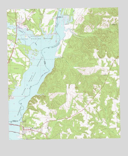
Georgetown, GA USGS Topographic Map
Click on map above to begin viewing in our Map Viewer.

This topographic map contains these locations and features:
Feature Name Type Latitude Longitude GNIS ID View Map
Avreys Store (historical)LocaleN31.9760°W85.0497°350536View Map
Bumbleton CourthouseBuildingN31.9354°W85.0138°312031View Map
Bustahatchee CreekStreamN31.9799°W85.0633°312091View Map
City of Georgetown (historical)CivilN31.8856°W85.1049°2403691View Map
Cool BranchStreamN31.9938°W85.0860°116542View Map
Cowikee CreekStreamN31.9607°W85.0863°155041View Map
Cowikee Recreation AreaParkN31.9852°W85.1088°116762View Map
Eufaula National Wildlife RefugeParkN31.9957°W85.0830°118052View Map
GeorgetownPopulated PlaceN31.8846°W85.1074°355995View Map
Georgetown Baptist ChurchChurchN31.8827°W85.1016°350538View Map
Georgetown City Police DepartmentBuildingN31.8865°W85.1085°2733496View Map
Georgetown North DivisionCivilN31.9010°W85.0021°1936282View Map
Green Grove ChurchChurchN31.9121°W85.0030°314837View Map
Keglar SchoolSchoolN31.8860°W85.0816°316339View Map
Liberty ChurchChurchN31.9454°W85.0102°316806View Map
North Fork Bustahatchee CreekStreamN31.9735°W85.0327°319644View Map
Old Creek Town Recreation AreaParkN31.9143°W85.1222°164093View Map
Quitman County Elementary SchoolSchoolN31.8854°W85.1002°350548View Map
Quitman County Sheriff's OfficeBuildingN31.8858°W85.1092°2733519View Map
Quitman County Volunteer Fire Department Station 1BuildingN31.8860°W85.1091°2603823View Map
Quitman Lookout TowerTowerN31.9110°W85.0327°344323View Map
River Bluff Recreation AreaParkN31.8913°W85.1080°321627View Map
Roberts PondReservoirN31.9530°W85.1212°125701View Map
Rocky Mount ChurchChurchN31.9524°W85.0013°350550View Map
Soapstone CreekStreamN31.9524°W85.0622°323209View Map
South Fork Tobannee CreekStreamN31.8757°W85.0810°323248View Map
Tobannee CreekStreamN31.8754°W85.1097°356593View Map
Vandiver CausewayLocaleN31.8896°W85.1191°344374View Map
WylauneePopulated PlaceN31.9996°W85.0947°157284View Map
Wylaunee CreekStreamN31.9682°W85.0808°129259View Map

Note: Coordinates in the location and feature list above are referenced to NAD83 datum.


Copyright (C) 2008-2024 Ryan Niemi / Sunset Dynamics ... All Rights Reserved