TopoQuest Logo
Do you find TopoQuest useful?
Help keep TopoQuest running and adding new maps/features by donating!
Bitcoin:  19c7KJd3qBynnjoSw5npx9KScwjBe4ifkT
Litecoin:  LXs6TkuXGGXo1vDsWCkWVdjQX94eUKd6ui
Home View Maps Find Maps Find Places Resources & Links


Del Rio NW, Texas Topographic Map

USGS Map Title: Del Rio NW, TX
USGS Map MRC: 29100D8
DRG (GeoTIFF) Download: o29100d8.tif


Neighboring USGS Topographic Map Quads:


  California Creek, TX  
29101E1
 

  Rough Canyon, TX  
29100E8
 

  Rough Canyon SE, TX  
29100E7
 

  Amistad Dam, TX  
29101D1
 

  Del Rio NW, TX  
29100D8
 

  Del Rio NE, TX  
29100D7


  Del Rio SW, TX  
29100C8
 

  Del Rio SE, TX  
29100C7


Map MRC Location:

N30°
W101°
N30°
W100°
H8 H7 H6 H5 H4 H3 H2 H1
G8 G7 G6 G5 G4 G3 G2 G1
F8 F7 F6 F5 F4 F3 F2 F1
E8 E7 E6 E5 E4 E3 E2 E1
D8 D7 D6 D5 D4 D3 D2 D1
C8 C7 C6 C5 C4 C3 C2 C1
B8 B7 B6 B5 B4 B3 B2 B1
A8 A7 A6 A5 A4 A3 A2 A1
N29°
W101°
N29°
W100°

Del Rio NW, TX USGS 1:24K Topographic Map Preview:
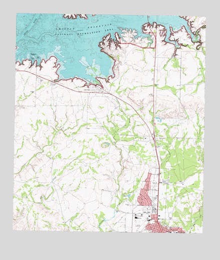
Del Rio NW, TX USGS Topographic Map
Click on map above to begin viewing in our Map Viewer.

This topographic map contains these locations and features:
Feature Name Type Latitude Longitude GNIS ID View Map
Black Brush PointCapeN29.4727°W100.9868°1330735View Map
Buena Vista Elementary SchoolSchoolN29.4082°W100.9193°2009059View Map
Buena Vista ParkParkN29.3966°W100.9182°2028690View Map
Cantu SpringSpringN29.3877°W100.9326°1998278View Map
Christ Bible Fellowship ChurchChurchN29.4016°W100.9154°2024364View Map
Del Rio Fire and Rescue Station 2BuildingN29.3917°W100.9081°2551353View Map
Del Rio Fire Department Fire Marshal's OfficeBuildingN29.3918°W100.9084°2552061View Map
Del Rio High SchoolSchoolN29.3835°W100.9199°2009006View Map
Del Rio Middle SchoolSchoolN29.3752°W100.8769°2009007View Map
Del Rio Ninth Grade CenterSchoolN29.3850°W100.9218°2009008View Map
Del Rio Police DepartmentBuildingN29.3834°W100.9030°2750534View Map
Del Rio Post OfficePost OfficeN29.3844°W100.9011°2767821View Map
Grace Lutheran ChurchChurchN29.3844°W100.9112°2024359View Map
Irene C Cardwell Elementary SchoolSchoolN29.3751°W100.8964°1334994View Map
KDLK-FM (Del Rio)TowerN29.4297°W100.9054°1385834View Map
KLKE-AM (Del Rio)TowerN29.4297°W100.9054°1385543View Map
Korean Presbyterian ChurchChurchN29.3844°W100.9087°2024362View Map
Lake ViewPopulated PlaceN29.4552°W100.9445°1339520View Map
Lake View Addition ColoniaPopulated PlaceN29.4572°W100.9473°2010770View Map
Lake View Census Designated PlaceCensusN29.4591°W100.9534°2408554View Map
Los Campos Number 1,2 and 5 ColoniaPopulated PlaceN29.4263°W100.9223°2010771View Map
Los Campos Number 3 and 4 ColoniaPopulated PlaceN29.4291°W100.9423°2010772View Map
Memorial Middle SchoolSchoolN29.3808°W100.9101°2009013View Map
Middle Fork San Pedro CreekStreamN29.4852°W100.8790°1341493View Map
North Heights Elementary SchoolSchoolN29.3821°W100.9106°1342752View Map
Northside Baptist ChurchChurchN29.4055°W100.9184°2024355View Map
San Felipe Del Rio Consolidated Independent School District Security / Police DepartmentBuildingN29.3855°W100.9235°2750404View Map
San Pedro Canyon (historical)ValleyN29.4919°W100.9484°1956149View Map
San Pedro CreekStreamN29.4927°W100.8795°1346445View Map
South Fork San Pedro CreekStreamN29.4802°W100.8951°1347459View Map
United States Border Patrol Del Rio Sector HeadquartersBuildingN29.3926°W100.8990°2750791View Map
Val Verde County Rural Volunteer Fire Department Station 4BuildingN29.4634°W100.9844°2551277View Map
Val Verde Regional Medical CenterHospitalN29.3751°W100.8924°1349146View Map

Note: Coordinates in the location and feature list above are referenced to NAD83 datum.


Copyright (C) 2008-2024 Ryan Niemi / Sunset Dynamics ... All Rights Reserved