TopoQuest Logo
Do you find TopoQuest useful?
Help keep TopoQuest running and adding new maps/features by donating!
Bitcoin:  19c7KJd3qBynnjoSw5npx9KScwjBe4ifkT
Litecoin:  LXs6TkuXGGXo1vDsWCkWVdjQX94eUKd6ui
Home View Maps Find Maps Find Places Resources & Links


Crater Lake, Montana Topographic Map

USGS Map Title: Crater Lake, MT
USGS Map MRC: 48113A8
DRG (GeoTIFF) Download: o48113a8.tif


Neighboring USGS Topographic Map Quads:


  Hash Mountain, MT  
48114B1
 

  Jewel Basin, MT  
48113B8
 

  Pioneer Ridge, MT  
48113B7
 

  Bigfork, MT  
48114A1
 

  Crater Lake, MT  
48113A8
 

  Big Hawk Mountain, MT  
48113A7
 

  Woods Bay, MT  
47114H1
 

  Yew Creek, MT  
47113H8
 

  Swan Lake, MT  
47113H7


Map MRC Location:

N49°
W114°
N49°
W113°
H8 H7 H6 H5 H4 H3 H2 H1
G8 G7 G6 G5 G4 G3 G2 G1
F8 F7 F6 F5 F4 F3 F2 F1
E8 E7 E6 E5 E4 E3 E2 E1
D8 D7 D6 D5 D4 D3 D2 D1
C8 C7 C6 C5 C4 C3 C2 C1
B8 B7 B6 B5 B4 B3 B2 B1
A8 A7 A6 A5 A4 A3 A2 A1
N48°
W114°
N48°
W113°

Crater Lake, MT USGS 1:24K Topographic Map Preview:
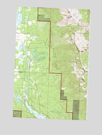
Crater Lake, MT USGS Topographic Map
Click on map above to begin viewing in our Map Viewer.

This topographic map contains these locations and features:
Feature Name Type Latitude Longitude GNIS ID View Map
26N19W11BBDD01 WellWellN48.0338°W113.9798°825689View Map
Bear CreekStreamN48.0761°W113.9798°779489View Map
Bear Creek VillagePopulated PlaceN48.0777°W113.9787°1795867View Map
Birch CreekStreamN48.1169°W113.9943°779929View Map
Broken Leg MountainSummitN48.0547°W113.8804°780424View Map
Crater LakeLakeN48.1170°W113.8997°781850View Map
Crater MountainSummitN48.1163°W113.9109°781853View Map
Deer CreekStreamN48.1100°W113.9909°782236View Map
Flathead ValleyFlatN48.0608°W113.9848°783521View Map
Horseshoe LakeLakeN48.0192°W113.9923°785076View Map
Horseshoe Lake - Ferndale Fishing Access SiteLocaleN48.0186°W113.9896°1744267View Map
Johnson CreekStreamN48.0216°W113.9793°785530View Map
Loon LakeLakeN48.0232°W113.9904°786561View Map
Loon Lake AccessLocaleN48.0258°W113.9907°794219View Map
Meadow CreekStreamN48.0572°W113.9732°787136View Map
Montana State Highway 83 Weigh StatonLocaleN48.0258°W113.9576°794220View Map
Mud LakeLakeN48.1121°W113.9948°787798View Map
Mud Lake (historical)Populated PlaceN48.1194°W113.9996°1795982View Map
Patterson CreekStreamN48.0583°W113.9759°788700View Map
Peterson CreekStreamN48.0650°W113.9746°788787View Map
Peterson Creek TrailTrailN48.0419°W113.8876°788789View Map
Rocky CreekStreamN48.1169°W113.9971°789727View Map
Schmidt CreekStreamN48.0102°W113.9284°790124View Map
Swan River Fishing Access SiteLocaleN48.0450°W113.9751°1744306View Map
Wolf CreekStreamN48.0819°W113.9893°793448View Map
Wolf Creek TrailTrailN48.1075°W113.9323°793457View Map

Note: Coordinates in the location and feature list above are referenced to NAD83 datum.


Copyright (C) 2008-2024 Ryan Niemi / Sunset Dynamics ... All Rights Reserved