TopoQuest Logo
Do you find TopoQuest useful?
Help keep TopoQuest running and adding new maps/features by donating!
Bitcoin:  19c7KJd3qBynnjoSw5npx9KScwjBe4ifkT
Litecoin:  LXs6TkuXGGXo1vDsWCkWVdjQX94eUKd6ui
Home View Maps Find Maps Find Places Resources & Links


Alpha, Idaho Topographic Map

USGS Map Title: Alpha, ID
USGS Map MRC: 44116D1
DRG (GeoTIFF) Download: o44116d1.tif


Neighboring USGS Topographic Map Quads:


  Cold Spring Ridge, ID  
44116E2
 

  Cascade, ID  
44116E1
 

  Eagle Nest, ID  
44115E8
 

  Tripod Peak, ID  
44116D2
 

  Alpha, ID  
44116D1
 

  Skunk Creek Summit, ID  
44115D8
 

  Sage Hen Reservoir, ID  
44116C2
 

  Smiths Ferry, ID  
44116C1
 

  Sixmile Point, ID  
44115C8


Map MRC Location:

N45°
W117°
N45°
W116°
H8 H7 H6 H5 H4 H3 H2 H1
G8 G7 G6 G5 G4 G3 G2 G1
F8 F7 F6 F5 F4 F3 F2 F1
E8 E7 E6 E5 E4 E3 E2 E1
D8 D7 D6 D5 D4 D3 D2 D1
C8 C7 C6 C5 C4 C3 C2 C1
B8 B7 B6 B5 B4 B3 B2 B1
A8 A7 A6 A5 A4 A3 A2 A1
N44°
W117°
N44°
W116°

Alpha, ID USGS 1:24K Topographic Map Preview:
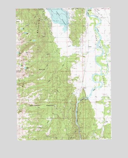
Alpha, ID USGS Topographic Map
Click on map above to begin viewing in our Map Viewer.

This topographic map contains these locations and features:
Feature Name Type Latitude Longitude GNIS ID View Map
AlphaPopulated PlaceN44.3910°W116.0079°396033View Map
BelviderePopulated PlaceN44.4754°W116.0335°396101View Map
Big CreekStreamN44.4368°W116.0110°377480View Map
Blue Lake TrailTrailN44.4266°W116.1187°377932View Map
Brush CreekStreamN44.4624°W116.0171°378327View Map
CabartonPopulated PlaceN44.4354°W116.0401°396204View Map
Cabarton StationLocaleN44.4243°W116.0393°394971View Map
Campbell Creek Recreation SiteLocaleN44.4993°W116.0851°394020View Map
Campbell Creek TrailTrailN44.4954°W116.1087°394055View Map
Cascade AirportAirportN44.4935°W116.0145°400778View Map
Cascade Rural Fire Protection District Station 2BuildingN44.4955°W116.0893°2619197View Map
Clear CreekStreamN44.4179°W116.0254°379397View Map
Collier PeakSummitN44.4691°W116.1135°379574View Map
Corral CreekStreamN44.4591°W116.0071°379785View Map
Fawn CreekStreamN44.3829°W116.0426°381620View Map
Grassy FlatFlatN44.3941°W116.0832°382575View Map
Hidden LakeLakeN44.4438°W116.1135°383151View Map
Hurdy CreekStreamN44.4224°W116.0471°396681View Map
Long ValleyValleyN44.4135°W116.0379°386096View Map
Lost LakeLakeN44.4463°W116.1197°386159View Map
Lower Alpha SchoolLocaleN44.3904°W116.0099°386211View Map
Moores CreekStreamN44.4752°W116.0529°387156View Map
Olson CreekStreamN44.4729°W116.0246°387953View Map
Pearsol CreekStreamN44.4993°W116.0254°388309View Map
Raft LakeLakeN44.4810°W116.1174°389022View Map
Skein LakeReservoirN44.4769°W116.1126°398717View Map
Skein Lake DamDamN44.4777°W116.1112°398716View Map
South Fork Fawn CreekStreamN44.3991°W116.0737°398154View Map
Stewarts MeadowFlatN44.4996°W116.1240°391456View Map
Willow CreekStreamN44.4952°W116.0621°393489View Map
Willow Creek ReservoirReservoirN44.4696°W116.1015°400492View Map
Willow Creek TrailTrailN44.4791°W116.1054°399654View Map

Note: Coordinates in the location and feature list above are referenced to NAD83 datum.


Copyright (C) 2008-2024 Ryan Niemi / Sunset Dynamics ... All Rights Reserved