TopoQuest Logo
Do you find TopoQuest useful?
Help keep TopoQuest running and adding new maps/features by donating!
Bitcoin:  19c7KJd3qBynnjoSw5npx9KScwjBe4ifkT
Litecoin:  LXs6TkuXGGXo1vDsWCkWVdjQX94eUKd6ui
Home View Maps Find Maps Find Places Resources & Links


Alma, Nebraska Topographic Map

USGS Map Title: Alma, NE
USGS Map MRC: 40099A3
DRG (GeoTIFF) Download: o40099a3.tif


Neighboring USGS Topographic Map Quads:


  Orleans, NE  
40099B4
 

  Huntley, NE  
40099B3
 

  Republican City NW, NE  
40099B2
 

  Alma SW, NE  
40099A4
 

  Alma, NE  
40099A3
 

  Republican City, NE  
40099A2
 

  Woodruff, KS  
39099H4
 

  Stuttgart NE, KS  
39099H3
 

  Kensington NW, KS  
39099H2


Map MRC Location:

N41°
W100°
N41°
W99°
H8 H7 H6 H5 H4 H3 H2 H1
G8 G7 G6 G5 G4 G3 G2 G1
F8 F7 F6 F5 F4 F3 F2 F1
E8 E7 E6 E5 E4 E3 E2 E1
D8 D7 D6 D5 D4 D3 D2 D1
C8 C7 C6 C5 C4 C3 C2 C1
B8 B7 B6 B5 B4 B3 B2 B1
A8 A7 A6 A5 A4 A3 A2 A1
N40°
W100°
N40°
W99°

Alma, NE USGS 1:24K Topographic Map Preview:
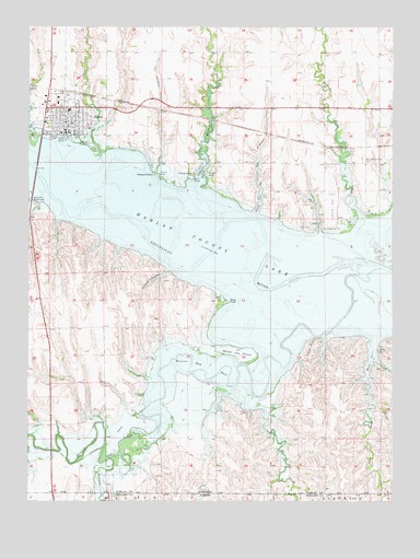
Alma, NE USGS Topographic Map
Click on map above to begin viewing in our Map Viewer.

This topographic map contains these locations and features:
Feature Name Type Latitude Longitude GNIS ID View Map
Agri Co-op ElevatorLocaleN40.1075°W99.3623°1875590View Map
AlmaPopulated PlaceN40.0975°W99.3620°826967View Map
AlmaLocaleN40.1081°W99.3629°1875581View Map
Alma City ParkParkN40.0986°W99.3687°1875599View Map
Alma Dental ClinicHospitalN40.0967°W99.3618°1875588View Map
Alma Evangelical Free ChurchChurchN40.0972°W99.3670°1875596View Map
Alma Municipal AirportAirportN40.1118°W99.3474°837468View Map
Alma Municipal Golf CourseLocaleN40.0995°W99.3737°1875597View Map
Alma Post OfficePost OfficeN40.0982°W99.3631°1875589View Map
Alma Public SchoolsSchoolN40.1031°W99.3615°1875598View Map
Alma Vista Picnic AreaParkN40.0786°W99.3732°826969View Map
Alma Volunteer Fire DepartmentBuildingN40.0972°W99.3602°2553356View Map
Boat RampLocaleN40.0850°W99.3187°827523View Map
Bone CoveBayN40.0372°W99.2576°827557View Map
Bone CreekStreamN40.0288°W99.2586°471781View Map
City of AlmaCivilN40.1012°W99.3657°837849View Map
City of Alma Trailer ParkLocaleN40.0983°W99.3687°1875600View Map
Colonial Villa Good Samaritan CenterHospitalN40.1050°W99.3654°1875585View Map
Cook CreekStreamN40.0917°W99.3512°828309View Map
Coyote CanyonValleyN40.0603°W99.3284°828425View Map
Crystal CreekStreamN40.0214°W99.2929°828498View Map
First Christian ChurchChurchN40.0997°W99.3604°1875594View Map
Free Methodist ChurchChurchN40.1025°W99.3582°1875592View Map
Harlan County Court HouseBuildingN40.0997°W99.3629°1875583View Map
Harlan County Health SystemHospitalN40.1051°W99.3653°1875586View Map
Harlan County LakeReservoirN40.0631°W99.2906°471770View Map
Harlan County Lake Recreation AreaParkN40.0583°W99.3087°1875547View Map
Harlan County Lake Seaplane BaseAirportN40.0431°W99.2512°837469View Map
Harlan County Medical ClinicHospitalN40.1050°W99.3654°1875587View Map
Harlan County SheriffBuildingN40.0993°W99.3624°1875582View Map
Hoesch Memorial LibraryBuildingN40.0995°W99.3690°1875584View Map
Indian HillSummitN40.0395°W99.2784°830278View Map
Methodist CoveBayN40.0870°W99.3159°831245View Map
Methodist Cove CampgroundLocaleN40.0864°W99.3195°1875546View Map
Methodist CreekStreamN40.0895°W99.3140°831246View Map
Mill CreekStreamN40.0761°W99.2615°831303View Map
North CoveBayN40.0739°W99.2756°831680View Map
North Cove CampgroundLocaleN40.0731°W99.2743°1875545View Map
Peace Lutheran ChurchChurchN40.1008°W99.3693°1875593View Map
Pheasant PointCapeN40.0864°W99.3326°832071View Map
Prairie Dog BayStreamN40.0342°W99.3157°832356View Map
Prairie Dog CreekStreamN40.0614°W99.2537°471909View Map
Republican City CemeteryCemeteryN40.0906°W99.2609°832523View Map
Saint Joseph Catholic ChurchChurchN40.1014°W99.3645°1875595View Map
Sindt PointCapeN40.0528°W99.3087°833461View Map
Tipover CoveBayN40.0786°W99.2962°834120View Map
Tipover CreekStreamN40.0831°W99.2965°834121View Map
Township of Prairie DogCivilN40.0455°W99.3484°838201View Map
United Methodist ChurchChurchN40.0997°W99.3618°1875591View Map
Walnut CreekStreamN40.0114°W99.3470°471779View Map
White Cat PointCapeN40.0389°W99.3020°834672View Map

Note: Coordinates in the location and feature list above are referenced to NAD83 datum.


Copyright (C) 2008-2024 Ryan Niemi / Sunset Dynamics ... All Rights Reserved