TopoQuest Logo
Do you find TopoQuest useful?
Help keep TopoQuest running and adding new maps/features by donating!
Bitcoin:  19c7KJd3qBynnjoSw5npx9KScwjBe4ifkT
Litecoin:  LXs6TkuXGGXo1vDsWCkWVdjQX94eUKd6ui
Home View Maps Find Maps Find Places Resources & Links


Bug Scuffle Canyon, New Mexico Topographic Map

USGS Map Title: Bug Scuffle Canyon, NM
USGS Map MRC: 32105F7
DRG (GeoTIFF) Download: o32105f7.tif


Neighboring USGS Topographic Map Quads:


  Alamogordo South, NM  
32105G8
 

  Sacramento Peak, NM  
32105G7
 

  Bluff Springs, NM  
32105G6
 

  Deadman Canyon, NM  
32105F8
 

  Bug Scuffle Canyon, NM  
32105F7
 

  Rogers Ruins, NM  
32105F6


  Culp Canyon, NM  
32105E7
 

  El Paso Canyon, NM  
32105E6


Map MRC Location:

N33°
W106°
N33°
W105°
H8 H7 H6 H5 H4 H3 H2 H1
G8 G7 G6 G5 G4 G3 G2 G1
F8 F7 F6 F5 F4 F3 F2 F1
E8 E7 E6 E5 E4 E3 E2 E1
D8 D7 D6 D5 D4 D3 D2 D1
C8 C7 C6 C5 C4 C3 C2 C1
B8 B7 B6 B5 B4 B3 B2 B1
A8 A7 A6 A5 A4 A3 A2 A1
N32°
W106°
N32°
W105°

Bug Scuffle Canyon, NM USGS 1:24K Topographic Map Preview:
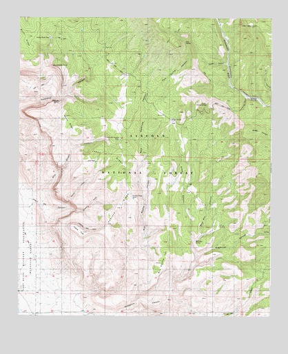
Bug Scuffle Canyon, NM USGS Topographic Map
Click on map above to begin viewing in our Map Viewer.

This topographic map contains these locations and features:
Feature Name Type Latitude Longitude GNIS ID View Map
Bug Scuffle CanyonValleyN32.6357°W105.8447°904165View Map
Bug Scuffle HillSummitN32.6473°W105.8066°904166View Map
Burnt RidgeRidgeN32.7404°W105.8725°904226View Map
Corner Dry Pasture TankReservoirN32.6991°W105.8254°913211View Map
Danley CanyonValleyN32.7304°W105.7728°905590View Map
Dripping SpringSpringN32.7153°W105.8558°913218View Map
Ellis Wright CanyonValleyN32.6773°W105.8705°906140View Map
Gobbler KnobSummitN32.7301°W105.8575°913223View Map
Grapevine CanyonValleyN32.6262°W105.8405°906701View Map
Hornbuckle CanyonValleyN32.7168°W105.7616°913210View Map
Jake TankReservoirN32.6898°W105.8358°913212View Map
Jakes RidgeRidgeN32.6931°W105.8330°907303View Map
Little Cherry SpringSpringN32.7135°W105.7826°913221View Map
McCracken CanyonValleyN32.6468°W105.7878°908500View Map
McCracken RanchLocaleN32.6584°W105.7858°908501View Map
Moore RidgeRidgeN32.7062°W105.8530°908890View Map
Moore TankReservoirN32.7087°W105.8439°913219View Map
North Fork Negro Ed CanyonValleyN32.6704°W105.8516°913213View Map
Pasture RidgeRidgeN32.6715°W105.8247°913229View Map
Pasture Ridge TankReservoirN32.6744°W105.8185°913230View Map
Pine SpringSpringN32.7481°W105.7933°913217View Map
Pine Spring CanyonValleyN32.7154°W105.8136°909681View Map
Rock Waterhole CanyonValleyN32.6737°W105.8133°910401View Map
Sacramento Lookout TowerTowerN32.7468°W105.7608°929034View Map
Sacramento Side CampLocaleN32.7173°W105.7611°910507View Map
Snaky CanyonValleyN32.6515°W105.7878°910972View Map
South Fork Negro Ed CanyonValleyN32.6690°W105.8425°913214View Map
Table TopSummitN32.6601°W105.8428°913215View Map
Turkey Roost TankReservoirN32.7416°W105.8599°913216View Map
Wild Boy CanyonValleyN32.6562°W105.7894°912366View Map
Wild Boy SpringSpringN32.6570°W105.7872°913231View Map
Wright SpringSpringN32.7069°W105.7996°913220View Map

Note: Coordinates in the location and feature list above are referenced to NAD83 datum.


Copyright (C) 2008-2024 Ryan Niemi / Sunset Dynamics ... All Rights Reserved