TopoQuest Logo
Do you find TopoQuest useful?
Help keep TopoQuest running and adding new maps/features by donating!
Bitcoin:  19c7KJd3qBynnjoSw5npx9KScwjBe4ifkT
Litecoin:  LXs6TkuXGGXo1vDsWCkWVdjQX94eUKd6ui
Home View Maps Find Maps Find Places Resources & Links


Browns Summit, North Carolina Topographic Map

USGS Map Title: Browns Summit, NC
USGS Map MRC: 36079B6
DRG (GeoTIFF) Download: o36079b6.tif


Neighboring USGS Topographic Map Quads:


  Bethany, NC  
36079C7
 

  Reidsville, NC  
36079C6
 

  Williamsburg, NC  
36079C5
 

  Lake Brandt, NC  
36079B7
 

  Browns Summit, NC  
36079B6
 

  Ossipee, NC  
36079B5
 

  Greensboro, NC  
36079A7
 

  McLeansville, NC  
36079A6
 

  Gibsonville, NC  
36079A5


Map MRC Location:

N37°
W80°
N37°
W79°
H8 H7 H6 H5 H4 H3 H2 H1
G8 G7 G6 G5 G4 G3 G2 G1
F8 F7 F6 F5 F4 F3 F2 F1
E8 E7 E6 E5 E4 E3 E2 E1
D8 D7 D6 D5 D4 D3 D2 D1
C8 C7 C6 C5 C4 C3 C2 C1
B8 B7 B6 B5 B4 B3 B2 B1
A8 A7 A6 A5 A4 A3 A2 A1
N36°
W80°
N36°
W79°

Browns Summit, NC USGS 1:24K Topographic Map Preview:
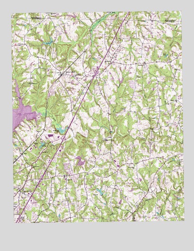
Browns Summit, NC USGS Topographic Map
Click on map above to begin viewing in our Map Viewer.

This topographic map contains these locations and features:
Feature Name Type Latitude Longitude GNIS ID View Map
Ames LakeReservoirN36.2151°W79.6414°1000354View Map
Ames Lake DamDamN36.2151°W79.6414°1000353View Map
Apple PondReservoirN36.2234°W79.6364°980259View Map
BenajaPopulated PlaceN36.2499°W79.6773°1006128View Map
Blackwood CreekStreamN36.1415°W79.6356°981570View Map
Brooks LakeReservoirN36.2325°W79.7224°981980View Map
Browns SummitPopulated PlaceN36.2126°W79.7136°982041View Map
Browns Summit Post OfficePost OfficeN36.2116°W79.7140°2774248View Map
Browns Summit SchoolSchoolN36.2107°W79.7023°982042View Map
Camp HermanLocaleN36.1721°W79.7309°982535View Map
Fair Grove ChurchChurchN36.2499°W79.7228°984892View Map
Fellowship HallBuildingN36.1480°W79.7283°2701547View Map
Fire District 13 Station 55 GreensboroBuildingN36.1532°W79.7132°2638907View Map
Friendship ChurchChurchN36.2187°W79.6528°985456View Map
Green Hall CemeteryCemeteryN36.1504°W79.7103°986057View Map
Hardys Mill PondReservoirN36.1802°W79.7138°986402View Map
Hardys Mill Pond DamDamN36.1818°W79.7095°1000275View Map
Herman ChurchChurchN36.1671°W79.7286°986641View Map
Hines ChapelChurchN36.1737°W79.6834°986843View Map
Holiness ChurchChurchN36.2079°W79.7359°986923View Map
Jackson ChurchChurchN36.2110°W79.6584°987490View Map
Johnson ChurchChurchN36.1971°W79.6292°987668View Map
Katie BranchStreamN36.1765°W79.6320°987876View Map
Lake Brooks DamDamN36.2335°W79.7198°1000393View Map
Lake HermanReservoirN36.1715°W79.7285°986644View Map
Lake Herman DamDamN36.1724°W79.7264°1000254View Map
Lakeview Memorial ParkCemeteryN36.1274°W79.7447°988100View Map
LakewoodPopulated PlaceN36.1412°W79.6945°1021087View Map
Lakewood LakeReservoirN36.1434°W79.6864°1000166View Map
Lakewood Lake DamDamN36.1418°W79.6848°1000165View Map
Lebanon ChurchChurchN36.1529°W79.7125°988270View Map
Locust Grove ChurchChurchN36.2126°W79.7048°988845View Map
Madison Elementary SchoolSchoolN36.1468°W79.6953°1006605View Map
MonticelloPopulated PlaceN36.2193°W79.6778°990156View Map
Monticello Elementary SchoolSchoolN36.2193°W79.6775°1006608View Map
North Buffalo CreekStreamN36.1282°W79.6622°991200View Map
Northeast Guilford Volunteer Fire Department Station 32BuildingN36.2096°W79.6583°2638951View Map
Northeast Junior High SchoolSchoolN36.1612°W79.6748°1006606View Map
Northeast Senior High SchoolSchoolN36.1585°W79.6725°1006607View Map
Phibbs CemeteryCemeteryN36.2318°W79.7453°992120View Map
Poplar Grove SchoolSchoolN36.1585°W79.7359°992693View Map
Rocky BranchStreamN36.1801°W79.6486°993566View Map
RuddPopulated PlaceN36.1660°W79.7428°993796View Map
Smith BranchStreamN36.1821°W79.6728°994934View Map
Smothers LakeReservoirN36.2102°W79.6758°1000336View Map
Smothers Lake DamDamN36.2101°W79.6748°1000335View Map
South Buffalo CreekStreamN36.1279°W79.6622°995131View Map
Squirrel CreekStreamN36.1896°W79.7459°995386View Map
Townsend DamDamN36.1901°W79.7331°1000298View Map
Township of MadisonCivilN36.1920°W79.6593°1026741View Map
Township of MonroeCivilN36.2214°W79.7209°1026742View Map
Union Grove ChurchChurchN36.1574°W79.6611°996491View Map
White Oak Grove ChurchChurchN36.1432°W79.7431°997178View Map
WRDG-TV (Burlington)TowerN36.1807°W79.6397°1018606View Map
WWMO-FM (Reidsville)TowerN36.2224°W79.6961°1018340View Map

Note: Coordinates in the location and feature list above are referenced to NAD83 datum.


Copyright (C) 2008-2024 Ryan Niemi / Sunset Dynamics ... All Rights Reserved