TopoQuest Logo
Do you find TopoQuest useful?
Help keep TopoQuest running and adding new maps/features by donating!
Bitcoin:  19c7KJd3qBynnjoSw5npx9KScwjBe4ifkT
Litecoin:  LXs6TkuXGGXo1vDsWCkWVdjQX94eUKd6ui
Home View Maps Find Maps Find Places Resources & Links


Breese, Illinois Topographic Map

USGS Map Title: Breese, IL
USGS Map MRC: 38089E5
DRG (GeoTIFF) Download: o38089e5.tif


Neighboring USGS Topographic Map Quads:


  Highland, IL  
38089F6
 

  Saint Rose, IL  
38089F5
 

  Stolletown, IL  
38089F4
 

  Trenton, IL  
38089E6
 

  Breese, IL  
38089E5
 

  Beckemeyer, IL  
38089E4
 

  Venedy, IL  
38089D6
 

  Okawville, IL  
38089D5
 

  Addieville, IL  
38089D4


Map MRC Location:

N39°
W90°
N39°
W89°
H8 H7 H6 H5 H4 H3 H2 H1
G8 G7 G6 G5 G4 G3 G2 G1
F8 F7 F6 F5 F4 F3 F2 F1
E8 E7 E6 E5 E4 E3 E2 E1
D8 D7 D6 D5 D4 D3 D2 D1
C8 C7 C6 C5 C4 C3 C2 C1
B8 B7 B6 B5 B4 B3 B2 B1
A8 A7 A6 A5 A4 A3 A2 A1
N38°
W90°
N38°
W89°

Breese, IL USGS 1:24K Topographic Map Preview:
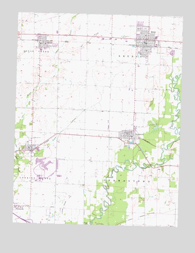
Breese, IL USGS Topographic Map
Click on map above to begin viewing in our Map Viewer.

This topographic map contains these locations and features:
Feature Name Type Latitude Longitude GNIS ID View Map
AlbersPopulated PlaceN38.5434°W89.6123°403378View Map
Albers Elementary SchoolSchoolN38.5450°W89.6143°1810411View Map
Albers Post OfficePost OfficeN38.5443°W89.6137°1968135View Map
Ammons CemeteryCemeteryN38.5128°W89.5087°1965750View Map
Arentsen Dairy FarmLocaleN38.5628°W89.5275°2706179View Map
AvistonPopulated PlaceN38.6067°W89.6076°403760View Map
Aviston Elementary SchoolSchoolN38.6070°W89.6076°1810412View Map
Aviston Fire Protection DistrictBuildingN38.6081°W89.6112°2640870View Map
Aviston Post OfficePost OfficeN38.6074°W89.6059°2788626View Map
Behrmann Hog FarmLocaleN38.5822°W89.6133°2706245View Map
BreesePopulated PlaceN38.6106°W89.5270°404809View Map
Breese Ambulance ServiceBuildingN38.6081°W89.5301°2640355View Map
Breese Elementary SchoolSchoolN38.6134°W89.5281°1810417View Map
Breese Police DepartmentBuildingN38.6075°W89.5286°2758844View Map
Breese Post OfficePost OfficeN38.6090°W89.5286°1968151View Map
Breese Volunteer Fire Protection DistrictBuildingN38.6076°W89.5348°2640285View Map
Bruns Dairy FarmLocaleN38.5733°W89.5450°2706180View Map
Bull BranchStreamN38.6053°W89.5906°405173View Map
Central Community High SchoolSchoolN38.6106°W89.5604°1810421View Map
City of BreeseCivilN38.6139°W89.5231°2393409View Map
Clin - Clair Volunteer Fire Protection DistrictBuildingN38.5430°W89.6163°2640520View Map
Dall DairyLocaleN38.5817°W89.6022°2706246View Map
DamiansvillePopulated PlaceN38.5100°W89.6195°406935View Map
Damiansville Elementary SchoolSchoolN38.5095°W89.6231°1810425View Map
Endres School (historical)SchoolN38.5823°W89.5718°1736387View Map
GermantownPopulated PlaceN38.5537°W89.5384°408974View Map
Germantown Egg FarmLocaleN38.5692°W89.5514°2706181View Map
Germantown Elementary SchoolSchoolN38.5531°W89.5379°1810433View Map
Germantown Police DepartmentBuildingN38.5534°W89.5399°2759074View Map
Germantown Post OfficePost OfficeN38.5543°W89.5388°1968129View Map
Germantown Public LibraryBuildingN38.5539°W89.5390°1968130View Map
Germantown Rural Fire Protection DistrictBuildingN38.5531°W89.5395°2640519View Map
Grassy BranchStreamN38.5295°W89.6220°409329View Map
Hanover Drainage DitchCanalN38.5067°W89.5245°409752View Map
Heimanns LeveeLeveeN38.5053°W89.5715°410033View Map
Hollenkamp FarmLocaleN38.5814°W89.5733°2706182View Map
Interchange 34CrossingN38.5003°W89.6118°1810439View Map
Jansen Dairy FarmLocaleN38.5556°W89.6064°2706183View Map
Kordair FarmsLocaleN38.5608°W89.5797°2706184View Map
Lake BranchStreamN38.5373°W89.6220°411703View Map
Mater Dei High SchoolSchoolN38.6159°W89.5329°413117View Map
Maue FarmsLocaleN38.5800°W89.5378°2706202View Map
Mescher School (historical)SchoolN38.5289°W89.5076°1736405View Map
Pingsterhaus FarmsLocaleN38.5628°W89.5919°2706185View Map
Saint Augustine Catholic ChurchChurchN38.6045°W89.5281°1968149View Map
Saint Bernard CemeteryCemeteryN38.5509°W89.6118°417206View Map
Saint Bernards ChurchChurchN38.5448°W89.6137°1968137View Map
Saint Boniface CemeteryCemeteryN38.5509°W89.5392°1965753View Map
Saint Boniface ChurchChurchN38.5537°W89.5379°1968162View Map
Saint Damian ChurchChurchN38.5098°W89.6237°1968160View Map
Saint Dominic - Saint Augustine CemeteryCemeteryN38.6121°W89.5406°417257View Map
Saint Francis CemeteryCemeteryN38.6042°W89.6112°1965763View Map
Saint Francis ChurchChurchN38.6064°W89.6076°1968161View Map
Saint John CemeteryCemeteryN38.6184°W89.5356°417370View Map
Sentel School (historical)SchoolN38.5528°W89.5723°1736415View Map
Spihlmann FarmsLocaleN38.5300°W89.5725°2706186View Map
Sycamore Drainage DitchCanalN38.5056°W89.5868°419502View Map
Township of BreeseCivilN38.6109°W89.5367°428705View Map
Township of GermantownCivilN38.5218°W89.5357°429050View Map
Tri-County Feed MillLocaleN38.6044°W89.6092°2706248View Map
Village of AlbersCivilN38.5452°W89.6143°2397924View Map
Village of AvistonCivilN38.6091°W89.6048°2398011View Map
Village of DamiansvilleCivilN38.5088°W89.6150°2398675View Map
Village of GermantownCivilN38.5552°W89.5413°2398955View Map
Voss DairyLocaleN38.5600°W89.5367°2706187View Map

Note: Coordinates in the location and feature list above are referenced to NAD83 datum.


Copyright (C) 2008-2024 Ryan Niemi / Sunset Dynamics ... All Rights Reserved