TopoQuest Logo
Do you find TopoQuest useful?
Help keep TopoQuest running and adding new maps/features by donating!
Bitcoin:  19c7KJd3qBynnjoSw5npx9KScwjBe4ifkT
Litecoin:  LXs6TkuXGGXo1vDsWCkWVdjQX94eUKd6ui
Home View Maps Find Maps Find Places Resources & Links


Wright, Minnesota Topographic Map

USGS Map Title: Wright, MN
USGS Map MRC: 46093F1
DRG (GeoTIFF) Download: o46093f1.tif


Neighboring USGS Topographic Map Quads:


  Balsam, MN  
46093G2
 

  Little Prairie Lake, MN  
46093G1
 

  Prairie Lake, MN  
46092G8
 

  Tamarack, MN  
46093F2
 

  Wright, MN  
46093F1
 

  Cromwell West, MN  
46092F8
 

  Lawler, MN  
46093E2
 

  Automba, MN  
46093E1
 

  Heikkila Creek, MN  
46092E8


Map MRC Location:

N47°
W94°
N47°
W93°
H8 H7 H6 H5 H4 H3 H2 H1
G8 G7 G6 G5 G4 G3 G2 G1
F8 F7 F6 F5 F4 F3 F2 F1
E8 E7 E6 E5 E4 E3 E2 E1
D8 D7 D6 D5 D4 D3 D2 D1
C8 C7 C6 C5 C4 C3 C2 C1
B8 B7 B6 B5 B4 B3 B2 B1
A8 A7 A6 A5 A4 A3 A2 A1
N46°
W94°
N46°
W93°

Wright, MN USGS 1:24K Topographic Map Preview:
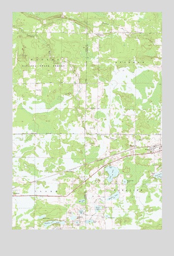
Wright, MN USGS Topographic Map
Click on map above to begin viewing in our Map Viewer.

This topographic map contains these locations and features:
Feature Name Type Latitude Longitude GNIS ID View Map
Bone LakeLakeN46.6291°W93.0709°640363View Map
City of TamarackCivilN46.6530°W93.1250°2396028View Map
City of WrightCivilN46.6725°W93.0069°2397381View Map
Cole LakeLakeN46.6576°W93.0418°641389View Map
Cranberry LakeLakeN46.6317°W93.0742°642417View Map
Douglas LakeLakeN46.6287°W93.0909°642906View Map
Kettle LakeLakeN46.6296°W93.0609°646125View Map
Lakeside CemeteryCemeteryN46.6377°W93.0477°646422View Map
Lakeview CemeteryCemeteryN46.6683°W93.0005°2074160View Map
Little LakeLakeN46.6344°W93.0749°646835View Map
Little Tamarack RiverStreamN46.7369°W93.1055°646950View Map
Louma LakeLakeN46.6353°W93.0676°647229View Map
Mattlia LakeLakeN46.6440°W93.0402°647618View Map
Mud LakeLakeN46.6414°W93.0669°648307View Map
School LakeLakeN46.6328°W93.0460°651320View Map
Section One LakeLakeN46.6526°W93.0313°651832View Map
Spruce LakeLakeN46.6321°W93.1005°652507View Map
Township of BesemanCivilN46.7231°W93.0001°663579View Map
Township of LakeviewCivilN46.6348°W93.0005°664709View Map
Walli LakeLakeN46.6371°W93.0538°653739View Map
WrightPopulated PlaceN46.6691°W93.0069°654393View Map
WrightLocaleN46.6728°W93.0083°2073855View Map
Wright Catholic CemeteryCemeteryN46.6703°W93.0086°2074162View Map
Wright Community CemeteryCemeteryN46.6742°W93.0017°2074161View Map
Wright Post OfficePost OfficeN46.6727°W93.0016°2073856View Map
Wright Volunteer Fire DepartmentBuildingN46.6702°W93.0067°2666442View Map

Note: Coordinates in the location and feature list above are referenced to NAD83 datum.


Copyright (C) 2008-2024 Ryan Niemi / Sunset Dynamics ... All Rights Reserved