TopoQuest Logo
Do you find TopoQuest useful?
Help keep TopoQuest running and adding new maps/features by donating!
Bitcoin:  19c7KJd3qBynnjoSw5npx9KScwjBe4ifkT
Litecoin:  LXs6TkuXGGXo1vDsWCkWVdjQX94eUKd6ui
Home View Maps Find Maps Find Places Resources & Links


Williamsville, Virginia Topographic Map

USGS Map Title: Williamsville, VA
USGS Map MRC: 38079B5
DRG (GeoTIFF) Download: o38079b5.tif


Neighboring USGS Topographic Map Quads:


  Mustoe, VA  
38079C6
 

  Monterey SE, VA  
38079C5
 

  McDowell, VA  
38079C4
 

  Burnsville, VA  
38079B6
 

  Williamsville, VA  
38079B5
 

  Deerfield, VA  
38079B4
 

  Bath Alum, VA  
38079A6
 

  Green Valley, VA  
38079A5
 

  Craigsville, VA  
38079A4


Map MRC Location:

N39°
W80°
N39°
W79°
H8 H7 H6 H5 H4 H3 H2 H1
G8 G7 G6 G5 G4 G3 G2 G1
F8 F7 F6 F5 F4 F3 F2 F1
E8 E7 E6 E5 E4 E3 E2 E1
D8 D7 D6 D5 D4 D3 D2 D1
C8 C7 C6 C5 C4 C3 C2 C1
B8 B7 B6 B5 B4 B3 B2 B1
A8 A7 A6 A5 A4 A3 A2 A1
N38°
W80°
N38°
W79°

Williamsville, VA USGS 1:24K Topographic Map Preview:
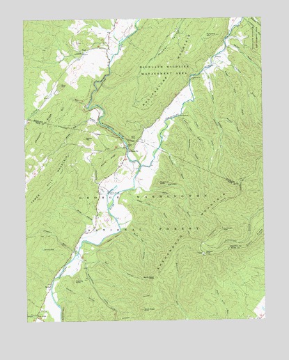
Williamsville, VA USGS Topographic Map
Click on map above to begin viewing in our Map Viewer.

This topographic map contains these locations and features:
Feature Name Type Latitude Longitude GNIS ID View Map
Alum RockSummitN38.2101°W79.5409°1499051View Map
Barracks DraftValleyN38.1959°W79.5529°1481473View Map
Bath - Highland Volunteer Fire DepartmentBuildingN38.2003°W79.5646°2086345View Map
Browns PondLakeN38.1550°W79.6160°1482045View Map
Brushy ForkStreamN38.2290°W79.5298°1482061View Map
Buck Lick HollowValleyN38.1633°W79.5721°1482114View Map
Bullpasture GorgeValleyN38.1958°W79.5706°1482163View Map
Bullpasture RiverStreamN38.1896°W79.5637°1482164View Map
Bullpasture RiverStreamN38.1896°W79.5637°1550556View Map
Byrd PointCliffN38.1982°W79.5684°1482202View Map
Campbell RunStreamN38.1526°W79.5987°1482290View Map
Chesnut RidgeRidgeN38.1982°W79.6181°1487037View Map
Coursey Springs State Fish HatcheryLocaleN38.1787°W79.5812°1482731View Map
FloodLocaleN38.2362°W79.5928°1483465View Map
Flood School (historical)SchoolN38.2407°W79.5870°1673768View Map
Fort LewisPopulated PlaceN38.1271°W79.6198°1499436View Map
Foxtail HollowValleyN38.1371°W79.6080°1483520View Map
Hulit DraftStreamN38.2071°W79.5395°1488597View Map
Hupman ValleyValleyN38.2259°W79.5651°1484292View Map
Hupman Valley TrailTrailN38.2473°W79.5412°1488522View Map
Jerkemtight TrailTrailN38.2029°W79.5214°1484424View Map
Knox Lick DraftValleyN38.2100°W79.5428°1484631View Map
Laurel Gap ChurchChurchN38.2260°W79.5367°1484708View Map
Lick DraftValleyN38.2317°W79.5180°1484820View Map
Lockridge Memorial ChurchChurchN38.2360°W79.5937°1485012View Map
Marshall DraftValleyN38.1789°W79.5602°1485196View Map
Marshall Draft TrailTrailN38.1712°W79.5428°1485197View Map
McCrays DraftValleyN38.2072°W79.5460°1485278View Map
Meadow KnobSummitN38.1415°W79.5989°1485343View Map
Mill RunStreamN38.2137°W79.5909°1485454View Map
Mount Zion ChurchChurchN38.2407°W79.5828°1485667View Map
Nelson DraftValleyN38.2386°W79.5167°1485824View Map
North Sister KnobSummitN38.1432°W79.5573°1485921View Map
Northeast PeakSummitN38.1626°W79.5212°1485922View Map
PatnaPopulated PlaceN38.2337°W79.5239°1499846View Map
Persimmon Pond (historical)LakeN38.1579°W79.6145°1673654View Map
Pheasanty RunStreamN38.1773°W79.5812°1486174View Map
Poplar HollowValleyN38.1288°W79.6136°1486357View Map
Rail HollowValleyN38.1501°W79.5875°1486486View Map
Ratcliff HillSummitN38.1296°W79.6053°1499935View Map
Rock HillSummitN38.1607°W79.5750°1499978View Map
Round HillSummitN38.2004°W79.5923°1486785View Map
Scotchtown DraftValleyN38.1507°W79.5958°1486967View Map
Shanty RidgeRidgeN38.1912°W79.5800°1487147View Map
Short RidgeRidgeN38.1579°W79.5045°1487223View Map
Sinking CreekStreamN38.2221°W79.6053°1487261View Map
Slaty Lick DraftValleyN38.1791°W79.5705°1487307View Map
South Sister KnobSummitN38.1296°W79.5637°1487422View Map
Sugar Tree DraftValleyN38.2295°W79.5213°1487700View Map
Sugarloaf KnobSummitN38.1818°W79.5545°1487705View Map
Summers MountainSummitN38.2454°W79.5328°1487729View Map
Wallace PeakSummitN38.1526°W79.5320°1488167View Map
Water SinksBasinN38.2218°W79.6050°1488205View Map
White Oak DraftValleyN38.2073°W79.5853°1488293View Map
Wide HollowValleyN38.1660°W79.5886°1488352View Map
Wide HollowValleyN38.2271°W79.5296°1488353View Map
WilliamsvillePopulated PlaceN38.1948°W79.5709°1500323View Map
Williamsville Elementary School (historical)SchoolN38.1893°W79.5753°1673661View Map
Williamsville Post OfficePost OfficeN38.2003°W79.5646°2766435View Map

Note: Coordinates in the location and feature list above are referenced to NAD83 datum.


Copyright (C) 2008-2024 Ryan Niemi / Sunset Dynamics ... All Rights Reserved