TopoQuest Logo
Do you find TopoQuest useful?
Help keep TopoQuest running and adding new maps/features by donating!
Bitcoin:  19c7KJd3qBynnjoSw5npx9KScwjBe4ifkT
Litecoin:  LXs6TkuXGGXo1vDsWCkWVdjQX94eUKd6ui
Home View Maps Find Maps Find Places Resources & Links


Willard, Utah Topographic Map

USGS Map Title: Willard, UT
USGS Map MRC: 41112D1
DRG (GeoTIFF) Download: o41112d1.tif


Neighboring USGS Topographic Map Quads:


  Brigham City, UT  
41112E1
 

  Mount Pisgah, UT  
41111E8
 

  Whistler Canal, UT  
41112D2
 

  Willard, UT  
41112D1
 

  Mantua, UT  
41111D8
 

  Plain City SW, UT  
41112C2
 

  Plain City, UT  
41112C1
 

  North Ogden, UT  
41111C8


Map MRC Location:

N42°
W113°
N42°
W112°
H8 H7 H6 H5 H4 H3 H2 H1
G8 G7 G6 G5 G4 G3 G2 G1
F8 F7 F6 F5 F4 F3 F2 F1
E8 E7 E6 E5 E4 E3 E2 E1
D8 D7 D6 D5 D4 D3 D2 D1
C8 C7 C6 C5 C4 C3 C2 C1
B8 B7 B6 B5 B4 B3 B2 B1
A8 A7 A6 A5 A4 A3 A2 A1
N41°
W113°
N41°
W112°

Willard, UT USGS 1:24K Topographic Map Preview:
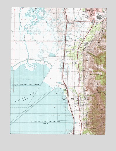
Willard, UT USGS Topographic Map
Click on map above to begin viewing in our Map Viewer.

This topographic map contains these locations and features:
Feature Name Type Latitude Longitude GNIS ID View Map
Aldersgate United Methodist ChurchChurchN41.4952°W112.0222°1449216View Map
Arthur V Watkins DamDamN41.3752°W112.1202°1448087View Map
Black SloughStreamN41.4713°W112.0830°1438878View Map
Brigham City Bible ChurchChurchN41.4974°W112.0133°1448181View Map
Brigham City Community HospitalHospitalN41.4911°W112.0259°1448183View Map
Brigham City Community Hospital HeliportAirportN41.4899°W112.0224°1448184View Map
Brigham City DivisionCivilN41.4431°W112.0810°1939351View Map
Brigham City Shopping CenterLocaleN41.4866°W112.0163°1455195View Map
Christian Reformed ChurchChurchN41.4977°W112.0111°1449237View Map
City of PerryCivilN41.4648°W112.0401°2411405View Map
City of WillardCivilN41.4146°W112.0447°2412265View Map
Cook CanyonValleyN41.4016°W112.0227°1439920View Map
Deloris BasinBasinN41.4324°W112.0313°1450174View Map
Evans CanyonValleyN41.4752°W112.0083°1440967View Map
Facer CreekStreamN41.4324°W112.0316°1440980View Map
Hargis CanyonValleyN41.4483°W112.0313°1441594View Map
Holmes CanyonValleyN41.3902°W112.0258°1441818View Map
Intermountain Indian SchoolSchoolN41.4910°W112.0102°1455072View Map
La Hermosa AssemblyChurchN41.4905°W112.0238°1449291View Map
Lake View Elementary SchoolSchoolN41.4939°W112.0182°1448568View Map
Mathias CanyonValleyN41.4799°W112.0063°1443225View Map
Mountain View Elementary SchoolSchoolN41.4954°W112.0064°1455081View Map
North Recreation AreaLocaleN41.4099°W112.0511°1454845View Map
Pearsons CanyonValleyN41.3780°W112.0227°1444261View Map
PerryPopulated PlaceN41.4649°W112.0324°1455150View Map
Perry BasinStreamN41.4644°W112.0138°1444286View Map
Perry CanalCanalN41.4810°W112.0149°1444287View Map
Perry CanyonValleyN41.4569°W112.0286°1444288View Map
Perry CemeteryCemeteryN41.4666°W112.0286°1449894View Map
Perry Police DepartmentBuildingN41.4551°W112.0442°2730445View Map
Perry SchoolSchoolN41.4647°W112.0361°1448827View Map
Perry SidingLocaleN41.4583°W112.0536°1454858View Map
Reeder OverflowStreamN41.4374°W112.0949°1444850View Map
RV Acres CampgroundLocaleN41.4208°W112.0366°1448891View Map
Saint Michaels Episcopal ChurchChurchN41.4988°W112.0124°1449062View Map
The Church of Jesus Christ of Latter Day SaintsChurchN41.4649°W112.0333°1449588View Map
The Church of Jesus Christ of Latter Day SaintsChurchN41.4638°W112.0333°1449589View Map
The Church of Jesus Christ of Latter Day SaintsChurchN41.4938°W112.0194°1449591View Map
The Church of Jesus Christ of Latter Day SaintsChurchN41.4933°W112.0208°1449378View Map
The Church of Jesus Christ of Latter Day SaintsChurchN41.4099°W112.0361°1449663View Map
Threemile CreekStreamN41.4483°W112.0519°1446579View Map
West Fork Willard CreekStreamN41.4174°W112.0030°1447157View Map
White RockSummitN41.4349°W112.0116°1447281View Map
WillardPopulated PlaceN41.4091°W112.0361°1447372View Map
Willard Bay North Marina CampgroundLocaleN41.4227°W112.0563°1449195View Map
Willard Bay ReservoirReservoirN41.3780°W112.0895°1455919View Map
Willard CanyonValleyN41.4122°W112.0305°1447375View Map
Willard City CemeteryCemeteryN41.4177°W112.0332°1449197View Map
Willard City Fire Department and First RespondersBuildingN41.4091°W112.0383°2627124View Map
Willard City SpringSpringN41.4169°W112.0086°1447376View Map
Willard CreekStreamN41.4194°W112.0577°1447377View Map
Willard Elementary SchoolSchoolN41.4086°W112.0371°1449199View Map
Willard Pioneer CemeteryCemeteryN41.4144°W112.0358°1989264View Map
Willard Police DepartmentBuildingN41.4085°W112.0381°2730367View Map
Willard Post OfficePost OfficeN41.4056°W112.0369°2767351View Map

Note: Coordinates in the location and feature list above are referenced to NAD83 datum.


Copyright (C) 2008-2024 Ryan Niemi / Sunset Dynamics ... All Rights Reserved