TopoQuest Logo
Do you find TopoQuest useful?
Help keep TopoQuest running and adding new maps/features by donating!
Bitcoin:  19c7KJd3qBynnjoSw5npx9KScwjBe4ifkT
Litecoin:  LXs6TkuXGGXo1vDsWCkWVdjQX94eUKd6ui
Home View Maps Find Maps Find Places Resources & Links


Wild Horse Island, Montana Topographic Map

USGS Map Title: Wild Horse Island, MT
USGS Map MRC: 47114G2
DRG (GeoTIFF) Download: o47114g2.tif


Neighboring USGS Topographic Map Quads:


  Proctor, MT  
47114H3
 

  Rollins, MT  
47114H2
 

  Woods Bay, MT  
47114H1
 

  Elmo, MT  
47114G3
 

  Wild Horse Island, MT  
47114G2
 

  Bull Island, MT  
47114G1
 

  Buffalo Bridge, MT  
47114F3
 

  Polson, MT  
47114F2
 

  East Bay, MT  
47114F1


Map MRC Location:

N48°
W115°
N48°
W114°
H8 H7 H6 H5 H4 H3 H2 H1
G8 G7 G6 G5 G4 G3 G2 G1
F8 F7 F6 F5 F4 F3 F2 F1
E8 E7 E6 E5 E4 E3 E2 E1
D8 D7 D6 D5 D4 D3 D2 D1
C8 C7 C6 C5 C4 C3 C2 C1
B8 B7 B6 B5 B4 B3 B2 B1
A8 A7 A6 A5 A4 A3 A2 A1
N47°
W115°
N47°
W114°

Wild Horse Island, MT USGS 1:24K Topographic Map Preview:
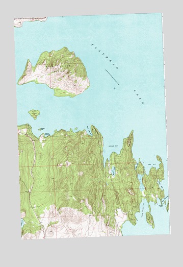
Wild Horse Island, MT USGS Topographic Map
Click on map above to begin viewing in our Map Viewer.

This topographic map contains these locations and features:
Feature Name Type Latitude Longitude GNIS ID View Map
23N20W04BBA_01 WellWellN47.7902°W114.1737°824964View Map
23N20W10DCDC01 WellWellN47.7591°W114.1415°824848View Map
23N20W16BDCA01 WellWellN47.7569°W114.1696°824843View Map
23N20W16CBC_01 WellWellN47.7519°W114.1762°824822View Map
23N21W13BBD_01 WellWellN47.7591°W114.2373°824849View Map
24N19W22CBAA01 WellWellN47.8261°W114.1746°825038View Map
24N21W25DDD_01 WellWellN47.8063°W114.2237°824994View Map
24N21W36AAA_01 WellWellN47.8044°W114.2237°824991View Map
24N21W36DBCA01 WellWellN47.7961°W114.2301°824974View Map
Black PointCapeN47.7933°W114.1326°768976View Map
Cat BayBayN47.7908°W114.1398°769668View Map
Dream IslandIslandN47.8119°W114.2307°770746View Map
Flathead Lake State Park - Wild Horse Island UnitParkN47.8416°W114.2093°1796797View Map
Indian BayBayN47.8022°W114.1707°772679View Map
Jette LakeLakeN47.7596°W114.2496°772817View Map
Kings PointCapeN47.7586°W114.1415°773056View Map
Kings PointPopulated PlaceN47.7683°W114.1515°1853182View Map
Kings Point Census Designated PlaceCensusN47.7584°W114.1410°2408482View Map
Lansing PointCapeN47.7669°W114.1309°773222View Map
Lentz PointCapeN47.8138°W114.2398°773301View Map
LindisfarnePopulated PlaceN47.8088°W114.2285°801067View Map
Lindisfarne Census Designated PlaceCensusN47.8042°W114.2121°2583822View Map
Little Bull (historical)LocaleN47.7638°W114.1273°1796909View Map
Little Bull IslandIslandN47.7680°W114.1251°773421View Map
Matterhorn PointCapeN47.8041°W114.1571°773931View Map
Melita IslandIslandN47.8213°W114.2357°774091View Map
Safety BayBayN47.7777°W114.1321°776073View Map
Stone Quarry BayBayN47.7649°W114.1468°777235View Map
Taylor BayBayN47.7897°W114.1515°777426View Map
White Swan BayBayN47.8097°W114.1918°778404View Map
White Swan PointCapeN47.8099°W114.1860°778405View Map
Wild Horse IslandIslandN47.8452°W114.2151°778471View Map
Wolf PointCapeN47.7563°W114.1551°778651View Map
Wymore LakeLakeN47.7867°W114.1712°778708View Map

Note: Coordinates in the location and feature list above are referenced to NAD83 datum.


Copyright (C) 2008-2024 Ryan Niemi / Sunset Dynamics ... All Rights Reserved