TopoQuest Logo
Do you find TopoQuest useful?
Help keep TopoQuest running and adding new maps/features by donating!
Bitcoin:  19c7KJd3qBynnjoSw5npx9KScwjBe4ifkT
Litecoin:  LXs6TkuXGGXo1vDsWCkWVdjQX94eUKd6ui
Home View Maps Find Maps Find Places Resources & Links


Whitewright, Texas Topographic Map

USGS Map Title: Whitewright, TX
USGS Map MRC: 33096E4
DRG (GeoTIFF) Download: o33096e4.tif


Neighboring USGS Topographic Map Quads:


  Sherman, TX  
33096F5
 

  Ambrose, TX  
33096F4
 

  Mulberry, TX  
33096F3
 

  Howe, TX  
33096E5
 

  Whitewright, TX  
33096E4
 

  Ector, TX  
33096E3
 

  Van Alstyne, TX  
33096D5
 

  Pilot Grove, TX  
33096D4
 

  Trenton, TX  
33096D3


Map MRC Location:

N34°
W97°
N34°
W96°
H8 H7 H6 H5 H4 H3 H2 H1
G8 G7 G6 G5 G4 G3 G2 G1
F8 F7 F6 F5 F4 F3 F2 F1
E8 E7 E6 E5 E4 E3 E2 E1
D8 D7 D6 D5 D4 D3 D2 D1
C8 C7 C6 C5 C4 C3 C2 C1
B8 B7 B6 B5 B4 B3 B2 B1
A8 A7 A6 A5 A4 A3 A2 A1
N33°
W97°
N33°
W96°

Whitewright, TX USGS 1:24K Topographic Map Preview:
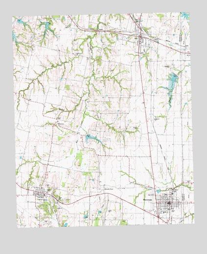
Whitewright, TX USGS Topographic Map
Click on map above to begin viewing in our Map Viewer.

This topographic map contains these locations and features:
Feature Name Type Latitude Longitude GNIS ID View Map
Antioch ChurchChurchN33.6187°W96.4603°1351208View Map
Batsell CemeteryCemeteryN33.5472°W96.4379°2768117View Map
BellsPopulated PlaceN33.6104°W96.4108°1351851View Map
Bells - Savoy Emergency Medical ServicesBuildingN33.6056°W96.3939°2656007View Map
Bells City HallBuildingN33.6081°W96.4093°2754058View Map
Bells Fire DepartmentBuildingN33.6102°W96.4090°2551447View Map
Bells North CemeteryCemeteryN33.6213°W96.4144°1889999View Map
Bells Police DepartmentBuildingN33.6081°W96.4093°2739031View Map
Bells Post OfficePost OfficeN33.6125°W96.4220°2731449View Map
Bethel CemeteryCemeteryN33.6010°W96.4393°1384210View Map
Bethel SchoolSchoolN33.5904°W96.4319°1351962View Map
Brushy CreekStreamN33.6115°W96.4444°1353041View Map
CanaanPopulated PlaceN33.5546°W96.4017°1379498View Map
City of Tom BeanCivilN33.5201°W96.4844°2412079View Map
City of Whitewright Emergency Medical ServicesBuildingN33.5125°W96.3995°2655894View Map
Edwards ChapelChurchN33.5640°W96.4703°1889663View Map
Everheart - Canaan CemeteryCemeteryN33.5575°W96.4139°1357132View Map
Greenwood CemeteryCemeteryN33.5929°W96.3903°1889665View Map
Hestand CreekStreamN33.5787°W96.4478°1359092View Map
IdaPopulated PlaceN33.5751°W96.4900°1379982View Map
Kentucky TownPopulated PlaceN33.5218°W96.4389°1380026View Map
Kentucky Town CemeteryCemeteryN33.5138°W96.4305°2768116View Map
Mag Drop AirportAirportN33.5574°W96.4076°2675787View Map
Montgomery CemeteryCemeteryN33.5629°W96.4023°1363060View Map
Oak Hill CemeteryCemeteryN33.5244°W96.3813°1364287View Map
Pritchard AirportAirportN33.6069°W96.4175°2717035View Map
Rosehill CemeteryCemeteryN33.6098°W96.4017°1889664View Map
Soil Conservation Service Site 1 DamDamN33.5884°W96.3836°1858437View Map
Soil Conservation Service Site 1 ReservoirReservoirN33.5884°W96.3836°1858438View Map
Soil Conservation Service Site 23 DamDamN33.6234°W96.4736°1858315View Map
Soil Conservation Service Site 23 ReservoirReservoirN33.6234°W96.4736°1858316View Map
Soil Conservation Service Site 26 DamDamN33.5401°W96.4786°1863000View Map
Soil Conservation Service Site 26 ReservoirReservoirN33.5401°W96.4786°1863001View Map
Soil Conservation Service Site 27 DamDamN33.5551°W96.4486°1858317View Map
Soil Conservation Service Site 27 ReservoirReservoirN33.5551°W96.4486°1858318View Map
Soil Conservation Service Site 29 DamDamN33.5734°W96.4536°1863144View Map
Soil Conservation Service Site 29 ReservoirReservoirN33.5734°W96.4536°1863145View Map
Soil Conservation Service Site 3 DamDamN33.5001°W96.4653°1858327View Map
Soil Conservation Service Site 3 ReservoirReservoirN33.5001°W96.4653°1858328View Map
Soil Conservation Service Site 4a DamDamN33.5084°W96.4419°1858329View Map
Soil Conservation Service Site 4a ReservoirReservoirN33.5084°W96.4419°1858330View Map
Soil Conservation Service Site 4b DamDamN33.5051°W96.4519°1858331View Map
Soil Conservation Service Site 4b ReservoirReservoirN33.5051°W96.4519°1858332View Map
Tom BeanPopulated PlaceN33.5201°W96.4839°1369993View Map
Tom Bean City HallBuildingN33.5193°W96.4846°2753965View Map
Tom Bean Police DepartmentBuildingN33.5193°W96.4846°2739060View Map
Tom Bean Post OfficePost OfficeN33.5203°W96.4843°2731983View Map
Tom Bean Volunteer Fire DepartmentBuildingN33.5206°W96.4851°2551514View Map
Town of BellsCivilN33.6166°W96.4127°2411675View Map
Town of WhitewrightCivilN33.5109°W96.3956°2413481View Map
Trail LakeReservoirN33.6218°W96.4986°1865085View Map
Trail Lake DamDamN33.6218°W96.4986°1865084View Map
Vittitoe CemeteryCemeteryN33.5087°W96.4364°1370672View Map
Washburn CemeteryCemeteryN33.6018°W96.4558°1370873View Map
WhiterockPopulated PlaceN33.5621°W96.4711°1380774View Map
WhitewrightPopulated PlaceN33.5129°W96.3925°1371463View Map
Whitewright City CemeteryCemeteryN33.5116°W96.3848°2768118View Map
Whitewright City HallBuildingN33.5129°W96.3945°2754004View Map
Whitewright Elementary SchoolSchoolN33.5074°W96.3956°2005533View Map
Whitewright Fire DepartmentBuildingN33.5132°W96.3943°2551531View Map
Whitewright High SchoolSchoolN33.5046°W96.3957°2005534View Map
Whitewright Middle SchoolSchoolN33.5074°W96.3970°2005535View Map
Whitewright Police DepartmentBuildingN33.5125°W96.3994°2738900View Map
Whitewright Post OfficePost OfficeN33.5135°W96.3938°2732042View Map
Windwood Farm AirportAirportN33.5694°W96.3977°2675850View Map

Note: Coordinates in the location and feature list above are referenced to NAD83 datum.


Copyright (C) 2008-2024 Ryan Niemi / Sunset Dynamics ... All Rights Reserved