TopoQuest Logo
Do you find TopoQuest useful?
Help keep TopoQuest running and adding new maps/features by donating!
Bitcoin:  19c7KJd3qBynnjoSw5npx9KScwjBe4ifkT
Litecoin:  LXs6TkuXGGXo1vDsWCkWVdjQX94eUKd6ui
Home View Maps Find Maps Find Places Resources & Links


White Plains, Georgia Topographic Map

USGS Map Title: White Plains, GA
USGS Map MRC: 33083D1
DRG (GeoTIFF) Download: o33083d1.tif


Neighboring USGS Topographic Map Quads:


  Greensboro, GA  
33083E2
 

  Union Point, GA  
33083E1
 

  Crawfordville, GA  
33082E8
 

  Liberty, GA  
33083D2
 

  White Plains, GA  
33083D1
 

  Sparta NW, GA  
33082D8
 

  Rockville, GA  
33083C2
 

  Shoulderbone, GA  
33083C1
 

  Sparta, GA  
33082C8


Map MRC Location:

N34°
W84°
N34°
W83°
H8 H7 H6 H5 H4 H3 H2 H1
G8 G7 G6 G5 G4 G3 G2 G1
F8 F7 F6 F5 F4 F3 F2 F1
E8 E7 E6 E5 E4 E3 E2 E1
D8 D7 D6 D5 D4 D3 D2 D1
C8 C7 C6 C5 C4 C3 C2 C1
B8 B7 B6 B5 B4 B3 B2 B1
A8 A7 A6 A5 A4 A3 A2 A1
N33°
W84°
N33°
W83°

White Plains, GA USGS 1:24K Topographic Map Preview:
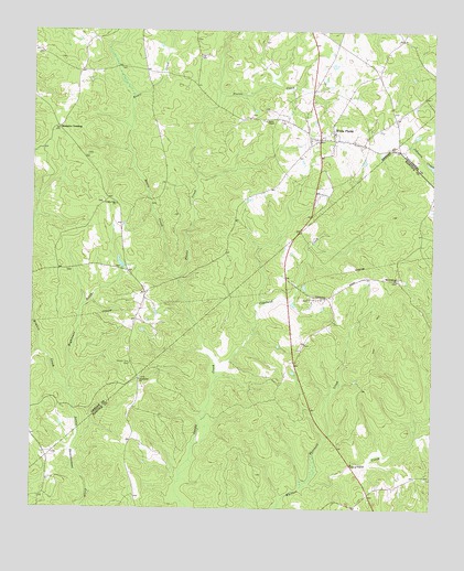
White Plains, GA USGS Topographic Map
Click on map above to begin viewing in our Map Viewer.

This topographic map contains these locations and features:
Feature Name Type Latitude Longitude GNIS ID View Map
Barnhart-Owens CemeteryCemeteryN33.3896°W83.1182°1705449View Map
Baugh Family CemeteryCemeteryN33.3757°W83.1221°1985774View Map
Big House FieldAreaN33.4360°W83.0207°348193View Map
Bruce CemeteryCemeteryN33.4546°W83.0865°1705391View Map
Bruce CreekStreamN33.4354°W83.0793°311905View Map
Centennial CemeteryCemeteryN33.4090°W83.0907°1705450View Map
Centennial ChurchChurchN33.4087°W83.0910°355073View Map
Chapman CemeteryCemeteryN33.4379°W83.0990°1705395View Map
Chapman CemeteryCemeteryN33.4371°W83.1140°1705396View Map
City of White PlainsCivilN33.4806°W83.0372°2405734View Map
Clark-Webb-Simmons Family CemeteryCemeteryN33.3837°W83.0018°1985786View Map
Copeland CreekStreamN33.4107°W83.0668°312964View Map
Copelans Store (historical)LocaleN33.4315°W83.0902°348658View Map
Copelin Family CemeteryCemeteryN33.4301°W83.0385°1985879View Map
County Line CemeteryCemeteryN33.4129°W83.0938°313026View Map
County Line ChurchChurchN33.4549°W83.0988°313035View Map
County Line Church (historical)ChurchN33.4129°W83.0940°348659View Map
Fuller School (historical)SchoolN33.4893°W83.0902°348670View Map
Gum HillPopulated PlaceN33.4304°W83.0332°348208View Map
Hightower CreekStreamN33.4049°W83.1129°315401View Map
Jackson CemeteryCemeteryN33.4679°W83.1079°1705411View Map
Kimbro CreekStreamN33.4049°W83.1129°316418View Map
Lewis CemeteryCemeteryN33.4979°W83.0746°348686View Map
Moons Academy (historical)SchoolN33.4543°W83.0988°348693View Map
Moons Academy CemeteryCemeteryN33.4551°W83.1032°1705422View Map
Mosquito CrossingPopulated PlaceN33.4746°W83.1171°332425View Map
Mount Gilead Church (historical)ChurchN33.3960°W83.0929°348230View Map
Mount Stephens CemeteryCemeteryN33.4346°W83.0110°348232View Map
Mount Stephens ChurchChurchN33.4349°W83.0110°318885View Map
Mount Stephens School (historical)SchoolN33.4354°W83.0110°348233View Map
Pierce ChapelChurchN33.4768°W83.0527°320494View Map
Pierce CreekStreamN33.4354°W83.0793°320499View Map
Plunkett CreekStreamN33.3812°W83.0402°320954View Map
Rowland CemeteryCemeteryN33.4929°W83.1168°1705432View Map
Second Baptist ChurchChurchN33.4735°W83.0310°348718View Map
Smiths School (historical)SchoolN33.4393°W83.0702°348720View Map
Swaggy ValleyPopulated PlaceN33.4557°W83.0371°348723View Map
The Blue HoleReservoirN33.4660°W83.0216°348650View Map
Thompson CemeteryCemeteryN33.4360°W83.1246°348725View Map
White PlainsPopulated PlaceN33.4721°W83.0354°356635View Map
White Plains Baptist ChurchChurchN33.4726°W83.0346°348734View Map
White Plains CemeteryCemeteryN33.4726°W83.0340°348735View Map
White Plains DivisionCivilN33.4520°W83.1036°1936646View Map
White Plains Methodist ChurchChurchN33.4715°W83.0382°348737View Map
White Plains Post OfficePost OfficeN33.4724°W83.0365°1705445View Map
White Plains School (historical)SchoolN33.4737°W83.0352°348738View Map
White Plains Volunteer Fire DepartmentBuildingN33.4714°W83.0353°2604224View Map
Wright CemeteryCemeteryN33.4785°W83.0571°1705447View Map

Note: Coordinates in the location and feature list above are referenced to NAD83 datum.


Copyright (C) 2008-2024 Ryan Niemi / Sunset Dynamics ... All Rights Reserved