TopoQuest Logo
Do you find TopoQuest useful?
Help keep TopoQuest running and adding new maps/features by donating!
Bitcoin:  19c7KJd3qBynnjoSw5npx9KScwjBe4ifkT
Litecoin:  LXs6TkuXGGXo1vDsWCkWVdjQX94eUKd6ui
Home View Maps Find Maps Find Places Resources & Links


White Lake, North Carolina Topographic Map

USGS Map Title: White Lake, NC
USGS Map MRC: 34078F4
DRG (GeoTIFF) Download: o34078f4.tif


Neighboring USGS Topographic Map Quads:


  Ammon, NC  
34078G5
 

  Garland, NC  
34078G4
 

  Ingold, NC  
34078G3
 

  Elizabethtown North, NC  
34078F5
 

  White Lake, NC  
34078F4
 

  Tomahawk, NC  
34078F3
 

  Elizabethtown South, NC  
34078E5
 

  Singletary Lake, NC  
34078E4
 

  Rowan, NC  
34078E3


Map MRC Location:

N35°
W79°
N35°
W78°
H8 H7 H6 H5 H4 H3 H2 H1
G8 G7 G6 G5 G4 G3 G2 G1
F8 F7 F6 F5 F4 F3 F2 F1
E8 E7 E6 E5 E4 E3 E2 E1
D8 D7 D6 D5 D4 D3 D2 D1
C8 C7 C6 C5 C4 C3 C2 C1
B8 B7 B6 B5 B4 B3 B2 B1
A8 A7 A6 A5 A4 A3 A2 A1
N34°
W79°
N34°
W78°

White Lake, NC USGS 1:24K Topographic Map Preview:
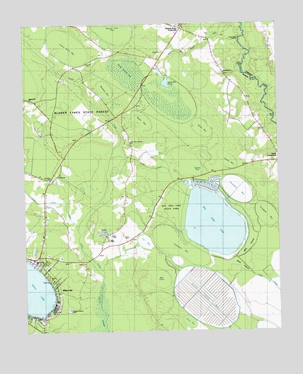
White Lake, NC USGS Topographic Map
Click on map above to begin viewing in our Map Viewer.

This topographic map contains these locations and features:
Feature Name Type Latitude Longitude GNIS ID View Map
Bay Tree LakeLakeN34.6687°W78.4071°981534View Map
Bay Tree Lake State ParkParkN34.6754°W78.4272°1026234View Map
Bay Tree Lakes Volunteer Fire DepartmentBuildingN34.6879°W78.4160°2638862View Map
Beard ChapelChurchN34.7166°W78.4453°980743View Map
Beaver Dam BaySwampN34.7479°W78.4578°980804View Map
Big BaySwampN34.6357°W78.4522°981309View Map
Black Creek BaySwampN34.6421°W78.4139°981524View Map
Boat IslandIslandN34.6518°W78.3892°1025172View Map
Boone Field LandingLocaleN34.7443°W78.3939°1019255View Map
Butler BaySwampN34.7074°W78.4106°982330View Map
Carroll CemeteryCemeteryN34.6549°W78.4925°982684View Map
Causeway BaySwampN34.6624°W78.4292°982780View Map
Chinquapin BaySwampN34.6927°W78.4703°983149View Map
Church BaySwampN34.6963°W78.4889°983187View Map
Church LandingLocaleN34.7329°W78.3936°1019676View Map
Colly ChapelChurchN34.6624°W78.4592°983394View Map
Cooley BaySwampN34.6954°W78.3994°983493View Map
Cotton Patch BaySwampN34.7427°W78.4775°983596View Map
Cowpen BaySwampN34.7241°W78.4856°983655View Map
Cromartie MarshSwampN34.7485°W78.3881°983759View Map
Dyson CemeteryCemeteryN34.6538°W78.4706°984465View Map
Entry BaySwampN34.6285°W78.4183°984817View Map
Floodgate BayBasinN34.6707°W78.3833°1025320View Map
Hickory Grove CrossroadsPopulated PlaceN34.7485°W78.4225°1025384View Map
Hickory Grove Volunteer Fire DepartmentBuildingN34.7493°W78.4236°2638670View Map
Horsepen BaySwampN34.6843°W78.3947°987124View Map
Jumping Run CreekStreamN34.7499°W78.3906°1025439View Map
Lake DrainGutN34.6918°W78.4372°1026233View Map
Little Colly CreekStreamN34.6682°W78.4745°988576View Map
Maple BaySwampN34.7127°W78.4417°989295View Map
Marshall BaySwampN34.7249°W78.4603°989377View Map
Marshburn CemeteriesCemeteryN34.6863°W78.4883°989385View Map
Melvin CemeteryCemeteryN34.6299°W78.4900°989719View Map
Mill IslandIslandN34.6624°W78.3878°1025536View Map
Mill PondSwampN34.6485°W78.4344°989977View Map
Norris CemeteryCemeteryN34.6638°W78.4514°991189View Map
Pleasant Hill ChurchChurchN34.7202°W78.4970°992515View Map
Pocosin BaySwampN34.6718°W78.4586°992604View Map
Reedy Branch BaySwampN34.7305°W78.4482°1022211View Map
Saint Peters ChurchChurchN34.6882°W78.4847°1025670View Map
Sand Hill CemeteryCemeteryN34.7346°W78.4675°994221View Map
Smith Memorial Gardens CemeteryCemeteryN34.7016°W78.4489°1025709View Map
Smith Mill PondReservoirN34.7261°W78.4294°1025710View Map
Smith Mill Pond RunStreamN34.7282°W78.4289°1025711View Map
South River ChurchChurchN34.7304°W78.4017°995205View Map
Spring BayBasinN34.6916°W78.4136°1025724View Map
Till BaySwampN34.6629°W78.4406°996103View Map
Town of White LakeCivilN34.6421°W78.4970°2406878View Map
Township of CollyCivilN34.6610°W78.4964°1026427View Map
White LakePopulated PlaceN34.6404°W78.4839°1023198View Map
White LakeLakeN34.6429°W78.4981°997140View Map
White Lake Airport (historical)AirportN34.6585°W78.4970°997855View Map
White Lake ChurchChurchN34.6563°W78.4883°997141View Map
White Lake Fire DepartmentBuildingN34.6332°W78.4857°2638954View Map
White Lake Police DepartmentBuildingN34.6329°W78.4861°2130998View Map
White Lake Post Office (historical)Post OfficeN34.6404°W78.4839°1940258View Map

Note: Coordinates in the location and feature list above are referenced to NAD83 datum.


Copyright (C) 2008-2024 Ryan Niemi / Sunset Dynamics ... All Rights Reserved