TopoQuest Logo
Do you find TopoQuest useful?
Help keep TopoQuest running and adding new maps/features by donating!
Bitcoin:  19c7KJd3qBynnjoSw5npx9KScwjBe4ifkT
Litecoin:  LXs6TkuXGGXo1vDsWCkWVdjQX94eUKd6ui
Home View Maps Find Maps Find Places Resources & Links


Wheeler Peak, Nevada Topographic Map

USGS Map Title: Wheeler Peak, NV
USGS Map MRC: 38114H3
DRG (GeoTIFF) Download: o38114h3.tif


Neighboring USGS Topographic Map Quads:


  Hogum, NV  
39114A4
 

  Windy Peak, NV  
39114A3
 

  Lehman Caves, NV  
39114A2
 

  Baking Powder Flat, NV  
38114H4
 

  Wheeler Peak, NV  
38114H3
 

  Kious Spring, NV  
38114H2
 

  Minerva, NV  
38114G4
 

  Minerva Canyon, NV  
38114G3
 

  Arch Canyon, NV  
38114G2


Map MRC Location:

N39°
W115°
N39°
W114°
H8 H7 H6 H5 H4 H3 H2 H1
G8 G7 G6 G5 G4 G3 G2 G1
F8 F7 F6 F5 F4 F3 F2 F1
E8 E7 E6 E5 E4 E3 E2 E1
D8 D7 D6 D5 D4 D3 D2 D1
C8 C7 C6 C5 C4 C3 C2 C1
B8 B7 B6 B5 B4 B3 B2 B1
A8 A7 A6 A5 A4 A3 A2 A1
N38°
W115°
N38°
W114°

Wheeler Peak, NV USGS 1:24K Topographic Map Preview:
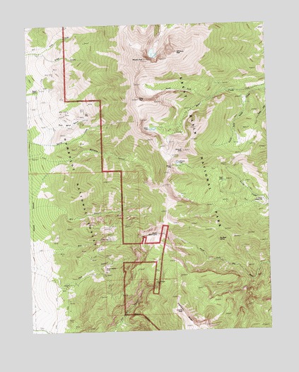
Wheeler Peak, NV USGS Topographic Map
Click on map above to begin viewing in our Map Viewer.

This topographic map contains these locations and features:
Feature Name Type Latitude Longitude GNIS ID View Map
Baker LakeLakeN38.9573°W114.3104°858788View Map
Baker PeakSummitN38.9697°W114.3173°858789View Map
Baker Shoshone TrailTrailN38.9113°W114.2753°858790View Map
Big Wash SpringSpringN38.9118°W114.2771°862415View Map
Box CanyonValleyN38.9051°W114.3664°858989View Map
Bristlecone Pine Interpretive TrailTrailN38.9947°W114.3061°863032View Map
Dead LakeLakeN38.9359°W114.2740°859468View Map
Dry CanyonValleyN38.9265°W114.3622°859558View Map
Great Basin National ParkParkN38.9461°W114.2580°862430View Map
Highland RidgeRidgeN38.8765°W114.2920°859993View Map
Hub MineMineN38.9622°W114.3500°860064View Map
Hub Mine BasinBasinN38.9602°W114.3553°860065View Map
Jeff Davis PeakSummitN38.9886°W114.2970°862412View Map
Johnson LakeLakeN38.9436°W114.2977°860224View Map
Johnson MineMineN38.9419°W114.3011°862413View Map
Lincoln PeakSummitN38.8828°W114.2971°860345View Map
Mount WashingtonSummitN38.9144°W114.3092°861902View Map
Mount Washington Mining DistrictCivilN38.8944°W114.3475°858465View Map
Mount Wheeler MineMineN38.8991°W114.3364°863799View Map
North Fork Baker CreekStreamN38.9691°W114.2808°860751View Map
Pine CreekStreamN38.9891°W114.3678°860951View Map
Pole CanyonValleyN38.8982°W114.3646°860991View Map
Pyramid PeakSummitN38.9484°W114.2952°861033View Map
Raised SpringSpringN38.9731°W114.3701°861055View Map
Saint Lawrence MineMineN38.8986°W114.3092°861235View Map
Shoshone CampgroundLocaleN38.9280°W114.2533°862414View Map
Treasure LakeLakeN38.9578°W114.3055°862915View Map
Tungsten Mines Post Office (historical)Post OfficeN38.9622°W114.3511°864891View Map
Tungsten Mining DistrictCivilN38.9813°W114.3569°853528View Map
Wheeler PeakSummitN38.9858°W114.3140°861956View Map
Wheeler Peak Scenic Area (historical)AreaN38.9411°W114.2753°862503View Map
Williams CanyonValleyN38.9440°W114.3605°862021View Map

Note: Coordinates in the location and feature list above are referenced to NAD83 datum.


Copyright (C) 2008-2024 Ryan Niemi / Sunset Dynamics ... All Rights Reserved