TopoQuest Logo
Do you find TopoQuest useful?
Help keep TopoQuest running and adding new maps/features by donating!
Bitcoin:  19c7KJd3qBynnjoSw5npx9KScwjBe4ifkT
Litecoin:  LXs6TkuXGGXo1vDsWCkWVdjQX94eUKd6ui
Home View Maps Find Maps Find Places Resources & Links


West Shokan, New York Topographic Map

USGS Map Title: West Shokan, NY
USGS Map MRC: 41074H3
DRG (GeoTIFF) Download: o41074h3.tif


Neighboring USGS Topographic Map Quads:


  Shandaken, NY  
42074A4
 

  Phoenicia, NY  
42074A3
 

  Bearsville, NY  
42074A2
 

  Peekamoose Mountain, NY  
41074H4
 

  West Shokan, NY  
41074H3
 

  Ashokan, NY  
41074H2
 

  Rondout Reservoir, NY  
41074G4
 

  Kerhonkson, NY  
41074G3
 

  Mohonk Lake, NY  
41074G2


Map MRC Location:

N42°
W75°
N42°
W74°
H8 H7 H6 H5 H4 H3 H2 H1
G8 G7 G6 G5 G4 G3 G2 G1
F8 F7 F6 F5 F4 F3 F2 F1
E8 E7 E6 E5 E4 E3 E2 E1
D8 D7 D6 D5 D4 D3 D2 D1
C8 C7 C6 C5 C4 C3 C2 C1
B8 B7 B6 B5 B4 B3 B2 B1
A8 A7 A6 A5 A4 A3 A2 A1
N41°
W75°
N41°
W74°

West Shokan, NY USGS 1:24K Topographic Map Preview:
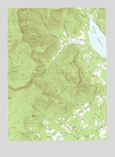
West Shokan, NY USGS Topographic Map
Click on map above to begin viewing in our Map Viewer.

This topographic map contains these locations and features:
Feature Name Type Latitude Longitude GNIS ID View Map
Balsam CapSummitN41.9770°W74.3574°942944View Map
Beaver LakeLakeN41.8888°W74.2578°943392View Map
Big Rosy Bone KnobSummitN41.8984°W74.3449°943947View Map
Breath HillSummitN41.9365°W74.3552°944675View Map
BrodheadPopulated PlaceN41.9437°W74.2574°944810View Map
Brodhead School (historical)SchoolN41.9433°W74.2550°2371412View Map
Bush KillStreamN41.9268°W74.3385°945311View Map
Bushkill School (historical)SchoolN41.9711°W74.2981°2371413View Map
Dry BrookStreamN41.9712°W74.2763°948665View Map
Father Divine Lodge (historical)BuildingN41.8933°W74.3272°2371410View Map
Flat HillSummitN41.8770°W74.3577°950241View Map
Friday MountainSummitN41.9876°W74.3621°950728View Map
Hanover MountainSummitN41.9612°W74.3296°952176View Map
High PointSummitN41.9248°W74.2879°952753View Map
Kanape BrookStreamN41.9356°W74.3274°954376View Map
Kanape Jeep TrailTrailN41.9223°W74.3099°954377View Map
Little RockySummitN41.9187°W74.3321°955665View Map
Maltby Hollow BrookStreamN41.9662°W74.2949°956327View Map
Mine HollowValleyN41.9498°W74.3210°957382View Map
Mombaccus MountainSummitN41.9098°W74.3113°957499View Map
Moonhaw Gun ClubLocaleN41.9861°W74.3289°2371411View Map
Olive Free LibraryBuildingN41.9638°W74.2753°2599428View Map
Olive Volunteer Fire Department 1 Samsonville Company 4BuildingN41.8936°W74.2688°2735508View Map
Olive Volunteer Fire Department 1 West Shokan Company 3BuildingN41.9683°W74.2810°2735510View Map
PalentownPopulated PlaceN41.8790°W74.3215°972909View Map
Palentown CemeteryCemeteryN41.8790°W74.3098°959771View Map
Picket BrookStreamN41.9434°W74.3665°960332View Map
Pople HillSummitN41.8862°W74.3663°960948View Map
Rochester School (historical)SchoolN41.8778°W74.3228°2371414View Map
Rocky MountainSummitN41.9729°W74.3727°962784View Map
SamsonvillePopulated PlaceN41.8876°W74.2940°964351View Map
Samsonville School (historical)SchoolN41.8900°W74.2919°2371415View Map
Samuels PointCliffN41.9962°W74.3082°964356View Map
South Hollow BrookStreamN41.9504°W74.3185°965785View Map
South MountainSummitN41.9493°W74.2932°965816View Map
Spencers LedgeCliffN41.9154°W74.3732°965989View Map
Steiny HillSummitN41.8773°W74.3388°966343View Map
Town of OliveCivilN41.9470°W74.2631°979307View Map
Traver HollowValleyN41.9915°W74.2721°967764View Map
Ulster CountyCivilN41.8881°W74.2586°974153View Map
Vernooy Falls TrailTrailN41.8781°W74.3649°968501View Map
Watson HollowValleyN41.9659°W74.2996°968927View Map
West ShokanPopulated PlaceN41.9673°W74.2871°970867View Map
West Shokan School (historical)SchoolN41.9642°W74.2756°2371416View Map
WinchellPopulated PlaceN41.9159°W74.2554°973275View Map
Winchell School (historical)SchoolN41.9142°W74.2564°2371417View Map
Wittenberg BrookStreamN41.9768°W74.3213°971527View Map

Note: Coordinates in the location and feature list above are referenced to NAD83 datum.


Copyright (C) 2008-2024 Ryan Niemi / Sunset Dynamics ... All Rights Reserved