TopoQuest Logo
Do you find TopoQuest useful?
Help keep TopoQuest running and adding new maps/features by donating!
Bitcoin:  19c7KJd3qBynnjoSw5npx9KScwjBe4ifkT
Litecoin:  LXs6TkuXGGXo1vDsWCkWVdjQX94eUKd6ui
Home View Maps Find Maps Find Places Resources & Links


Weatherly, Pennsylvania Topographic Map

USGS Map Title: Weatherly, PA
USGS Map MRC: 40075H7
DRG (GeoTIFF) Download: o40075h7.tif


Neighboring USGS Topographic Map Quads:


  Freeland, PA  
41075A8
 

  White Haven, PA  
41075A7
 

  Hickory Run, PA  
41075A6
 

  Hazleton, PA  
40075H8
 

  Weatherly, PA  
40075H7
 

  Christmans, PA  
40075H6
 

  Tamaqua, PA  
40075G8
 

  Nesquehoning, PA  
40075G7
 

  Lehighton, PA  
40075G6


Map MRC Location:

N41°
W76°
N41°
W75°
H8 H7 H6 H5 H4 H3 H2 H1
G8 G7 G6 G5 G4 G3 G2 G1
F8 F7 F6 F5 F4 F3 F2 F1
E8 E7 E6 E5 E4 E3 E2 E1
D8 D7 D6 D5 D4 D3 D2 D1
C8 C7 C6 C5 C4 C3 C2 C1
B8 B7 B6 B5 B4 B3 B2 B1
A8 A7 A6 A5 A4 A3 A2 A1
N40°
W76°
N40°
W75°

Weatherly, PA USGS 1:24K Topographic Map Preview:
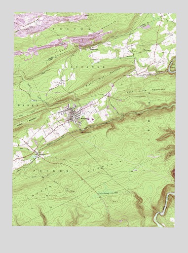
Weatherly, PA USGS Topographic Map
Click on map above to begin viewing in our Map Viewer.

This topographic map contains these locations and features:
Feature Name Type Latitude Longitude GNIS ID View Map
Beaver CreekStreamN40.9459°W75.8469°1169006View Map
Beisel Run DamDamN40.9145°W75.8505°1208738View Map
Black Creek JunctionPopulated PlaceN40.9318°W75.8224°1203110View Map
Borough of WeatherlyCivilN40.9420°W75.8209°1215052View Map
Broad MountainSummitN40.9098°W75.8066°1212038View Map
Broad Mountain TowerTowerN40.8954°W75.8288°1212363View Map
Brushy HollowValleyN40.9409°W75.7900°1170474View Map
Brushy Hollow RunStreamN40.9406°W75.7896°1212365View Map
Buck MountainPopulated PlaceN40.9801°W75.8130°1170520View Map
Buck Mountain CollieryBuildingN40.9998°W75.8374°1207135View Map
Buck Mountain Colliery (historical)BuildingN40.9790°W75.8238°1207664View Map
Buck Mountain CreekStreamN40.9670°W75.7549°1192207View Map
Buckley Colliery StationLocaleN40.9898°W75.8638°1212519View Map
Citizens Fire Company District 20BuildingN40.9446°W75.8274°2653455View Map
EckleyPopulated PlaceN40.9934°W75.8624°1173975View Map
Eckley StationLocaleN40.9893°W75.8671°1212518View Map
Eurana Park PoolReservoirN40.9399°W75.8210°1212362View Map
Glen OnokoValleyN40.8843°W75.7619°1201480View Map
Glen Onoko StationLocaleN40.8859°W75.7574°1212366View Map
Greater Weatherly AmbulanceBuildingN40.9376°W75.8268°2722176View Map
Grover AirportAirportN40.9097°W75.8698°2442993View Map
Hazle CreekStreamN40.9459°W75.8469°1192595View Map
Hazle Creek BridgeBridgeN40.9473°W75.8499°1207136View Map
Hazle Creek Junction StationLocaleN40.9473°W75.8496°1212360View Map
HudsondalePopulated PlaceN40.9168°W75.8552°1177552View Map
Hughes SwampSwampN40.8954°W75.8050°1177568View Map
Indian RunStreamN40.9651°W75.7638°1177776View Map
Indian Run DamDamN40.9634°W75.7746°1208727View Map
Koons CreekStreamN40.9440°W75.8296°1212361View Map
Larrytown SchoolSchoolN40.9876°W75.7521°1178899View Map
Lehigh and Lausanne Rural Volunteer Fire Company District 19BuildingN40.9766°W75.7665°2652992View Map
Nesquehoning CreekStreamN40.8751°W75.7621°1182269View Map
Oberson RunStreamN40.9109°W75.8652°1182860View Map
Penn Haven MountainSummitN40.9554°W75.7585°1183476View Map
Quakake CreekStreamN40.9320°W75.8219°1184517View Map
Quakake DamDamN40.9151°W75.8596°1195141View Map
Quakake LakeReservoirN40.9158°W75.8583°1195140View Map
RockportPopulated PlaceN40.9651°W75.7632°1185319View Map
Round Head MountainSummitN40.9609°W75.8088°1185516View Map
Saint Joseph ChurchChurchN40.9784°W75.7732°1186195View Map
Schaffers RunStreamN40.9734°W75.7932°1212364View Map
Township of LausanneCivilN40.9682°W75.8211°1216111View Map
Township of LehighCivilN40.9457°W75.7663°1216112View Map
Upper Buck Mountain DamDamN40.9715°W75.8083°1208730View Map
Valley Hospital Medevac Station 4BuildingN40.9879°W75.7599°2722275View Map
WeatherlyPopulated PlaceN40.9418°W75.8296°1193723View Map
WeatherlyPopulated PlaceN40.9418°W75.8283°1190732View Map
Weatherly Police DepartmentBuildingN40.9413°W75.8292°2780173View Map
Weatherly Post OfficePost OfficeN40.9419°W75.8284°2773024View Map
Wetzel CreekStreamN40.9198°W75.8558°1191195View Map

Note: Coordinates in the location and feature list above are referenced to NAD83 datum.


Copyright (C) 2008-2024 Ryan Niemi / Sunset Dynamics ... All Rights Reserved