TopoQuest Logo
Do you find TopoQuest useful?
Help keep TopoQuest running and adding new maps/features by donating!
Bitcoin:  19c7KJd3qBynnjoSw5npx9KScwjBe4ifkT
Litecoin:  LXs6TkuXGGXo1vDsWCkWVdjQX94eUKd6ui
Home View Maps Find Maps Find Places Resources & Links


Waynesville, North Carolina Topographic Map

USGS Map Title: Waynesville, NC
USGS Map MRC: 35082D8
DRG (GeoTIFF) Download: o35082d8.tif


Neighboring USGS Topographic Map Quads:


  Dellwood, NC  
35083E1
 

  Clyde, NC  
35082E8
 

  Canton, NC  
35082E7
 

  Hazelwood, NC  
35083D1
 

  Waynesville, NC  
35082D8
 

  Cruso, NC  
35082D7
 

  Tuckasegee, NC  
35083C1
 

  Sam Knob, NC  
35082C8
 

  Shining Rock, NC  
35082C7


Map MRC Location:

N36°
W83°
N36°
W82°
H8 H7 H6 H5 H4 H3 H2 H1
G8 G7 G6 G5 G4 G3 G2 G1
F8 F7 F6 F5 F4 F3 F2 F1
E8 E7 E6 E5 E4 E3 E2 E1
D8 D7 D6 D5 D4 D3 D2 D1
C8 C7 C6 C5 C4 C3 C2 C1
B8 B7 B6 B5 B4 B3 B2 B1
A8 A7 A6 A5 A4 A3 A2 A1
N35°
W83°
N35°
W82°

Waynesville, NC USGS 1:24K Topographic Map Preview:
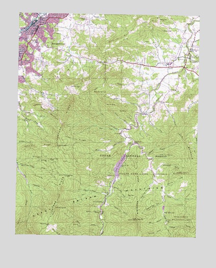
Waynesville, NC USGS Topographic Map
Click on map above to begin viewing in our Map Viewer.

This topographic map contains these locations and features:
Feature Name Type Latitude Longitude GNIS ID View Map
Beaty Spring KnobSummitN35.4565°W82.9485°1019022View Map
BethelPopulated PlaceN35.4734°W82.8960°1019108View Map
Bethel Elementary SchoolSchoolN35.4726°W82.8962°1017576View Map
Bethel High School (historical)SchoolN35.4726°W82.8962°1960035View Map
Big BranchStreamN35.3857°W82.8954°1009260View Map
Big CreekStreamN35.3976°W82.9376°1009301View Map
Big Ridge MineMineN35.4168°W82.9776°1009372View Map
Bird CreekStreamN35.4751°W82.8843°1009419View Map
Burnett SidingPopulated PlaceN35.3959°W82.9385°1019422View Map
Burnetts Siding Baptist ChurchChurchN35.3940°W82.9390°1960037View Map
Camp Daniel Boone DamDamN35.3934°W82.8965°1017185View Map
Camp Daniel Boone LakeReservoirN35.3934°W82.8965°1017186View Map
Cathey CoveValleyN35.3807°W82.8961°1010100View Map
Cathey GapGapN35.4982°W82.9032°1010102View Map
Cecil (historical)Populated PlaceN35.4054°W82.9015°1960038View Map
Cecil SchoolSchoolN35.4326°W82.9282°1010112View Map
Central Elementary SchoolSchoolN35.4968°W82.9754°1017691View Map
Chambers CoveValleyN35.4435°W82.9089°1010159View Map
Cherry Cove CreekStreamN35.4115°W82.9982°1010209View Map
Chestnut Flat CoveValleyN35.3948°W82.8978°1010242View Map
Cold Spring KnobSummitN35.3904°W82.9729°1019726View Map
Coldspring BranchStreamN35.4023°W82.9907°1010395View Map
Curtis CoveValleyN35.3965°W82.9367°1010618View Map
Daniel Boone CampLocaleN35.3884°W82.8971°1010644View Map
Deep CreekStreamN35.4143°W82.9990°1010725View Map
Deep GapGapN35.3982°W82.9174°1010743View Map
Deep GapGapN35.4087°W82.9654°1010745View Map
Deep Gap CoveValleyN35.4045°W82.9062°1010759View Map
Deep Gap CreekStreamN35.4143°W82.9993°1018049View Map
Double Spring GapGapN35.3812°W82.9765°1010884View Map
East Fork Pigeon RiverStreamN35.4790°W82.8821°1010993View Map
Edward CoveValleyN35.4620°W82.9129°1011026View Map
Elizabeth ChapelChurchN35.4973°W82.9543°1011047View Map
Fork MountainSummitN35.3845°W82.9160°1020320View Map
Francis CoveValleyN35.4807°W82.9647°1011369View Map
Francis Cove ChurchChurchN35.4757°W82.9637°1011370View Map
Garner CoveValleyN35.4834°W82.9627°1011439View Map
Green Hill CemeteryCemeteryN35.4837°W82.9907°1011700View Map
Haywood County FarmLocaleN35.4812°W82.8799°1018048View Map
Haywood County Rescue SquadBuildingN35.4934°W82.9881°2720675View Map
Hazelwood Elementary SchoolSchoolN35.4757°W82.9993°1017578View Map
Hickory Flat CoveValleyN35.4023°W82.9323°1012005View Map
High TopSummitN35.3845°W82.9160°1012053View Map
Ike CoveValleyN35.4195°W82.9059°1012325View Map
Inman BranchStreamN35.4443°W82.9143°1012362View Map
Inman ChurchChurchN35.4270°W82.9229°1012363View Map
Lake LoganReservoirN35.4234°W82.9249°998956View Map
Lake LoganLakeN35.4151°W82.9286°1013082View Map
Lake Logan Cecil Volunteer Fire DepartmentBuildingN35.4302°W82.9207°2639095View Map
Lake Logan DamDamN35.4234°W82.9249°1017199View Map
Laurel BranchStreamN35.3876°W82.9407°1012700View Map
Laurel Grove ChurchChurchN35.4109°W82.9032°1012742View Map
Lavinia (historical)Populated PlaceN35.4320°W82.9251°1960041View Map
Lickstone BaldSummitN35.4257°W82.9718°1012866View Map
Lickstone RidgeRidgeN35.4309°W82.9701°1012867View Map
Little East Fork Pigeon RiverStreamN35.4279°W82.9182°1012956View Map
Marg MountainSummitN35.4484°W82.9874°1013323View Map
McClure CreekStreamN35.4304°W82.9249°1013405View Map
Medford BranchStreamN35.4448°W82.9965°1013461View Map
Murray CoveValleyN35.4030°W82.8982°1013856View Map
Nick CreekStreamN35.4354°W82.9307°1013960View Map
Panther BranchStreamN35.4212°W82.9107°1014203View Map
Peter CoveValleyN35.4836°W82.9040°1014348View Map
Peter Cove BranchStreamN35.4698°W82.8976°1014349View Map
Pigeon GapGapN35.4729°W82.9399°1014388View Map
Poplar BranchStreamN35.4382°W82.9215°1014574View Map
Queen CreekStreamN35.3795°W82.9393°1014684View Map
Ratcliff Cove Baptist ChurchChurchN35.4987°W82.9490°1014740View Map
Ratcliff MountainSummitN35.4865°W82.9276°1014741View Map
Ratcliffe CoveValleyN35.4919°W82.9420°1014742View Map
RetreatPopulated PlaceN35.4507°W82.9090°1022226View Map
Riverside Baptist ChurchChurchN35.4445°W82.9121°1014923View Map
Roberson RidgeRidgeN35.4243°W82.9868°1014955View Map
Rocky BranchStreamN35.4520°W82.9024°1015022View Map
Rocky KnobSummitN35.4918°W82.9015°1022353View Map
Round KnobSummitN35.4487°W82.9387°1022410View Map
Sam BranchStreamN35.4348°W82.9271°1015197View Map
Scapecat BranchStreamN35.3820°W82.8957°1015316View Map
Schoolhouse BranchStreamN35.4109°W82.9046°1015323View Map
Shingle CoveValleyN35.4949°W82.9921°1015438View Map
Shiny CreekStreamN35.4115°W82.9982°1015447View Map
Silver BluffPopulated PlaceN35.4762°W82.8799°1022632View Map
Snaggy RidgeRidgeN35.4076°W82.9840°1018050View Map
Sonoma (historical)Populated PlaceN35.4709°W82.8849°1960045View Map
Sorrell CreekStreamN35.4012°W82.8987°1015674View Map
Spruce RidgeRidgeN35.3868°W82.9965°1015762View Map
SunburstPopulated PlaceN35.4107°W82.9321°1022838View Map
Three Tree RidgeRidgeN35.4301°W82.9601°1016137View Map
Town of WaynesvilleCivilN35.4854°W82.9996°2406845View Map
Township of PigeonCivilN35.4709°W82.8829°1026783View Map
WaynesvillePopulated PlaceN35.4887°W82.9887°1023138View Map
Waynesville Fire Department Station 1 HeadquartersBuildingN35.4943°W82.9821°2638598View Map
Waynesville Golf and Country ClubLocaleN35.4701°W82.9987°1016481View Map
Waynesville Junior High SchoolSchoolN35.4909°W82.9921°1017577View Map
Waynesville PlazaLocaleN35.4862°W82.9929°1017771View Map
Waynesville Police DepartmentBuildingN35.4895°W82.9878°2769682View Map
Waynesville Post OfficePost OfficeN35.4891°W82.9899°2766600View Map
Waynesville ReservoirReservoirN35.4120°W82.9982°1016482View Map
West Fork Pigeon RiverStreamN35.4790°W82.8821°1016540View Map
Wolfpen GapGapN35.4587°W82.9635°1016801View Map
Wolfpen MountainSummitN35.4576°W82.9626°1023306View Map
WoodrowPopulated PlaceN35.4762°W82.8899°1023316View Map

Note: Coordinates in the location and feature list above are referenced to NAD83 datum.


Copyright (C) 2008-2024 Ryan Niemi / Sunset Dynamics ... All Rights Reserved