TopoQuest Logo
Do you find TopoQuest useful?
Help keep TopoQuest running and adding new maps/features by donating!
Bitcoin:  19c7KJd3qBynnjoSw5npx9KScwjBe4ifkT
Litecoin:  LXs6TkuXGGXo1vDsWCkWVdjQX94eUKd6ui
Home View Maps Find Maps Find Places Resources & Links


Wacousta, Michigan Topographic Map

USGS Map Title: Wacousta, MI
USGS Map MRC: 42084G6
DRG (GeoTIFF) Download: o42084g6.tif


Neighboring USGS Topographic Map Quads:


  Westphalia, MI  
42084H7
 

  Riley, MI  
42084H6
 

  Saint Johns South, MI  
42084H5
 

  Eagle, MI  
42084G7
 

  Wacousta, MI  
42084G6
 

  Lansing North, MI  
42084G5
 

  Needmore, MI  
42084F7
 

  Dimondale, MI  
42084F6
 

  Lansing South, MI  
42084F5


Map MRC Location:

N43°
W85°
N43°
W84°
H8 H7 H6 H5 H4 H3 H2 H1
G8 G7 G6 G5 G4 G3 G2 G1
F8 F7 F6 F5 F4 F3 F2 F1
E8 E7 E6 E5 E4 E3 E2 E1
D8 D7 D6 D5 D4 D3 D2 D1
C8 C7 C6 C5 C4 C3 C2 C1
B8 B7 B6 B5 B4 B3 B2 B1
A8 A7 A6 A5 A4 A3 A2 A1
N42°
W85°
N42°
W84°

Wacousta, MI USGS 1:24K Topographic Map Preview:
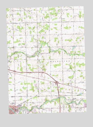
Wacousta, MI USGS Topographic Map
Click on map above to begin viewing in our Map Viewer.

This topographic map contains these locations and features:
Feature Name Type Latitude Longitude GNIS ID View Map
Abrams Municipal AirportAirportN42.7736°W84.7324°1623922View Map
Bible Missionary ChurchChurchN42.7561°W84.7372°2574583View Map
Blake's Opera House Historical MarkerParkN42.7551°W84.7431°2569701View Map
Boughton DrainCanalN42.8600°W84.7192°621771View Map
Carrier CreekStreamN42.7600°W84.6544°622783View Map
Charter Township of WatertownCivilN42.8134°W84.6613°1627221View Map
City of Grand LedgeCivilN42.7535°W84.7448°1626372View Map
Clark FarmsLocaleN42.8125°W84.7319°2725244View Map
Country Village Mobile Home ParkPopulated PlaceN42.7833°W84.6778°2574601View Map
Cutler DrainCanalN42.8353°W84.6880°624253View Map
Delta MillsPopulated PlaceN42.7650°W84.6475°624537View Map
Delta Mills Historical MarkerParkN42.7609°W84.6470°2569683View Map
Delta Mills ParkParkN42.7594°W84.6509°2585553View Map
Delta Mills SchoolSchoolN42.7653°W84.6464°2585554View Map
Delta Post Office (historical)Post OfficeN42.7653°W84.6472°2575086View Map
Delta Station (historical)LocaleN42.7650°W84.6475°2575060View Map
DeWitt Rest AreaLocaleN42.7975°W84.7150°2573865View Map
Farrier DrainCanalN42.8692°W84.6414°625850View Map
First United Methodist ChurchChurchN42.7525°W84.7478°2574580View Map
Governor Frank D Fitzgerald Home Historical MarkerParkN42.7543°W84.7475°2569704View Map
Grand LedgePopulated PlaceN42.7534°W84.7464°627094View Map
Grand Ledge Ambulance ServiceBuildingN42.7572°W84.7392°2635951View Map
Grand Ledge Area Fire DepartmentBuildingN42.7572°W84.7393°2574588View Map
Grand Ledge City HallBuildingN42.7522°W84.7456°2574596View Map
Grand Ledge Historical MuseumBuildingN42.7525°W84.7497°2574597View Map
Grand Ledge LibraryBuildingN42.7528°W84.7453°2574594View Map
Grand Ledge Police DepartmentBuildingN42.7553°W84.7405°2574589View Map
Grand Ledge Post OfficePost OfficeN42.7526°W84.7459°2574595View Map
Grand Ledge Rest AreaLocaleN42.7975°W84.7150°2573864View Map
Grand Ledge Seventh-Day Adventist ChurchChurchN42.7631°W84.7408°2574584View Map
Grand Ledge StationLocaleN42.7586°W84.7392°2574629View Map
Great Lakes Christian CollegeSchoolN42.7542°W84.6389°2585550View Map
Greenwood SchoolSchoolN42.7556°W84.7403°627395View Map
Hawk Meadows ParkParkN42.7681°W84.6356°2585555View Map
Hillside CemeteryCemeteryN42.7640°W84.6418°628325View Map
Hoerners Corners AirportAirportN42.8659°W84.7035°1623869View Map
Hunters Orchard ParkParkN42.7667°W84.6611°2585552View Map
Husted Landenburg DrainCanalN42.7861°W84.7367°628886View Map
Imperial Mobile HomesPopulated PlaceN42.7619°W84.7444°2574598View Map
Ingersoll Post Office (historical)Post OfficeN42.7728°W84.6475°2573847View Map
Ingersoll Station (historical)LocaleN42.7728°W84.6475°2573830View Map
Interchange 86CrossingN42.8000°W84.7394°2573861View Map
Interchange 90CrossingN42.7856°W84.6711°2573862View Map
Ledges Adventist Elementary SchoolSchoolN42.7631°W84.7408°2574585View Map
Leon W Hayes SchoolSchoolN42.7506°W84.7003°2574600View Map
Looking Glass Regional Fire Authority Fire StationBuildingN42.7870°W84.6760°2636247View Map
Michigan's Capitol Historical MarkerParkN42.7977°W84.7151°2568545View Map
Miller CreekStreamN42.7564°W84.6992°632362View Map
Niles CemeteryCemeteryN42.8122°W84.7497°633413View Map
Oakwood CemeteryCemeteryN42.7567°W84.7333°633913View Map
Openlander DrainCanalN42.8128°W84.6994°634077View Map
Reed DrainCanalN42.7795°W84.7300°635755View Map
S and J FarmsLocaleN42.8583°W84.7103°2725251View Map
Second Island Historical MarkerParkN42.7547°W84.7454°2569705View Map
Shadduck DrainCanalN42.8128°W84.7336°637625View Map
Smith DrainCanalN42.8370°W84.6672°638141View Map
South RileyPopulated PlaceN42.8600°W84.6614°638403View Map
South Riley CemeteryCemeteryN42.8634°W84.6413°638404View Map
South Riley ChurchChurchN42.8711°W84.6508°2573821View Map
South Riley Post Office (historical)Post OfficeN42.8600°W84.6614°2573834View Map
South Riley SchoolSchoolN42.8709°W84.6519°638405View Map
Stace DrainCanalN42.8009°W84.6533°638691View Map
Sun TheatreBuildingN42.7530°W84.7471°2741958View Map
Trinity Episcopal ChurchChurchN42.7522°W84.7450°2574579View Map
WacoustaPopulated PlaceN42.8278°W84.7008°1615648View Map
Wacousta CemeteryCemeteryN42.8213°W84.6966°2573875View Map
Wacousta Census Designated PlaceCensusN42.8202°W84.6907°2583768View Map
Wacousta Community United Methodist ChurchChurchN42.8281°W84.7042°2573767View Map
Wacousta Post Office (historical)Post OfficeN42.8278°W84.7008°2573831View Map
Warren SchoolSchoolN42.7625°W84.7414°1615786View Map
Watson and Summers DrainCanalN42.7989°W84.6455°1615872View Map
West Bend FarmsLocaleN42.8369°W84.7217°2725252View Map
Willow Ridge Elementary SchoolSchoolN42.7547°W84.7003°2574599View Map
Wilson DrainCanalN42.8684°W84.6586°1616569View Map
Wood Haven Center SchoolSchoolN42.7848°W84.6280°1616722View Map
WQHH-FM (DeWitt)TowerN42.8511°W84.6669°1625683View Map

Note: Coordinates in the location and feature list above are referenced to NAD83 datum.


Copyright (C) 2008-2024 Ryan Niemi / Sunset Dynamics ... All Rights Reserved