TopoQuest Logo
Do you find TopoQuest useful?
Help keep TopoQuest running and adding new maps/features by donating!
Bitcoin:  19c7KJd3qBynnjoSw5npx9KScwjBe4ifkT
Litecoin:  LXs6TkuXGGXo1vDsWCkWVdjQX94eUKd6ui
Home View Maps Find Maps Find Places Resources & Links


Vintondale, Pennsylvania Topographic Map

USGS Map Title: Vintondale, PA
USGS Map MRC: 40078D8
DRG (GeoTIFF) Download: o40078d8.tif


Neighboring USGS Topographic Map Quads:


  Brush Valley, PA  
40079E1
 

  Strongstown, PA  
40078E8
 

  Colver, PA  
40078E7
 

  New Florence, PA  
40079D1
 

  Vintondale, PA  
40078D8
 

  Nanty Glo, PA  
40078D7
 

  Rachelwood, PA  
40079C1
 

  Johnstown, PA  
40078C8
 

  Geistown, PA  
40078C7


Map MRC Location:

N41°
W79°
N41°
W78°
H8 H7 H6 H5 H4 H3 H2 H1
G8 G7 G6 G5 G4 G3 G2 G1
F8 F7 F6 F5 F4 F3 F2 F1
E8 E7 E6 E5 E4 E3 E2 E1
D8 D7 D6 D5 D4 D3 D2 D1
C8 C7 C6 C5 C4 C3 C2 C1
B8 B7 B6 B5 B4 B3 B2 B1
A8 A7 A6 A5 A4 A3 A2 A1
N40°
W79°
N40°
W78°

Vintondale, PA USGS 1:24K Topographic Map Preview:
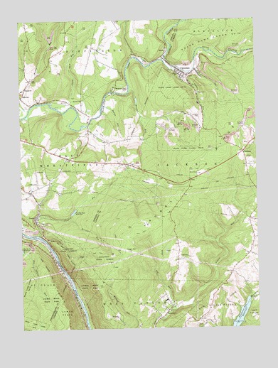
Vintondale, PA USGS Topographic Map
Click on map above to begin viewing in our Map Viewer.

This topographic map contains these locations and features:
Feature Name Type Latitude Longitude GNIS ID View Map
Blacklick ChurchChurchN40.4681°W78.9673°1169761View Map
Borough of VintondaleCivilN40.4795°W78.9114°1215037View Map
Bowserdale ChurchChurchN40.3815°W78.9231°1170079View Map
Bracken RunStreamN40.4806°W78.9070°1170112View Map
Buffington DamDamN40.4684°W78.9381°1194837View Map
Charles F Lewis Natural AreaParkN40.4056°W78.9756°1209269View Map
Charles F Lewis Natural AreaAreaN40.4059°W78.9622°1214262View Map
ChickareePopulated PlaceN40.4459°W78.8817°1171769View Map
Clark RunStreamN40.4109°W78.9864°1171917View Map
Clark Run TrailTrailN40.4109°W78.9811°1209270View Map
Clarke RunStreamN40.4651°W78.9811°1171926View Map
Conemaugh FurnaceLocaleN40.4112°W78.9886°1201172View Map
Conemaugh GorgeValleyN40.4142°W78.9992°1192288View Map
CramerPopulated PlaceN40.4198°W78.9925°1172611View Map
Delano SchoolSchoolN40.4781°W78.9156°1173121View Map
Findley RunStreamN40.4128°W78.9903°1174757View Map
Findley Run DamDamN40.4217°W78.9731°1194797View Map
Findley Run ReservoirReservoirN40.4224°W78.9720°1174758View Map
Gas CenterLocaleN40.4473°W78.9848°1212072View Map
Hinckston Run ReservoirReservoirN40.3799°W78.8840°1177134View Map
Laurel Highlands LandfillLocaleN40.4547°W78.9061°2725989View Map
Laurel Highlands TrailTrailN40.3920°W78.9811°1209273View Map
Laurel RidgeRidgeN40.4140°W78.9370°1178963View Map
Laurel Run DamDamN40.3848°W78.9159°1212794View Map
Laurel Run ReservoirReservoirN40.3848°W78.9147°1179027View Map
Memorial ChurchChurchN40.4723°W78.9973°1180900View Map
North Branch Blacklick CreekStreamN40.4840°W78.9234°1182525View Map
Pleasant Valley Golf CourseLocaleN40.4562°W78.9603°1206134View Map
Rager MountainSummitN40.4065°W78.9431°1184596View Map
Ramsey RunStreamN40.4637°W78.9561°1184634View Map
Red RunStreamN40.3826°W78.9186°1184782View Map
RexisPopulated PlaceN40.4865°W78.9222°1184961View Map
Risinger RunStreamN40.4192°W78.9736°1185107View Map
Roger Mountain TrailTrailN40.4001°W78.9714°1209271View Map
Rummel RunStreamN40.4734°W78.9411°1185615View Map
Shuman RunStreamN40.4790°W78.9097°1187633View Map
South Branch Blacklick CreekStreamN40.4840°W78.9234°1188014View Map
State Forest LandsForestN40.4051°W78.9497°1209198View Map
State Game Lands Number 42ParkN40.3884°W78.9973°1209274View Map
State Game Lands Number 79ParkN40.4923°W78.8972°1188535View Map
Township of West TaylorCivilN40.3794°W78.9389°1216100View Map
VintondalePopulated PlaceN40.4815°W78.9186°1190437View Map
Vintondale Post OfficePost OfficeN40.4781°W78.9116°2779889View Map
Vintondale Volunteer Fire Company Station 45BuildingN40.4788°W78.9127°2645755View Map
WeberLocaleN40.4856°W78.8914°1201173View Map
WehrumPopulated PlaceN40.4709°W78.9497°1204911View Map
WheatfieldLocaleN40.4551°W78.9636°1212099View Map

Note: Coordinates in the location and feature list above are referenced to NAD83 datum.


Copyright (C) 2008-2024 Ryan Niemi / Sunset Dynamics ... All Rights Reserved