TopoQuest Logo
Do you find TopoQuest useful?
Help keep TopoQuest running and adding new maps/features by donating!
Bitcoin:  19c7KJd3qBynnjoSw5npx9KScwjBe4ifkT
Litecoin:  LXs6TkuXGGXo1vDsWCkWVdjQX94eUKd6ui
Home View Maps Find Maps Find Places Resources & Links


Verde Hot Springs, Arizona Topographic Map

USGS Map Title: Verde Hot Springs, AZ
USGS Map MRC: 34111C6
DRG (GeoTIFF) Download: o34111c6.tif


Neighboring USGS Topographic Map Quads:


  Horner Mountain, AZ  
34111D7
 

  Hackberry Mountain, AZ  
34111D6
 

  Strawberry, AZ  
34111D5
 

  Tule Mesa, AZ  
34111C7
 

  Verde Hot Springs, AZ  
34111C6
 

  Cane Springs Mountain, AZ  
34111C5
 

  Bloody Basin, AZ  
34111B7
 

  Wet Bottom Mesa, AZ  
34111B6
 

  Cypress Butte, AZ  
34111B5


Map MRC Location:

N35°
W112°
N35°
W111°
H8 H7 H6 H5 H4 H3 H2 H1
G8 G7 G6 G5 G4 G3 G2 G1
F8 F7 F6 F5 F4 F3 F2 F1
E8 E7 E6 E5 E4 E3 E2 E1
D8 D7 D6 D5 D4 D3 D2 D1
C8 C7 C6 C5 C4 C3 C2 C1
B8 B7 B6 B5 B4 B3 B2 B1
A8 A7 A6 A5 A4 A3 A2 A1
N34°
W112°
N34°
W111°

Verde Hot Springs, AZ USGS 1:24K Topographic Map Preview:
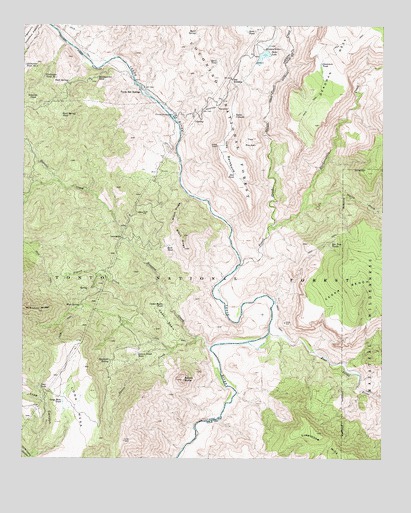
Verde Hot Springs, AZ USGS Topographic Map
Click on map above to begin viewing in our Map Viewer.

This topographic map contains these locations and features:
Feature Name Type Latitude Longitude GNIS ID View Map
Baby SnaggletoothRapidsN34.3331°W111.6960°1852417View Map
Beck TankReservoirN34.3113°W111.7008°26163View Map
Bee Tree TanksReservoirN34.3112°W111.6438°26180View Map
Black RidgeRidgeN34.3175°W111.6988°26441View Map
Cedar BasinBasinN34.2900°W111.7004°27395View Map
Cedar Basin TankReservoirN34.2943°W111.7017°27397View Map
Childs CampgroundLocaleN34.3474°W111.6972°2669954View Map
Childs PowerplantLocaleN34.3498°W111.6990°27578View Map
Childs Powerplant TankReservoirN34.3548°W111.6929°38331View Map
Childs RapidRapidsN34.3461°W111.6965°1852425View Map
Coldwater Tank Number OneReservoirN34.3604°W111.7433°27809View Map
Deadman TankReservoirN34.3639°W111.6474°28341View Map
Deer TankReservoirN34.2705°W111.7449°28398View Map
East Verde RiverStreamN34.2864°W111.6649°28796View Map
Fossil CreekStreamN34.3059°W111.6754°29132View Map
Hardscrabble CanyonValleyN34.3161°W111.6651°39491View Map
Hardscrabble CreekStreamN34.3164°W111.6657°29746View Map
Headquarter TankReservoirN34.3598°W111.7251°29833View Map
Hells HoleValleyN34.3223°W111.6532°29876View Map
Horse Camp CanyonValleyN34.2500°W111.7479°30124View Map
Houston CreekStreamN34.2820°W111.6854°30243View Map
Ike SaddleGapN34.3598°W111.6788°30320View Map
Ikes BackboneRidgeN34.3384°W111.6804°30322View Map
Ikes TankReservoirN34.3323°W111.6772°30323View Map
LancasterPopulated PlaceN34.3136°W111.7154°30864View Map
Long MesaSummitN34.2648°W111.7315°31252View Map
Long Mesa TankReservoirN34.2667°W111.7367°31253View Map
Mountain Ranch Trail Number TenTrailN34.2998°W111.7415°38648View Map
Mud SpringSpringN34.2942°W111.7308°32119View Map
Pigeon CreekStreamN34.3011°W111.7032°32892View Map
Quail SpringSpringN34.3730°W111.6911°33251View Map
Quail TankReservoirN34.3647°W111.6836°33256View Map
Red Wall RapidRapidsN34.2609°W111.6888°1852421View Map
Roadside SpringSpringN34.2786°W111.7205°33662View Map
Rock SpringSpringN34.3589°W111.7351°33726View Map
Rock Spring TankReservoirN34.3493°W111.7376°33733View Map
Sinkhole TankReservoirN34.3535°W111.7476°34463View Map
Squaw ButteSummitN34.2728°W111.6951°34761View Map
Squaw CreekStreamN34.2853°W111.6901°34764View Map
Squaw Creek TankReservoirN34.2805°W111.7108°34769View Map
State of ArizonaCivilN34.2931°W111.6645°1779777View Map
Stehr LakeReservoirN34.3662°W111.6674°34826View Map
Stehr Lake DamDamN34.3639°W111.6696°38844View Map
Stehr TankReservoirN34.3734°W111.6733°34827View Map
Tanko CalienteReservoirN34.3491°W111.6775°35144View Map
The PocketBasinN34.3414°W111.6735°35238View Map
Verde Hot SpringsSpringN34.3553°W111.7099°35765View Map
Verde Wild River AreaParkN34.2958°W111.6736°2076224View Map
Warm SpringSpringN34.2542°W111.6915°1852419View Map

Note: Coordinates in the location and feature list above are referenced to NAD83 datum.


Copyright (C) 2008-2024 Ryan Niemi / Sunset Dynamics ... All Rights Reserved