TopoQuest Logo
Do you find TopoQuest useful?
Help keep TopoQuest running and adding new maps/features by donating!
Bitcoin:  19c7KJd3qBynnjoSw5npx9KScwjBe4ifkT
Litecoin:  LXs6TkuXGGXo1vDsWCkWVdjQX94eUKd6ui
Home View Maps Find Maps Find Places Resources & Links


Bogachiel Peak, Washington Topographic Map

USGS Map Title: Bogachiel Peak, WA
USGS Map MRC: 47123H7
DRG (GeoTIFF) Download: o47123h7.tif


Neighboring USGS Topographic Map Quads:


  Mount Muller, WA  
48123A8
 

  Lake Crescent, WA  
48123A7
 

  Lake Sutherland, WA  
48123A6
 

  Slide Peak, WA  
47123H8
 

  Bogachiel Peak, WA  
47123H7
 

  Mount Carrie, WA  
47123H6
 

  Owl Mountain, WA  
47123G8
 

  Mount Tom, WA  
47123G7
 

  Mount Olympus, WA  
47123G6


Map MRC Location:

N48°
W124°
N48°
W123°
H8 H7 H6 H5 H4 H3 H2 H1
G8 G7 G6 G5 G4 G3 G2 G1
F8 F7 F6 F5 F4 F3 F2 F1
E8 E7 E6 E5 E4 E3 E2 E1
D8 D7 D6 D5 D4 D3 D2 D1
C8 C7 C6 C5 C4 C3 C2 C1
B8 B7 B6 B5 B4 B3 B2 B1
A8 A7 A6 A5 A4 A3 A2 A1
N47°
W124°
N47°
W123°

Bogachiel Peak, WA USGS 1:24K Topographic Map Preview:
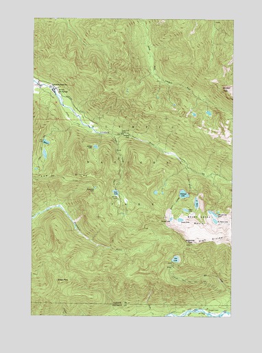
Bogachiel Peak, WA USGS Topographic Map
Click on map above to begin viewing in our Map Viewer.

This topographic map contains these locations and features:
Feature Name Type Latitude Longitude GNIS ID View Map
Bogachiel LakeLakeN47.9288°W123.8368°1516753View Map
Bogachiel ParkFlatN47.9454°W123.8688°1530098View Map
Bogachiel PeakSummitN47.9054°W123.7774°1516754View Map
Boulder Lake ShelterLocaleN47.9781°W123.7505°1516848View Map
Boulder PeakSummitN47.9717°W123.7580°1516853View Map
Canyon CreekStreamN47.9512°W123.8266°1517342View Map
Canyon Creek Hoh TrailTrailN47.8901°W123.7835°1517359View Map
Canyon Creek ShelterLocaleN47.9518°W123.8199°1517362View Map
Clear LakeLakeN47.9196°W123.7801°1517837View Map
Deer LakeLakeN47.9267°W123.8238°1518634View Map
Deer Lake CutoffTrailN47.9315°W123.8530°1518636View Map
Deer Lake ShelterLocaleN47.9245°W123.8221°1518638View Map
Deer Lake TrailTrailN47.9370°W123.8213°1518639View Map
Green PeakSummitN47.8891°W123.8579°1520321View Map
Hidden LakeLakeN47.9458°W123.8368°1520756View Map
High DivideRidgeN47.9053°W123.7774°1520777View Map
Hoh CreekStreamN47.8768°W123.7532°1520841View Map
Hoh LakeLakeN47.8989°W123.7861°1520844View Map
Long LakeLakeN47.9226°W123.7734°1522399View Map
Lovers LaneTrailN47.9562°W123.8510°1522524View Map
Lunch LakeLakeN47.9155°W123.7834°1522579View Map
Mink LakeLakeN47.9477°W123.8680°1523240View Map
Mink Lake TrailTrailN47.9431°W123.8708°1523241View Map
Morgenroth LakeLakeN47.9182°W123.7630°1534599View Map
No Name LakeLakeN47.9151°W123.7617°1523695View Map
Olympus Guard StationLocaleN47.8781°W123.7655°1524046View Map
Olympus Ranger StationLocaleN47.8790°W123.7646°1529533View Map
Round LakeLakeN47.9158°W123.7892°1525233View Map
Seven Lakes BasinBasinN47.9154°W123.7719°1525585View Map
Seven Lakes CreekStreamN47.9379°W123.7796°1525584View Map
Seven Lakes Ranger StationLocaleN47.9168°W123.7844°1529534View Map
Sol Duc FallsFallsN47.9506°W123.8152°1526098View Map
Sol Duc Hot SpringsLocaleN47.9701°W123.8624°1526095View Map
Sol Duc LakeLakeN47.9263°W123.7815°1526099View Map
Solduc Post Office (historical)Post OfficeN47.9701°W123.8624°2027199View Map
Soleduck CampgroundLocaleN47.9668°W123.8580°1529535View Map
Soleduck Ranger StationLocaleN47.9723°W123.8638°1526101View Map
Soleduck TrailTrailN47.9362°W123.7752°1526103View Map
Upper Hoh River TrailTrailN47.8765°W123.7838°1527633View Map
Y LakeLakeN47.9189°W123.7597°1530531View Map

Note: Coordinates in the location and feature list above are referenced to NAD83 datum.


Copyright (C) 2008-2024 Ryan Niemi / Sunset Dynamics ... All Rights Reserved