TopoQuest Logo
Do you find TopoQuest useful?
Help keep TopoQuest running and adding new maps/features by donating!
Bitcoin:  19c7KJd3qBynnjoSw5npx9KScwjBe4ifkT
Litecoin:  LXs6TkuXGGXo1vDsWCkWVdjQX94eUKd6ui
Home View Maps Find Maps Find Places Resources & Links


Vallecito Reservoir, Colorado Topographic Map

USGS Map Title: Vallecito Reservoir, CO
USGS Map MRC: 37107D5
DRG (GeoTIFF) Download: o37107d5.tif


Neighboring USGS Topographic Map Quads:


  Mountain View Crest, CO  
37107E6
 

  Columbine Pass, CO  
37107E5
 

  Emerald Lake, CO  
37107E4
 

  Lemon Reservoir, CO  
37107D6
 

  Vallecito Reservoir, CO  
37107D5
 

  Granite Peak, CO  
37107D4
 

  Rules Hill, CO  
37107C6
 

  Ludwig Mountain, CO  
37107C5
 

  Baldy Mountain, CO  
37107C4


Map MRC Location:

N38°
W108°
N38°
W107°
H8 H7 H6 H5 H4 H3 H2 H1
G8 G7 G6 G5 G4 G3 G2 G1
F8 F7 F6 F5 F4 F3 F2 F1
E8 E7 E6 E5 E4 E3 E2 E1
D8 D7 D6 D5 D4 D3 D2 D1
C8 C7 C6 C5 C4 C3 C2 C1
B8 B7 B6 B5 B4 B3 B2 B1
A8 A7 A6 A5 A4 A3 A2 A1
N37°
W108°
N37°
W107°

Vallecito Reservoir, CO USGS 1:24K Topographic Map Preview:
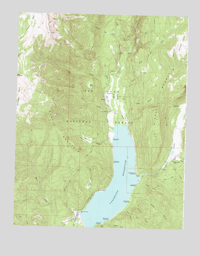
Vallecito Reservoir, CO USGS Topographic Map
Click on map above to begin viewing in our Map Viewer.

This topographic map contains these locations and features:
Feature Name Type Latitude Longitude GNIS ID View Map
Aspen Point Picnic AreaLocaleN37.4136°W107.5523°184020View Map
Bayfield DivisionCivilN37.3800°W107.5871°1935405View Map
Bear CreekStreamN37.4872°W107.5384°183999View Map
Berri CreekStreamN37.4364°W107.5448°184030View Map
Blind CanyonValleyN37.3860°W107.5442°184012View Map
Chain LakesLakeN37.4500°W107.5589°184029View Map
D CreekStreamN37.4536°W107.5545°183995View Map
Dark CanyonValleyN37.4479°W107.5431°184027View Map
Dunsworth ParkFlatN37.4000°W107.5701°184017View Map
East CreekStreamN37.4164°W107.5106°184001View Map
Fall CreekStreamN37.4778°W107.5439°183997View Map
Freeman CreekStreamN37.4258°W107.5542°184021View Map
Freeman Creek Picnic AreaLocaleN37.4269°W107.5539°184023View Map
Freeman ParkFlatN37.4264°W107.5720°184022View Map
Graham CreekStreamN37.3903°W107.5409°184004View Map
Graham Creek CampgroundLocaleN37.3906°W107.5398°184013View Map
Grimes CreekStreamN37.4356°W107.5467°184031View Map
Gut CanyonValleyN37.3775°W107.5601°184006View Map
Jack CreekStreamN37.3767°W107.5798°184009View Map
Lake EileenLakeN37.4585°W107.5719°184033View Map
Lion CreekStreamN37.4131°W107.5137°184002View Map
Little CreekStreamN37.4003°W107.5323°184014View Map
Lost CreekStreamN37.4344°W107.5542°184025View Map
Middle MountainSummitN37.4697°W107.5081°184035View Map
Middle Mountain CampgroundLocaleN37.4072°W107.5356°184018View Map
North CanyonValleyN37.3925°W107.5389°184003View Map
North Canyon CampgroundLocaleN37.3939°W107.5389°197159View Map
Old Timbers CampgroundLocaleN37.3769°W107.5603°184010View Map
Pine Point CampgroundLocaleN37.4006°W107.5353°184015View Map
Pine River CampgroundLocaleN37.4472°W107.5051°184028View Map
Root CreekStreamN37.3947°W107.5659°184016View Map
Runlett ParkFlatN37.4847°W107.5048°202971View Map
South Bear CreekStreamN37.4656°W107.5489°184000View Map
Upper Pine River Fire Protection District Station 2BuildingN37.3808°W107.5790°2667094View Map
VallecitoPopulated PlaceN37.3753°W107.5839°196405View Map
Vallecito CampgroundLocaleN37.4764°W107.5470°184034View Map
Vallecito CreekStreamN37.4358°W107.5434°183998View Map
Vallecito DamDamN37.3775°W107.5734°200714View Map
Vallecito Guard StationLocaleN37.4428°W107.5573°184026View Map
Vallecito Post Office (historical)Post OfficeN37.3753°W107.5839°2026915View Map
Vallecito ReservoirReservoirN37.4010°W107.5514°202972View Map
Weasel Skin CreekStreamN37.4878°W107.5498°183996View Map
West MountainSummitN37.4503°W107.5998°184024View Map
Wilderness Trails RanchLocaleN37.4153°W107.5089°184019View Map
Wilson CreekStreamN37.3794°W107.5570°184005View Map
Wilson Creek CampgroundLocaleN37.3797°W107.5548°184011View Map
Wits End RanchLocaleN37.4533°W107.5598°184032View Map

Note: Coordinates in the location and feature list above are referenced to NAD83 datum.


Copyright (C) 2008-2024 Ryan Niemi / Sunset Dynamics ... All Rights Reserved