TopoQuest Logo
Do you find TopoQuest useful?
Help keep TopoQuest running and adding new maps/features by donating!
Bitcoin:  19c7KJd3qBynnjoSw5npx9KScwjBe4ifkT
Litecoin:  LXs6TkuXGGXo1vDsWCkWVdjQX94eUKd6ui
Home View Maps Find Maps Find Places Resources & Links


Tuskeegee, North Carolina Topographic Map

USGS Map Title: Tuskeegee, NC
USGS Map MRC: 35083D6
DRG (GeoTIFF) Download: o35083d6.tif


Neighboring USGS Topographic Map Quads:


  Cades Cove, TN  
35083E7
 

  Thunderhead Mountain, NC  
35083E6
 

  Silers Bald, NC  
35083E5
 

  Fontana Dam, NC  
35083D7
 

  Tuskeegee, NC  
35083D6
 

  Noland Creek, NC  
35083D5
 

  Robbinsville, NC  
35083C7
 

  Hewitt, NC  
35083C6
 

  Wesser, NC  
35083C5


Map MRC Location:

N36°
W84°
N36°
W83°
H8 H7 H6 H5 H4 H3 H2 H1
G8 G7 G6 G5 G4 G3 G2 G1
F8 F7 F6 F5 F4 F3 F2 F1
E8 E7 E6 E5 E4 E3 E2 E1
D8 D7 D6 D5 D4 D3 D2 D1
C8 C7 C6 C5 C4 C3 C2 C1
B8 B7 B6 B5 B4 B3 B2 B1
A8 A7 A6 A5 A4 A3 A2 A1
N35°
W84°
N35°
W83°

Tuskeegee, NC USGS 1:24K Topographic Map Preview:
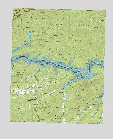
Tuskeegee, NC USGS Topographic Map
Click on map above to begin viewing in our Map Viewer.

This topographic map contains these locations and features:
Feature Name Type Latitude Longitude GNIS ID View Map
Apple Tree BranchStreamN35.4073°W83.7302°980260View Map
Bailey BranchStreamN35.4256°W83.6913°980425View Map
Bearpen BranchStreamN35.4770°W83.7371°980750View Map
Bearpen GapGapN35.4262°W83.7421°980756View Map
Big BranchStreamN35.3873°W83.7374°981336View Map
Big BranchStreamN35.3931°W83.6421°981337View Map
Big ButteSummitN35.4695°W83.7457°1019124View Map
Big Elk KnobSummitN35.3985°W83.7271°1019130View Map
Big Fork RidgeRidgeN35.4881°W83.6295°1009321View Map
Big RidgeRidgeN35.4955°W83.7219°981442View Map
Blankenship CemeteryCemeteryN35.4134°W83.7227°981587View Map
Bluff BranchStreamN35.4437°W83.6446°981643View Map
Boelinger BranchStreamN35.4012°W83.7074°981675View Map
Bone Valley CemeteryCemeteryN35.4998°W83.6824°981712View Map
Bone Valley CreekStreamN35.4990°W83.6804°981713View Map
Bradshaw CemeteryCemeteryN35.4787°W83.7310°981813View Map
Breedlove CemeteryCemeteryN35.4112°W83.7185°981850View Map
Briggs Garland CoveValleyN35.3824°W83.6806°981896View Map
Briggs Garland GapGapN35.3804°W83.6910°1018036View Map
BrockLocaleN35.3948°W83.7168°1023550View Map
Brown ForkStreamN35.3831°W83.7402°1009656View Map
Cable BranchStreamN35.4554°W83.7446°1009885View Map
Cable CemeteryCemeteryN35.3751°W83.6416°982391View Map
Cable CoveValleyN35.4379°W83.7477°1009887View Map
Cable GapGapN35.3756°W83.6407°982393View Map
Calhoun BranchStreamN35.4443°W83.7038°982424View Map
Chambers CreekStreamN35.4401°W83.6263°1010161View Map
Chesquaw BranchStreamN35.4406°W83.6891°983094View Map
Chestnut Log BranchStreamN35.4081°W83.7177°983114View Map
Chestnut Log GapGapN35.4001°W83.7160°983115View Map
Cindy BranchStreamN35.4065°W83.7385°983195View Map
Clark BranchStreamN35.4426°W83.6718°983211View Map
Cody BranchStreamN35.3793°W83.6624°983332View Map
Cook-Mill Creek CemeteryCemeteryN35.4517°W83.7020°2775236View Map
Coot CoveValleyN35.4495°W83.6652°983517View Map
Deep GapGapN35.4687°W83.6757°984075View Map
DeLozier GapGapN35.4818°W83.6413°984025View Map
Edwards CemeteryCemeteryN35.3756°W83.6813°984655View Map
Fairview CemeteryCemeteryN35.4474°W83.7088°984908View Map
Firescald RidgeRidgeN35.4314°W83.7390°985077View Map
Fontana LakeReservoirN35.4292°W83.6469°1011304View Map
Garland BranchStreamN35.4231°W83.6943°985571View Map
Gunlock RidgeRidgeN35.4903°W83.6686°986258View Map
Gunter CemeteryCemeteryN35.4070°W83.7352°986262View Map
Haw Gap BranchStreamN35.4940°W83.6891°986515View Map
Hickory BottomFlatN35.4848°W83.7307°986687View Map
Hickory Bottom BranchStreamN35.4756°W83.7332°986688View Map
Hickory CoveValleyN35.4803°W83.6904°986692View Map
Higdon CemeteryCemeteryN35.4989°W83.6953°986737View Map
Hogback MountainSummitN35.3848°W83.6959°1020792View Map
Horseshoe RidgeRidgeN35.4962°W83.7218°987146View Map
Hyde BranchStreamN35.4379°W83.6988°987309View Map
Indian Camp BranchStreamN35.4348°W83.7482°987338View Map
Johnson CemeteryCemeteryN35.3945°W83.7166°987662View Map
Johnson GapGapN35.3787°W83.7102°987678View Map
Johnson Gap BranchStreamN35.3959°W83.7149°987679View Map
Kirkland BranchStreamN35.4431°W83.6360°988021View Map
Laurel BranchStreamN35.3876°W83.6521°988172View Map
Laurel BranchStreamN35.4179°W83.6710°988174View Map
Laurel BranchStreamN35.4654°W83.7207°988176View Map
Licklog GapGapN35.4845°W83.6629°988462View Map
Little BranchStreamN35.3834°W83.6568°988547View Map
Little Elk KnobSummitN35.4054°W83.7101°1021184View Map
Little Laurel BranchStreamN35.4187°W83.6693°988692View Map
Loudermilk RidgeRidgeN35.4820°W83.6617°989037View Map
Lovin Entry BranchStreamN35.4179°W83.6291°989074View Map
Maggie Cable CemeteryCemeteryN35.4513°W83.7211°982392View Map
Maple BranchStreamN35.4148°W83.7127°989297View Map
Medlin BranchStreamN35.3895°W83.6491°989702View Map
Meetinghouse BranchStreamN35.4254°W83.6502°989706View Map
Meetinghouse MountainSummitN35.4039°W83.6596°1021408View Map
Mill BranchStreamN35.4470°W83.7029°989873View Map
Mitchel CemeteryCemeteryN35.4504°W83.6820°990091View Map
Nelms Family CemeteryCemeteryN35.4485°W83.7053°2775284View Map
North Fork Tuskeegee CreekStreamN35.4065°W83.7385°1014011View Map
Owensby BranchStreamN35.4329°W83.6760°991756View Map
Pendleton CreekStreamN35.4281°W83.6449°992021View Map
Perry KnobSummitN35.4179°W83.7474°1021869View Map
Pikey CemeteryCemeteryN35.4534°W83.6664°992204View Map
Pilkey CreekStreamN35.4368°W83.6729°992205View Map
Pine Gap BranchStreamN35.4790°W83.6974°992237View Map
Pinnacle RidgeRidgeN35.4983°W83.7260°1014475View Map
Poison Cove BranchStreamN35.4420°W83.7257°992621View Map
Posey CemeteryCemeteryN35.4550°W83.6610°992732View Map
Possum HollowValleyN35.4736°W83.7293°992734View Map
Powell BranchStreamN35.4406°W83.7496°1014632View Map
ProctorPopulated PlaceN35.4734°W83.7263°1022086View Map
Proctor BranchStreamN35.3981°W83.6366°992829View Map
Proctor CemeteryCemeteryN35.4745°W83.7286°992830View Map
Pullback RidgeRidgeN35.4725°W83.6773°992894View Map
Ramp CoveValleyN35.4777°W83.7465°993011View Map
Right Fork Cold Spring BranchStreamN35.4965°W83.6560°993353View Map
Roaring BranchStreamN35.4093°W83.6291°993426View Map
Rough BranchStreamN35.3762°W83.6302°1015096View Map
Rowan BranchStreamN35.4745°W83.7074°993767View Map
Sandy Gap BranchStreamN35.4804°W83.6949°994271View Map
Sawyer CreekStreamN35.4126°W83.6846°1015306View Map
Sawyer Creek CemeteryCemeteryN35.4015°W83.7057°994400View Map
Sawyer Creek ChurchChurchN35.3929°W83.7207°994401View Map
Shehan BranchStreamN35.4737°W83.7293°994630View Map
Snakeden RidgeRidgeN35.4956°W83.7369°995043View Map
Soapstone GapGapN35.4923°W83.7407°995087View Map
South Fork Sawyer CreekStreamN35.3895°W83.7346°995161View Map
South Fork Tuskeegee CreekStreamN35.4043°W83.7407°1015699View Map
Stecoah CreekStreamN35.4276°W83.6563°1015804View Map
Sugar ForkStreamN35.4987°W83.6946°995650View Map
Taylor BranchStreamN35.3973°W83.6385°995880View Map
The HorseshoeBasinN35.4876°W83.7143°1008272View Map
The PinnacleSummitN35.4983°W83.7259°1022931View Map
Tobacco BranchStreamN35.4001°W83.6299°996122View Map
Township of StecoahCivilN35.3953°W83.6799°1026710View Map
TuskeegeePopulated PlaceN35.4084°W83.7193°1023020View Map
Tuskeegee CreekStreamN35.4370°W83.6921°996374View Map
Walker GapGapN35.4651°W83.6916°996699View Map
Walnut HollowValleyN35.4263°W83.7181°996745View Map
Walnut Hollow GapGapN35.4193°W83.7138°996746View Map
Wasulu RidgeRidgeN35.4864°W83.6391°996836View Map
Welch - Kirkland CemeteryCemeteryN35.4484°W83.6369°996934View Map
Welch BaldSummitN35.4881°W83.6291°996931View Map
White Pine BranchStreamN35.3976°W83.7118°997192View Map
Whiteside CreekStreamN35.4443°W83.7207°997257View Map
Whiteside GapGapN35.4065°W83.7060°997258View Map
Wildcat GapGapN35.4087°W83.6796°997314View Map
Williams CoveBasinN35.4293°W83.7485°1016702View Map
Wolf CreekStreamN35.4023°W83.6288°997525View Map
Yellow BranchStreamN35.4406°W83.7127°997703View Map
Yellow Branch CemeteryCemeteryN35.4323°W83.7154°997704View Map

Note: Coordinates in the location and feature list above are referenced to NAD83 datum.


Copyright (C) 2008-2024 Ryan Niemi / Sunset Dynamics ... All Rights Reserved