TopoQuest Logo
Do you find TopoQuest useful?
Help keep TopoQuest running and adding new maps/features by donating!
Bitcoin:  19c7KJd3qBynnjoSw5npx9KScwjBe4ifkT
Litecoin:  LXs6TkuXGGXo1vDsWCkWVdjQX94eUKd6ui
Home View Maps Find Maps Find Places Resources & Links


Trumann, Arkansas Topographic Map

USGS Map Title: Trumann, AR
USGS Map MRC: 35090F5
DRG (GeoTIFF) Download: o35090f5.tif


Neighboring USGS Topographic Map Quads:


  Jonesboro, AR  
35090G6
 

  Needham, AR  
35090G5
 

  Lake City, AR  
35090G4
 

  Greenfield, AR  
35090F6
 

  Trumann, AR  
35090F5
 

  Hatchie Coon, AR  
35090F4
 

  Harrisburg, AR  
35090E6
 

  McCormick, AR  
35090E5
 

  Marked Tree, AR  
35090E4


Map MRC Location:

N36°
W91°
N36°
W90°
H8 H7 H6 H5 H4 H3 H2 H1
G8 G7 G6 G5 G4 G3 G2 G1
F8 F7 F6 F5 F4 F3 F2 F1
E8 E7 E6 E5 E4 E3 E2 E1
D8 D7 D6 D5 D4 D3 D2 D1
C8 C7 C6 C5 C4 C3 C2 C1
B8 B7 B6 B5 B4 B3 B2 B1
A8 A7 A6 A5 A4 A3 A2 A1
N35°
W91°
N35°
W90°

Trumann, AR USGS 1:24K Topographic Map Preview:
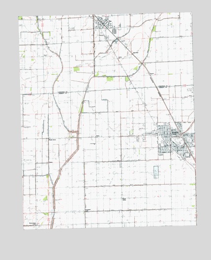
Trumann, AR USGS Topographic Map
Click on map above to begin viewing in our Map Viewer.

This topographic map contains these locations and features:
Feature Name Type Latitude Longitude GNIS ID View Map
Alsup ChurchChurchN35.7273°W90.6084°45848View Map
Alsup School (historical)SchoolN35.7265°W90.6071°82684View Map
BayPopulated PlaceN35.7423°W90.5623°76250View Map
Bay Elementary SchoolSchoolN35.7479°W90.5654°64657View Map
Bay Fire Department Station 1BuildingN35.7437°W90.5654°2116115View Map
Bay Fire Department Station 2BuildingN35.7417°W90.5495°2116116View Map
Bay High SchoolSchoolN35.7478°W90.5663°2039072View Map
Bay Police DepartmentBuildingN35.7438°W90.5650°2118515View Map
Bay Post OfficePost OfficeN35.7444°W90.5635°2781833View Map
Bay-Brown High SchoolSchoolN35.7479°W90.5654°64658View Map
Byrns School (historical)SchoolN35.6779°W90.5615°82743View Map
Campbell Civic CenterBuildingN35.6715°W90.5040°65765View Map
Carr (historical)Populated PlaceN35.6904°W90.5179°65766View Map
Cedar Park Elementary SchoolSchoolN35.6745°W90.5240°65767View Map
City of BayCivilN35.7458°W90.5541°2403823View Map
City of TrumannCivilN35.6763°W90.5230°2405607View Map
Davis SpurPopulated PlaceN35.7265°W90.5446°76752View Map
Davis Spur School (historical)SchoolN35.7242°W90.5543°75321View Map
Ditch Number 12CanalN35.6631°W90.5809°82062View Map
Ditch Number 13CanalN35.6790°W90.5543°82072View Map
Ditch Number 14CanalN35.6931°W90.5534°82082View Map
Ditch Number 15CanalN35.6787°W90.5446°82089View Map
Ditch Number 16CanalN35.6501°W90.5448°82098View Map
Ditch Number 17CanalN35.6356°W90.5523°82107View Map
Ditch Number 30CanalN35.6417°W90.5001°82211View Map
Ditch Number 5CanalN35.6567°W90.6154°82301View Map
Ditch Number 6CanalN35.6742°W90.6059°82340View Map
Ditch Number 6CanalN35.7456°W90.5457°82344View Map
Ditch Number 9CanalN35.6942°W90.5982°82414View Map
DobellPopulated PlaceN35.6829°W90.5121°57663View Map
First General ChurchChurchN35.6737°W90.5729°76317View Map
First United Methodist ChurchChurchN35.6737°W90.5171°65780View Map
First United Pentecostal ChurchChurchN35.6773°W90.5226°65781View Map
Good Luck School (historical)SchoolN35.7462°W90.5093°64679View Map
HermanLocaleN35.7151°W90.5323°81867View Map
Herman School (historical)SchoolN35.7123°W90.5304°75328View Map
Hurds ChapelChurchN35.6626°W90.6154°50424View Map
HuskeyPopulated PlaceN35.6640°W90.6059°65821View Map
KXRQ-AM (Trumann)TowerN35.6604°W90.5021°85350View Map
Longs ChapelChurchN35.6342°W90.5409°51446View Map
Maple GrovePopulated PlaceN35.6420°W90.5543°58120View Map
Maple Grove Baptist ChurchChurchN35.6423°W90.5543°65791View Map
Maple Grove School (historical)SchoolN35.6423°W90.5546°82752View Map
Melody Nursing HomeBuildingN35.6667°W90.5243°65795View Map
Merced (historical)Populated PlaceN35.6640°W90.5537°82835View Map
North Mart Shopping CenterLocaleN35.6790°W90.5251°65799View Map
North Side ParkParkN35.6809°W90.5182°65800View Map
Oak Grove School (historical)SchoolN35.6426°W90.5187°82756View Map
Ozark Street ParkParkN35.6787°W90.5079°65802View Map
Promised LandPopulated PlaceN35.6348°W90.5807°78860View Map
Promised Land School (historical)SchoolN35.6351°W90.5809°82760View Map
Ruffin (historical)Populated PlaceN35.6709°W90.5718°70137View Map
Safford Spur (historical)LocaleN35.6784°W90.5446°82761View Map
Saint Pauls CemeteryCemeteryN35.7334°W90.5509°54453View Map
Saint Pauls ChurchChurchN35.7248°W90.5543°54459View Map
Shady GrovePopulated PlaceN35.6781°W90.6065°58598View Map
Shady Grove School (historical)SchoolN35.6779°W90.6051°82762View Map
StacyPopulated PlaceN35.6784°W90.5709°58677View Map
Township of MaumelleCivilN35.7496°W90.5541°66465View Map
Township of WillisCivilN35.6626°W90.5261°68983View Map
TrumannPopulated PlaceN35.6737°W90.5073°78590View Map
Trumann Ambulance ServiceBuildingN35.6778°W90.5478°2119129View Map
Trumann City HallBuildingN35.6679°W90.5071°65809View Map
Trumann Fire StationBuildingN35.6710°W90.5184°2117223View Map
Trumann High SchoolSchoolN35.6725°W90.5324°65810View Map
Trumann Police DepartmentBuildingN35.6679°W90.5070°2118511View Map
Trumann Post OfficePost OfficeN35.6685°W90.5153°2781897View Map
Viva Drive Church of ChristChurchN35.6812°W90.5301°65812View Map
Walnut Grove ChurchChurchN35.6379°W90.6162°56006View Map
Walnut Grove CornerPopulated PlaceN35.6276°W90.6176°58821View Map
West Side ParkParkN35.6726°W90.5232°65817View Map
Whiteman CreekStreamN35.7492°W90.6129°78765View Map

Note: Coordinates in the location and feature list above are referenced to NAD83 datum.


Copyright (C) 2008-2024 Ryan Niemi / Sunset Dynamics ... All Rights Reserved