TopoQuest Logo
Do you find TopoQuest useful?
Help keep TopoQuest running and adding new maps/features by donating!
Bitcoin:  19c7KJd3qBynnjoSw5npx9KScwjBe4ifkT
Litecoin:  LXs6TkuXGGXo1vDsWCkWVdjQX94eUKd6ui
Home View Maps Find Maps Find Places Resources & Links


Thebes, Illinois Topographic Map

USGS Map Title: Thebes, IL
USGS Map MRC: 37089B4
DRG (GeoTIFF) Download: o37089b4.tif


Neighboring USGS Topographic Map Quads:


  Cape Girardeau, MO  
37089C5
 

  McClure, IL  
37089C4
 

  Mill Creek, IL  
37089C3
 

  Scott City, MO  
37089B5
 

  Thebes, IL  
37089B4
 

  Tamms, IL  
37089B3
 

  Morley, MO  
37089A5
 

  Thebes SW, MO  
37089A4
 

  Cache, IL  
37089A3


Map MRC Location:

N38°
W90°
N38°
W89°
H8 H7 H6 H5 H4 H3 H2 H1
G8 G7 G6 G5 G4 G3 G2 G1
F8 F7 F6 F5 F4 F3 F2 F1
E8 E7 E6 E5 E4 E3 E2 E1
D8 D7 D6 D5 D4 D3 D2 D1
C8 C7 C6 C5 C4 C3 C2 C1
B8 B7 B6 B5 B4 B3 B2 B1
A8 A7 A6 A5 A4 A3 A2 A1
N37°
W90°
N37°
W89°

Thebes, IL USGS 1:24K Topographic Map Preview:
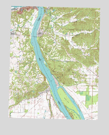
Thebes, IL USGS Topographic Map
Click on map above to begin viewing in our Map Viewer.

This topographic map contains these locations and features:
Feature Name Type Latitude Longitude GNIS ID View Map
Albrecht CreekStreamN37.1867°W89.4604°713188View Map
Alexander ChurchChurchN37.1914°W89.3901°403400View Map
Anderson CemeteryCemeteryN37.1592°W89.4476°713279View Map
Atherton LandingLocaleN37.1253°W89.3917°422202View Map
Beech Grove ChurchChurchN37.2242°W89.4373°404098View Map
Big CypressSwampN37.1495°W89.3888°404399View Map
Black Powder HollowValleyN37.1706°W89.4331°404500View Map
Bracken CemeteryCemeteryN37.2131°W89.4384°404769View Map
Brown Homestead CemeteryCemeteryN37.2325°W89.4240°2047064View Map
Brownsville CreekStreamN37.2178°W89.4248°424681View Map
Brownsville School (historical)SchoolN37.2184°W89.4245°1736133View Map
Burnham IslandIslandN37.1417°W89.4126°405239View Map
Cape LaCroix CreekStreamN37.2476°W89.4898°715381View Map
Cat IslandIslandN37.1278°W89.4404°730418View Map
CommercePopulated PlaceN37.1589°W89.4429°716151View Map
Commerce CemeteryCemeteryN37.1464°W89.4712°716152View Map
Commerce Towhead (historical)IslandN37.1726°W89.4429°1736137View Map
Cue CreekStreamN37.2131°W89.4706°716581View Map
Davis LakeReservoirN37.1767°W89.4618°765589View Map
Davis Lake DamDamN37.1767°W89.4618°765588View Map
Dorrity CreekStreamN37.2287°W89.4684°716992View Map
Dynamite HollowValleyN37.1779°W89.4405°407556View Map
FayvillePopulated PlaceN37.1648°W89.4268°422694View Map
FroemsdorfLocaleN37.2226°W89.4895°730404View Map
GalePopulated PlaceN37.2489°W89.4476°408843View Map
Gale Post OfficePost OfficeN37.2484°W89.4476°1808564View Map
Garner CemeteryCemeteryN37.2298°W89.4559°2047077View Map
Goose IslandIslandN37.1256°W89.4031°409169View Map
Grays PointCapeN37.2492°W89.4635°766159View Map
Grays Point (historical)Populated PlaceN37.2403°W89.4687°765600View Map
Grays Point CemeteryCemeteryN37.2409°W89.4690°766160View Map
Graysboro School (historical)SchoolN37.2420°W89.4684°748068View Map
Hartsook School (historical)SchoolN37.1434°W89.4037°1736140View Map
Hobbs CemeteryCemeteryN37.2298°W89.4562°410327View Map
Hobbs CreekStreamN37.2262°W89.4873°719647View Map
Holden CreekStreamN37.1895°W89.4623°719699View Map
Hutchison CemeteryCemeteryN37.2414°W89.4415°410731View Map
Illmo Junction (historical)LocaleN37.2167°W89.4729°740573View Map
Jackson HillSummitN37.1542°W89.4734°720215View Map
Joliet HollowValleyN37.2338°W89.4173°411193View Map
Jones HollowValleyN37.1648°W89.4031°411216View Map
Lightner CemeteryCemeteryN37.2098°W89.4967°721049View Map
Little Cypress Swamp (historical)SwampN37.1701°W89.3812°1736148View Map
Little IslandIslandN37.1342°W89.4126°412361View Map
Macedonia ChurchChurchN37.1706°W89.4820°730405View Map
Macedonia SchoolSchoolN37.1667°W89.4843°748069View Map
Miller CemeteryCemeteryN37.2323°W89.4242°413568View Map
Miller CreekStreamN37.2470°W89.4487°413581View Map
Mount Zion CemeteryCemeteryN37.1934°W89.3912°414109View Map
Mount Zion Church (historical)ChurchN37.1917°W89.3901°1736151View Map
New Hamburg / Benton / Commerce Fire Protection District Station 2BuildingN37.1563°W89.4490°2621771View Map
New York (historical)Populated PlaceN37.1667°W89.4448°730403View Map
North JunctionLocaleN37.2387°W89.4454°1736152View Map
Oakdale CemeteryCemeteryN37.1448°W89.4737°723555View Map
Orchard CreekStreamN37.1928°W89.4526°415160View Map
Pence School (historical)SchoolN37.1887°W89.4265°1736153View Map
Perkins SpringSpringN37.2378°W89.4368°415552View Map
Rock IslandIslandN37.2459°W89.4543°416818View Map
Rock Springs ChurchChurchN37.1895°W89.4268°416833View Map
Rock Springs HollowValleyN37.1983°W89.4515°416836View Map
Rose CreekStreamN37.2017°W89.4659°725560View Map
Rose Hill CemeteryCemeteryN37.2242°W89.4540°416940View Map
Ross CemeteryCemeteryN37.1339°W89.4440°725576View Map
Ross LakeLakeN37.1332°W89.4485°725581View Map
Rubel CreekStreamN37.1876°W89.4709°725649View Map
Saint Joseph CemeteryCemeteryN37.2109°W89.4965°725796View Map
Saint Joseph Church (historical)ChurchN37.2117°W89.4962°730402View Map
Sammons CreekStreamN37.2334°W89.4406°417915View Map
Sanders CemeteryCemeteryN37.1706°W89.4815°718328View Map
Santa Fe CemeteryCemeteryN37.1625°W89.4187°1821617View Map
Santa Fe HillsSummitN37.1801°W89.4204°418012View Map
Sawmill HollowValleyN37.2339°W89.4769°726073View Map
Sexton CreekStreamN37.2420°W89.4540°418240View Map
Shasta (historical)Populated PlaceN37.1317°W89.3951°1736157View Map
South JunctionLocaleN37.2284°W89.4484°1736158View Map
TankvillePopulated PlaceN37.1270°W89.3837°423231View Map
ThebesPopulated PlaceN37.2209°W89.4609°424100View Map
Thebes Election PrecinctCivilN37.2127°W89.4139°1928659View Map
Thebes Post OfficePost OfficeN37.2216°W89.4541°2788341View Map
Thebes Volunteer Fire DepartmentBuildingN37.2230°W89.4498°2640378View Map
Thompson CemeteryCemeteryN37.1681°W89.4295°419666View Map
Twente CemeteryCemeteryN37.1742°W89.3929°419972View Map
Twente School (historical)SchoolN37.1781°W89.3876°1736159View Map
Village of CommerceCivilN37.1583°W89.4466°2398607View Map
Village of ThebesCivilN37.2140°W89.4544°2399967View Map
WasatshLocaleN37.1401°W89.4631°748070View Map
ZewapetaPopulated PlaceN37.1695°W89.4593°730401View Map

Note: Coordinates in the location and feature list above are referenced to NAD83 datum.


Copyright (C) 2008-2024 Ryan Niemi / Sunset Dynamics ... All Rights Reserved