TopoQuest Logo
Do you find TopoQuest useful?
Help keep TopoQuest running and adding new maps/features by donating!
Bitcoin:  19c7KJd3qBynnjoSw5npx9KScwjBe4ifkT
Litecoin:  LXs6TkuXGGXo1vDsWCkWVdjQX94eUKd6ui
Home View Maps Find Maps Find Places Resources & Links


Tanwax Lake, Washington Topographic Map

USGS Map Title: Tanwax Lake, WA
USGS Map MRC: 46122H3
DRG (GeoTIFF) Download: o46122h3.tif


Neighboring USGS Topographic Map Quads:


  Spanaway, WA  
47122A4
 

  Frederickson, WA  
47122A3
 

  Orting, WA  
47122A2
 

  Harts Lake, WA  
46122H4
 

  Tanwax Lake, WA  
46122H3
 

  Lake Kapowsin, WA  
46122H2
 

  Bald Hill, WA  
46122G4
 

  Eatonville, WA  
46122G3
 

  Elbe, WA  
46122G2


Map MRC Location:

N47°
W123°
N47°
W122°
H8 H7 H6 H5 H4 H3 H2 H1
G8 G7 G6 G5 G4 G3 G2 G1
F8 F7 F6 F5 F4 F3 F2 F1
E8 E7 E6 E5 E4 E3 E2 E1
D8 D7 D6 D5 D4 D3 D2 D1
C8 C7 C6 C5 C4 C3 C2 C1
B8 B7 B6 B5 B4 B3 B2 B1
A8 A7 A6 A5 A4 A3 A2 A1
N46°
W123°
N46°
W122°

Tanwax Lake, WA USGS 1:24K Topographic Map Preview:
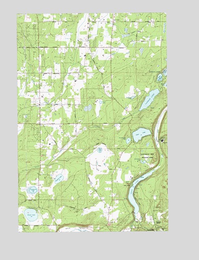
Tanwax Lake, WA USGS Topographic Map
Click on map above to begin viewing in our Map Viewer.

This topographic map contains these locations and features:
Feature Name Type Latitude Longitude GNIS ID View Map
Benbow LakesLakeN46.9651°W122.2518°1516402View Map
Benston Community ChurchChurchN46.9843°W122.3146°1516422View Map
Byron LakeLakeN46.9586°W122.2526°1517180View Map
Clay CityPopulated PlaceN46.9257°W122.2559°1517815View Map
Clear LakeLakeN46.9304°W122.2737°1517834View Map
Clear Lake Census Designated PlaceCensusN46.9312°W122.2842°2584959View Map
Cranberry LakeLakeN46.8990°W122.3637°1518272View Map
Eatonville JunctionPopulated PlaceN46.8795°W122.2623°1519162View Map
Horseshoe LakeLakeN46.9146°W122.2719°1520954View Map
Jims CornerPopulated PlaceN46.9948°W122.2946°1521383View Map
Johnsons CornerPopulated PlaceN46.9804°W122.3576°1521444View Map
Lake WhitmanLakeN46.9628°W122.2572°1528104View Map
LeberPopulated PlaceN46.9482°W122.3312°1530547View Map
Lynch CreekStreamN46.8818°W122.2790°1522604View Map
Mud LakeLakeN46.9215°W122.3079°1523472View Map
OhopLocaleN46.9068°W122.2601°1530061View Map
Ohop LakeLakeN46.9053°W122.2732°1523976View Map
Pierce County Fire District 21 Graham Fire and Rescue Station 93BuildingN46.9799°W122.3256°2619784View Map
Pierce County Sheriff's Office EatonvilleBuildingN46.8891°W122.3017°2721951View Map
Point OhopCapeN46.9012°W122.2815°1524536View Map
Rainier CemeteryCemeteryN46.8867°W122.3275°1524832View Map
Rapjohn LakeLakeN46.9052°W122.3422°1524875View Map
Silver LakeLakeN46.8849°W122.3656°1525778View Map
South Pierce Fire and Rescue Station 170 HeadquartersBuildingN46.9478°W122.3566°2619530View Map
South Pierce Fire and Rescue Station 175BuildingN46.9231°W122.2828°2619599View Map
South Pierce Fire and Rescue Station 176BuildingN46.8785°W122.3451°2619601View Map
Stidham LakeLakeN46.9514°W122.2799°1526563View Map
Tanwax Greens Golf CourseLocaleN46.9243°W122.3631°2608364View Map
Tanwax LakeReservoirN46.9502°W122.2665°1532863View Map
Tanwax Lake DamDamN46.9415°W122.2812°1532862View Map
Thompson DamDamN46.9432°W122.3446°1532591View Map
Three Hundred Fourth Street LandfillLocaleN46.9728°W122.2906°2605575View Map
Trout LakeLakeN46.9490°W122.3070°1527410View Map
Twentyfive Mile CreekStreamN46.9234°W122.2609°1527504View Map
Twentyseven LakeLakeN46.9267°W122.2840°1527512View Map
Twin LakesLakeN46.9678°W122.2501°1527544View Map
Weyerhaeuser Elementary SchoolSchoolN46.9251°W122.3496°1531179View Map

Note: Coordinates in the location and feature list above are referenced to NAD83 datum.


Copyright (C) 2008-2024 Ryan Niemi / Sunset Dynamics ... All Rights Reserved