TopoQuest Logo
Do you find TopoQuest useful?
Help keep TopoQuest running and adding new maps/features by donating!
Bitcoin:  19c7KJd3qBynnjoSw5npx9KScwjBe4ifkT
Litecoin:  LXs6TkuXGGXo1vDsWCkWVdjQX94eUKd6ui
Home View Maps Find Maps Find Places Resources & Links


Tanner Williams, Alabama Topographic Map

USGS Map Title: Tanner Williams, AL
USGS Map MRC: 30088F3
DRG (GeoTIFF) Download: o30088f3.tif


Neighboring USGS Topographic Map Quads:


  Howell, MS  
30088G4
 

  Semmes, AL  
30088G3
 

  Kushla, AL  
30088G2
 

  Hurley, MS  
30088F4
 

  Tanner Williams, AL  
30088F3
 

  Spring Hill, AL  
30088F2
 

  Big Point, MS  
30088E4
 

  Saint Elmo, AL  
30088E3
 

  Theodore, AL  
30088E2


Map MRC Location:

N31°
W89°
N31°
W88°
H8 H7 H6 H5 H4 H3 H2 H1
G8 G7 G6 G5 G4 G3 G2 G1
F8 F7 F6 F5 F4 F3 F2 F1
E8 E7 E6 E5 E4 E3 E2 E1
D8 D7 D6 D5 D4 D3 D2 D1
C8 C7 C6 C5 C4 C3 C2 C1
B8 B7 B6 B5 B4 B3 B2 B1
A8 A7 A6 A5 A4 A3 A2 A1
N30°
W89°
N30°
W88°

Tanner Williams, AL USGS 1:24K Topographic Map Preview:
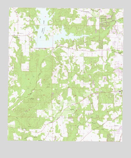
Tanner Williams, AL USGS Topographic Map
Click on map above to begin viewing in our Map Viewer.

This topographic map contains these locations and features:
Feature Name Type Latitude Longitude GNIS ID View Map
Airport Snow Shopping CenterLocaleN30.6726°W88.2775°2579139View Map
Airport West Commercial ParkLocaleN30.6711°W88.2834°2579125View Map
AlderbrookPopulated PlaceN30.6488°W88.2778°143100View Map
Allentown ChurchChurchN30.7469°W88.2936°154964View Map
Baker High SchoolSchoolN30.6717°W88.2535°165352View Map
Beaver Creek Lookout TowerTowerN30.6638°W88.3486°164282View Map
Bethel Missionary Baptist ChurchChurchN30.6253°W88.3363°114089View Map
Big Creek LakeReservoirN30.7488°W88.3353°114272View Map
Big Creek Lake DamDamN30.7085°W88.3417°129578View Map
Cottage Park EstatesPopulated PlaceN30.6285°W88.2639°143269View Map
Countryside Mobile Home ParkPopulated PlaceN30.7352°W88.2587°2579844View Map
Crossroads Baptist ChurchChurchN30.6412°W88.2596°2579548View Map
Dawes PointPopulated PlaceN30.6363°W88.2536°143291View Map
Dees CemeteryCemeteryN30.7313°W88.3597°117209View Map
Faith ChurchChurchN30.6416°W88.3325°143323View Map
Foster Grove ChurchChurchN30.7082°W88.2542°118537View Map
Gospel Lighthouse Assembly of GodChurchN30.7261°W88.2505°1729988View Map
Hamilton CreekStreamN30.6438°W88.2892°119635View Map
Hamilton CreekStreamN30.7241°W88.2878°119638View Map
Harmony ChurchChurchN30.7413°W88.2583°1729984View Map
Holy Name of Jesus ChurchChurchN30.7371°W88.2772°143436View Map
Howells Ferry HeightsPopulated PlaceN30.7438°W88.2611°143437View Map
Hubert Pierce Road Dirt PitLocaleN30.7142°W88.2620°2579695View Map
Level Green Mobile Home ParkPopulated PlaceN30.7416°W88.2876°2579842View Map
Living Word ChurchChurchN30.6306°W88.2525°2579539View Map
Magnolia Baptist ChurchChurchN30.6330°W88.2501°122210View Map
McGowin ChurchChurchN30.6355°W88.3706°143520View Map
Mount Zion CemeteryCemeteryN30.6402°W88.2591°2578911View Map
Mount Zion ChurchChurchN30.6402°W88.2586°123437View Map
PetalumaPopulated PlaceN30.7169°W88.2745°143651View Map
Pierce CemeteryCemeteryN30.7094°W88.2589°152890View Map
Pierce CreekStreamN30.6735°W88.3461°124709View Map
Pine Crest West CemeteryCemeteryN30.6569°W88.2708°1730018View Map
Pit Development Corporation Pit 2LocaleN30.7088°W88.2657°2579702View Map
Pleasant View Baptist ChurchChurchN30.7107°W88.2736°143668View Map
PonderosaPopulated PlaceN30.7294°W88.2583°143670View Map
Richardson FieldAirportN30.6321°W88.2779°2676352View Map
Scenic HillsPopulated PlaceN30.7363°W88.2714°143782View Map
Seven Hill ChurchChurchN30.6735°W88.2539°143792View Map
Seven HillsPopulated PlaceN30.6541°W88.3031°126559View Map
Seven Hills Mobile Home ParkPopulated PlaceN30.6444°W88.2662°2579870View Map
Seven Hills Volunteer Fire Department Station 2BuildingN30.6538°W88.2874°2691260View Map
Shady Grove CemeteryCemeteryN30.6366°W88.3603°126588View Map
Skywest AirparkAirportN30.6850°W88.3691°2676350View Map
Snow Road First Baptist ChurchChurchN30.7401°W88.2759°2580524View Map
Solid Rock Church of GodChurchN30.7145°W88.3117°2580546View Map
Spring Hill Memorial GardensCemeteryN30.6766°W88.2578°143825View Map
Tanner CemeteryCemeteryN30.7244°W88.3303°127664View Map
Tanner WilliamsPopulated PlaceN30.7241°W88.3700°127668View Map
Tanner Williams ChurchChurchN30.7224°W88.3703°1730034View Map
Tanner Williams DivisionCivilN30.6805°W88.3113°165896View Map
Tanner Williams Elementary SchoolSchoolN30.7244°W88.3689°165627View Map
Tanner Williams Volunteer Fire DepartmentBuildingN30.7236°W88.3694°2330982View Map
The Church of Jesus Christ of Latter Day SaintsChurchN30.7412°W88.2740°2580526View Map
Trinity ChurchChurchN30.7235°W88.3678°1730039View Map
Trinity ChurchChurchN30.7327°W88.2564°1730041View Map
W E Schmidt DamDamN30.6535°W88.3017°129566View Map
Western Hills Trailer ParkPopulated PlaceN30.6803°W88.2683°2579114View Map
Westwood ChurchChurchN30.6677°W88.2750°1730047View Map
Williams CemeteryCemeteryN30.7313°W88.3575°128999View Map

Note: Coordinates in the location and feature list above are referenced to NAD83 datum.


Copyright (C) 2008-2024 Ryan Niemi / Sunset Dynamics ... All Rights Reserved