TopoQuest Logo
Do you find TopoQuest useful?
Help keep TopoQuest running and adding new maps/features by donating!
Bitcoin:  19c7KJd3qBynnjoSw5npx9KScwjBe4ifkT
Litecoin:  LXs6TkuXGGXo1vDsWCkWVdjQX94eUKd6ui
Home View Maps Find Maps Find Places Resources & Links


Swanquarter, North Carolina Topographic Map

USGS Map Title: Swanquarter, NC
USGS Map MRC: 35076D3
DRG (GeoTIFF) Download: o35076d3.tif


Neighboring USGS Topographic Map Quads:


  Ponzer, NC  
35076E4
 

  New Lake SE, NC  
35076E3
 

  Fairfield, NC  
35076E2
 

  Scranton, NC  
35076D4
 

  Swanquarter, NC  
35076D3
 

  New Holland, NC  
35076D2
 

  Pamlico Point, NC  
35076C4
 

  Great Island, NC  
35076C3
 

  Bluff Point, NC  
35076C2


Map MRC Location:

N36°
W77°
N36°
W76°
H8 H7 H6 H5 H4 H3 H2 H1
G8 G7 G6 G5 G4 G3 G2 G1
F8 F7 F6 F5 F4 F3 F2 F1
E8 E7 E6 E5 E4 E3 E2 E1
D8 D7 D6 D5 D4 D3 D2 D1
C8 C7 C6 C5 C4 C3 C2 C1
B8 B7 B6 B5 B4 B3 B2 B1
A8 A7 A6 A5 A4 A3 A2 A1
N35°
W77°
N35°
W76°

Swanquarter, NC USGS 1:24K Topographic Map Preview:
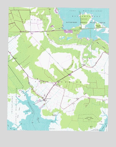
Swanquarter, NC USGS Topographic Map
Click on map above to begin viewing in our Map Viewer.

This topographic map contains these locations and features:
Feature Name Type Latitude Longitude GNIS ID View Map
Bell IslandAreaN35.3941°W76.3671°1003083View Map
Buck RidgeRidgeN35.4402°W76.2974°982113View Map
Calvary ChurchChurchN35.4032°W76.2935°982446View Map
Cowpen CreekBayN35.3941°W76.3488°983659View Map
Cowpen PointCapeN35.3924°W76.3449°983663View Map
Great IslandIslandN35.4885°W76.2783°986024View Map
Heron Bay IslandIslandN35.4813°W76.2627°986649View Map
Hyde Correctional InstitutionBuildingN35.4948°W76.3343°2769856View Map
Hyde County Emergency Medical ServicesBuildingN35.4208°W76.3189°2720581View Map
Hyde County Schools Administrative Central OfficeBuildingN35.4107°W76.3283°1003079View Map
Hyde County Sheriff's OfficeBuildingN35.4213°W76.3198°2130895View Map
Jobs ChapelChurchN35.4213°W76.3146°987617View Map
Judith MarshSwampN35.4086°W76.3669°987804View Map
Long PointCapeN35.3871°W76.3355°988987View Map
Oyster ChurchChurchN35.3843°W76.3227°991765View Map
Oyster Creek LandingPopulated PlaceN35.3907°W76.3146°1021774View Map
Piney Grove ChurchChurchN35.4163°W76.3438°992348View Map
Rattlesnake CreekStreamN35.3816°W76.2555°993050View Map
Rose Bay CanalCanalN35.4754°W76.3446°993684View Map
Rose Bay SchoolSchoolN35.4477°W76.3669°993686View Map
Sandy PointCapeN35.3757°W76.3183°994307View Map
Shingle CreekStreamN35.4129°W76.3519°994725View Map
Swan Quarter Census Designated PlaceCensusN35.4109°W76.3251°2584331View Map
Swan Quarter Volunteer Fire DepartmentBuildingN35.4061°W76.3286°2638159View Map
SwanquarterPopulated PlaceN35.4063°W76.3291°1022864View Map
Swanquarter Post OfficePost OfficeN35.4215°W76.3173°2774364View Map
Swanquarter SchoolSchoolN35.4221°W76.3160°995764View Map
Swindell ForkPopulated PlaceN35.4421°W76.2794°1006386View Map
Tapping HillSummitN35.4763°W76.2908°1022880View Map
The HauloverCanalN35.3793°W76.3602°995980View Map
Tiny Oak ForkPopulated PlaceN35.4068°W76.2880°996117View Map
Tiny Oak SchoolSchoolN35.4071°W76.2563°996118View Map

Note: Coordinates in the location and feature list above are referenced to NAD83 datum.


Copyright (C) 2008-2024 Ryan Niemi / Sunset Dynamics ... All Rights Reserved