TopoQuest Logo
Do you find TopoQuest useful?
Help keep TopoQuest running and adding new maps/features by donating!
Bitcoin:  19c7KJd3qBynnjoSw5npx9KScwjBe4ifkT
Litecoin:  LXs6TkuXGGXo1vDsWCkWVdjQX94eUKd6ui
Home View Maps Find Maps Find Places Resources & Links


Sunburg, Minnesota Topographic Map

USGS Map Title: Sunburg, MN
USGS Map MRC: 45095C2
DRG (GeoTIFF) Download: o45095c2.tif


Neighboring USGS Topographic Map Quads:


  Lake Simon, MN  
45095D3
 

  Lake Johanna, MN  
45095D2
 

  Belgrade, MN  
45095D1
 

  De Graff SE, MN  
45095C3
 

  Sunburg, MN  
45095C2
 

  Mount Tom, MN  
45095C1
 

  Kerkhoven, MN  
45095B3
 

  Pennock, MN  
45095B2
 

  Solomon Lake, MN  
45095B1


Map MRC Location:

N46°
W96°
N46°
W95°
H8 H7 H6 H5 H4 H3 H2 H1
G8 G7 G6 G5 G4 G3 G2 G1
F8 F7 F6 F5 F4 F3 F2 F1
E8 E7 E6 E5 E4 E3 E2 E1
D8 D7 D6 D5 D4 D3 D2 D1
C8 C7 C6 C5 C4 C3 C2 C1
B8 B7 B6 B5 B4 B3 B2 B1
A8 A7 A6 A5 A4 A3 A2 A1
N45°
W96°
N45°
W95°

Sunburg, MN USGS 1:24K Topographic Map Preview:
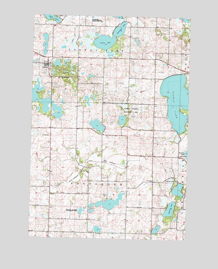
Sunburg, MN USGS Topographic Map
Click on map above to begin viewing in our Map Viewer.

This topographic map contains these locations and features:
Feature Name Type Latitude Longitude GNIS ID View Map
Blaamyhre LakeLakeN45.3627°W95.1892°640202View Map
Church of God CemeteryCemeteryN45.2680°W95.1623°2067743View Map
City of SunburgCivilN45.3476°W95.2400°2396005View Map
County Ditch Number FifteenCanalN45.3658°W95.2181°641697View Map
County Ditch Number TwentynineCanalN45.3352°W95.1706°641914View Map
County Ditch Number TwentysevenCanalN45.2927°W95.1975°641887View Map
East Norway Lake Lutheran CemeteryCemeteryN45.2849°W95.1361°2067742View Map
East Norway Lake Lutheran ChurchChurchN45.2850°W95.1350°2067745View Map
First Lutheran CemeteryCemeteryN45.2970°W95.1316°2067758View Map
First Lutheran ChurchChurchN45.2969°W95.1309°643659View Map
Glesne LakeLakeN45.3627°W95.1892°644189View Map
Hefta LakeLakeN45.3748°W95.2379°644831View Map
Hope Lutheran ChurchChurchN45.3478°W95.2381°2067674View Map
Nannestad CemeteryCemeteryN45.2827°W95.1526°648423View Map
Norway LakePopulated PlaceN45.2836°W95.1350°654852View Map
Norway Lake Post Office (historical)Post OfficeN45.2836°W95.1347°2067635View Map
Oleander State Wildlife Management AreaParkN45.3744°W95.2089°648943View Map
Sand LakebedFlatN45.2827°W95.2161°651167View Map
SunburgPopulated PlaceN45.3477°W95.2384°652804View Map
Sunburg ChurchChurchN45.3744°W95.2309°652805View Map
Sunburg Community Bible ChurchChurchN45.3478°W95.2381°2067673View Map
Sunburg Fire DepartmentBuildingN45.3489°W95.2407°2067672View Map
Sunburg Free Lutheran Church CemeteryCemeteryN45.3741°W95.2305°2067747View Map
Sunburg LakeLakeN45.3281°W95.2466°2067669View Map
Sunburg Post OfficePost OfficeN45.3478°W95.2381°2067671View Map
Sunburg Wildlife Management AreaParkN45.3361°W95.2417°2067670View Map
Swenson LakeLakeN45.2670°W95.1381°652947View Map
Township of ArctanderCivilN45.2823°W95.1934°663450View Map
Township of Norway LakeCivilN45.3696°W95.1930°665180View Map
West Lake ChurchChurchN45.2869°W95.2039°653979View Map
West Lake Lutheran CemeteryCemeteryN45.2867°W95.2038°2067744View Map
West LakebedFlatN45.2930°W95.1878°653982View Map
West Norway Lake CemeteryCemeteryN45.3399°W95.2276°2067746View Map
West Norway Lake ChurchChurchN45.3402°W95.2275°653993View Map

Note: Coordinates in the location and feature list above are referenced to NAD83 datum.


Copyright (C) 2008-2024 Ryan Niemi / Sunset Dynamics ... All Rights Reserved