TopoQuest Logo
Do you find TopoQuest useful?
Help keep TopoQuest running and adding new maps/features by donating!
Bitcoin:  19c7KJd3qBynnjoSw5npx9KScwjBe4ifkT
Litecoin:  LXs6TkuXGGXo1vDsWCkWVdjQX94eUKd6ui
Home View Maps Find Maps Find Places Resources & Links


Strawberry Reservoir NE, Utah Topographic Map

USGS Map Title: Strawberry Reservoir NE, UT
USGS Map MRC: 40111B1
DRG (GeoTIFF) Download: o40111b1.tif


Neighboring USGS Topographic Map Quads:


  Co-op Creek, UT  
40111C2
 

  Jimmies Point, UT  
40111C1
 

  Raspberry Knoll, UT  
40110C8
 

  Strawberry Reservoir NW, UT  
40111B2
 

  Strawberry Reservoir NE, UT  
40111B1
 

  Deep Creek Canyon, UT  
40110B8
 

  Strawberry Reservoir SW, UT  
40111A2
 

  Strawberry Reservoir SE, UT  
40111A1
 

  Strawberry Peak, UT  
40110A8


Map MRC Location:

N41°
W112°
N41°
W111°
H8 H7 H6 H5 H4 H3 H2 H1
G8 G7 G6 G5 G4 G3 G2 G1
F8 F7 F6 F5 F4 F3 F2 F1
E8 E7 E6 E5 E4 E3 E2 E1
D8 D7 D6 D5 D4 D3 D2 D1
C8 C7 C6 C5 C4 C3 C2 C1
B8 B7 B6 B5 B4 B3 B2 B1
A8 A7 A6 A5 A4 A3 A2 A1
N40°
W112°
N40°
W111°

Strawberry Reservoir NE, UT USGS 1:24K Topographic Map Preview:
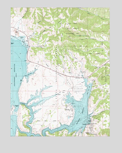
Strawberry Reservoir NE, UT USGS Topographic Map
Click on map above to begin viewing in our Map Viewer.

This topographic map contains these locations and features:
Feature Name Type Latitude Longitude GNIS ID View Map
Badger HollowValleyN40.1558°W111.1054°1438324View Map
Badger Point CampgroundLocaleN40.1313°W111.0371°1448101View Map
Chicken SpringSpringN40.1657°W111.0661°1439679View Map
Chipman CreekStreamN40.1352°W111.1202°1439697View Map
Coal CanyonValleyN40.2111°W111.1068°1439831View Map
Cow HollowValleyN40.2147°W111.1124°1440092View Map
Diving Rock Fisherman AccessLocaleN40.1494°W111.0257°1448345View Map
Green KnollSummitN40.1427°W111.0385°1441471View Map
Island MountainSummitN40.1333°W111.1088°1442067View Map
Pine HollowValleyN40.1430°W111.0307°1444392View Map
Road HollowValleyN40.1525°W111.1010°1445004View Map
Sage CreekStreamN40.1844°W111.1038°1445233View Map
Sage Creek Fisherman AccessLocaleN40.1819°W111.0249°1449021View Map
Soldier CreekStreamN40.1422°W111.0296°1445767View Map
Soldier Creek Bay Fisherman AccessLocaleN40.1791°W111.0274°1449016View Map
Soldier Creek CampgroundLocaleN40.1438°W111.0468°1449017View Map
Soldier Creek Campground Loop TrailTrailN40.1297°W111.0902°1449018View Map
Soldier Creek DamDamN40.1366°W111.0271°1447831View Map
Soldier Creek Dam Day Use AreaParkN40.1366°W111.0296°1449019View Map
Soldier Creek OverlookLocaleN40.1400°W111.0229°1449022View Map
Soldier Creek Recreation ComplexParkN40.1438°W111.0468°1449020View Map
Soldier Creek ReservoirReservoirN40.1731°W111.1232°1455519View Map
Soldier SpringsSpringN40.1826°W111.0410°1445772View Map
Square Top MountainSummitN40.2183°W111.0602°1446065View Map
Stinking SpringsSpringN40.1380°W111.0404°1446152View Map
Strawberry Dam (historical)DamN40.1569°W111.1127°1449075View Map
Strawberry River Day Use AreaParkN40.1283°W111.0254°1449076View Map
The NarrowsValleyN40.1558°W111.1063°1446482View Map
Trout CreekStreamN40.2166°W111.1149°1446738View Map
Uintah and Ouray DivisionCivilN40.2398°W111.0549°1939428View Map
Water Hollow TunnelCanalN40.2335°W111.0690°1454941View Map
West Portal Fisherman AccessLocaleN40.2150°W111.1110°1449173View Map
West Portal Water Hollow TunnelTunnelN40.2158°W111.1091°1454946View Map
Windy RidgeRidgeN40.1863°W111.0610°1447474View Map

Note: Coordinates in the location and feature list above are referenced to NAD83 datum.


Copyright (C) 2008-2024 Ryan Niemi / Sunset Dynamics ... All Rights Reserved