TopoQuest Logo
Do you find TopoQuest useful?
Help keep TopoQuest running and adding new maps/features by donating!
Bitcoin:  19c7KJd3qBynnjoSw5npx9KScwjBe4ifkT
Litecoin:  LXs6TkuXGGXo1vDsWCkWVdjQX94eUKd6ui
Home View Maps Find Maps Find Places Resources & Links


Stimson Hill, Washington Topographic Map

USGS Map Title: Stimson Hill, WA
USGS Map MRC: 48122C1
DRG (GeoTIFF) Download: o48122c1.tif


Neighboring USGS Topographic Map Quads:


  Sedro-Woolley South, WA  
48122D2
 

  Haystack Mountain, WA  
48122D1
 

  Day Lake, WA  
48121D8
 

  McMurray, WA  
48122C2
 

  Stimson Hill, WA  
48122C1
 

  Oso, WA  
48121C8
 

  Arlington West, WA  
48122B2
 

  Arlington East, WA  
48122B1
 

  Riley Lake, WA  
48121B8


Map MRC Location:

N49°
W123°
N49°
W122°
H8 H7 H6 H5 H4 H3 H2 H1
G8 G7 G6 G5 G4 G3 G2 G1
F8 F7 F6 F5 F4 F3 F2 F1
E8 E7 E6 E5 E4 E3 E2 E1
D8 D7 D6 D5 D4 D3 D2 D1
C8 C7 C6 C5 C4 C3 C2 C1
B8 B7 B6 B5 B4 B3 B2 B1
A8 A7 A6 A5 A4 A3 A2 A1
N48°
W123°
N48°
W122°

Stimson Hill, WA USGS 1:24K Topographic Map Preview:
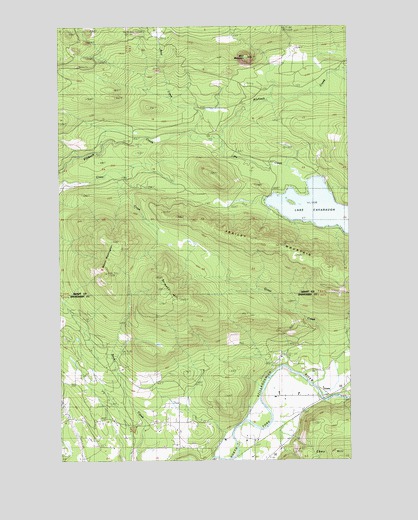
Stimson Hill, WA USGS Topographic Map
Click on map above to begin viewing in our Map Viewer.

This topographic map contains these locations and features:
Feature Name Type Latitude Longitude GNIS ID View Map
Alexander TrailTrailN48.2879°W122.0485°1515801View Map
Bald MountainSummitN48.3662°W122.0449°1516084View Map
Bear CreekStreamN48.3440°W122.0696°1516242View Map
Bryant HillSummitN48.3040°W122.1063°1527835View Map
CiceroPopulated PlaceN48.2687°W122.0104°1517779View Map
Frailey Mountain Truck TrailTrailN48.3087°W122.0335°1519763View Map
Frailey PondsLakeN48.3137°W122.0699°1530493View Map
Grandview Recreation CenterParkN48.2504°W122.0688°1520204View Map
Grant CreekStreamN48.2715°W122.0176°1528938View Map
Lake CavanaughPopulated PlaceN48.3262°W122.0210°1852944View Map
Lake CavanaughLakeN48.3208°W122.0094°1517510View Map
Lake Cavanaugh Census Designated PlaceCensusN48.3225°W122.0122°2408535View Map
Lake CreekStreamN48.3426°W122.0582°1521838View Map
Mount CavanaughSummitN48.3323°W122.0613°1797407View Map
Mount Washington TrailTrailN48.3029°W122.0993°1523434View Map
North County Fire / Emergency Medical Services Station 92 GrandviewBuildingN48.2617°W122.0745°2619548View Map
North Fork DairyLocaleN48.2692°W122.0233°2705988View Map
Spar Tree TrailTrailN48.3043°W122.0610°1526332View Map
Stimson HillSummitN48.3020°W122.0832°1526573View Map
Strawder DairyLocaleN48.2564°W122.0406°2705846View Map
Williams AirpatchAirportN48.2707°W122.0193°1533666View Map

Note: Coordinates in the location and feature list above are referenced to NAD83 datum.


Copyright (C) 2008-2024 Ryan Niemi / Sunset Dynamics ... All Rights Reserved