TopoQuest Logo
Do you find TopoQuest useful?
Help keep TopoQuest running and adding new maps/features by donating!
Bitcoin:  19c7KJd3qBynnjoSw5npx9KScwjBe4ifkT
Litecoin:  LXs6TkuXGGXo1vDsWCkWVdjQX94eUKd6ui
Home View Maps Find Maps Find Places Resources & Links


Stiggins Lake, Alabama Topographic Map

USGS Map Title: Stiggins Lake, AL
USGS Map MRC: 31087A8
DRG (GeoTIFF) Download: o31087a8.tif


Neighboring USGS Topographic Map Quads:


  Calvert, AL  
31088B1
 

  Bilbo Island, AL  
31087B8
 

  Tensaw, AL  
31087B7
 

  Mount Vernon, AL  
31088A1
 

  Stiggins Lake, AL  
31087A8
 

  Vaughn, AL  
31087A7
 

  Creola, AL  
30088H1
 

  The Basin, AL  
30087H8
 

  Bay Minette North, AL  
30087H7


Map MRC Location:

N32°
W88°
N32°
W87°
H8 H7 H6 H5 H4 H3 H2 H1
G8 G7 G6 G5 G4 G3 G2 G1
F8 F7 F6 F5 F4 F3 F2 F1
E8 E7 E6 E5 E4 E3 E2 E1
D8 D7 D6 D5 D4 D3 D2 D1
C8 C7 C6 C5 C4 C3 C2 C1
B8 B7 B6 B5 B4 B3 B2 B1
A8 A7 A6 A5 A4 A3 A2 A1
N31°
W88°
N31°
W87°

Stiggins Lake, AL USGS 1:24K Topographic Map Preview:
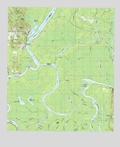
Stiggins Lake, AL USGS Topographic Map
Click on map above to begin viewing in our Map Viewer.

This topographic map contains these locations and features:
Feature Name Type Latitude Longitude GNIS ID View Map
Aikin IslandIslandN31.0174°W87.9153°112945View Map
Apostolic Overcoming Holiness Church of GodChurchN31.1025°W87.9901°1730008View Map
Bayou JessamineGutN31.0066°W87.9139°113603View Map
Bayou MatcheGutN31.0068°W87.9753°158776View Map
Bayou TallapoosaGutN31.0446°W87.9289°113613View Map
Bear CreekGutN31.1066°W87.8961°113645View Map
Beaver Dam CreekStreamN31.1093°W87.9953°143134View Map
Belsaw SchoolSchoolN31.0909°W87.9977°143141View Map
Big Beaver CreekGutN31.0960°W87.8833°114221View Map
Big Chippewa LakeLakeN31.0304°W87.9836°158784View Map
Borrow CreekStreamN31.1060°W87.9686°112840View Map
Briar LakeLakeN31.0011°W87.8905°114881View Map
Bryant LandingLocaleN31.0441°W87.8761°156124View Map
Canal IslandIslandN31.0905°W87.8942°115529View Map
Cedar CreekStreamN31.0560°W87.9983°115744View Map
Church of God PentecostalChurchN31.1004°W87.9824°1729977View Map
Clearwater LakeLakeN31.1099°W87.9206°116243View Map
Dabney CreekStreamN31.1171°W87.9878°117008View Map
David LakeLakeN31.1010°W87.9706°117093View Map
Deadlake IslandIslandN31.0482°W87.9097°117164View Map
Devils BendBendN31.0268°W87.9247°117249View Map
Douglas LakeLakeN31.0582°W87.8906°117430View Map
First ChurchChurchN31.0957°W87.9894°1729970View Map
Fisher IslandIslandN31.0077°W87.9078°118314View Map
Flat PointCapeN31.0530°W87.9975°143344View Map
Fort StoddardPopulated PlaceN31.0999°W87.9792°169330View Map
Free ChurchChurchN31.1063°W87.9903°1729974View Map
Globe CreekGutN31.1113°W87.8769°119049View Map
Gumbo LakeSwampN31.0946°W87.9428°119496View Map
Jose Creb BayouGutN31.0093°W87.9833°121056View Map
Lake SloughGutN31.0718°W87.9444°121326View Map
Larry IslandIslandN31.0127°W87.8989°121401View Map
Little Chippewa LakeLakeN31.0288°W87.9721°158860View Map
Little LakeLakeN31.0778°W87.9074°121811View Map
Louis LakeLakeN31.0671°W87.9761°122053View Map
Mary Ida PointCapeN31.0216°W87.9978°143512View Map
Meahers LandingLocaleN31.0571°W87.9847°143524View Map
Minnow SloughGutN31.0757°W87.9328°122874View Map
Mobile County Health Department Mount Vernon ClinicHospitalN31.0984°W87.9908°2579552View Map
Morning Star ChurchChurchN31.0924°W87.9922°123059View Map
Morningstar CemeteryCemeteryN31.0949°W87.9940°2579321View Map
Mount Olive Primitive Baptist ChurchChurchN31.0927°W87.9922°143574View Map
Mount Vernon Community CenterBuildingN31.0986°W87.9906°2579553View Map
Mount Vernon Crossing (historical)LocaleN31.0982°W87.9661°134643View Map
Movico Oil FieldOilfieldN31.0557°W87.9758°151197View Map
Napp LakeLakeN31.1027°W87.9003°123637View Map
Old Fort Stoddard Mount Vernon LandingLocaleN31.0893°W87.9786°156833View Map
Pine Grove ChurchChurchN31.0907°W87.9933°143657View Map
Proctor CreekGutN31.0788°W87.8792°125296View Map
Promise Land LandingLocaleN31.0635°W87.9753°143681View Map
Rice CreekStreamN31.0118°W87.8875°125596View Map
Rice Creek LandingLocaleN31.0155°W87.8800°156962View Map
Richardson IslandIslandN31.0196°W87.8925°125613View Map
Robinson IslandIslandN31.0299°W87.9064°125729View Map
Shephard LandingLocaleN31.0871°W87.9744°134705View Map
Sheppard LakeLakeN31.1097°W87.9694°126695View Map
Sheppard LandingLocaleN31.1132°W87.9814°143798View Map
Sisters CreekStreamN31.0005°W87.9867°126910View Map
Stiggins LakeLakeN31.0889°W87.9197°127394View Map
Tensaw LakeLakeN31.0480°W87.8875°127764View Map
Union ChurchChurchN31.0018°W87.8764°128280View Map

Note: Coordinates in the location and feature list above are referenced to NAD83 datum.


Copyright (C) 2008-2024 Ryan Niemi / Sunset Dynamics ... All Rights Reserved