TopoQuest Logo
Do you find TopoQuest useful?
Help keep TopoQuest running and adding new maps/features by donating!
Bitcoin:  19c7KJd3qBynnjoSw5npx9KScwjBe4ifkT
Litecoin:  LXs6TkuXGGXo1vDsWCkWVdjQX94eUKd6ui
Home View Maps Find Maps Find Places Resources & Links


Sterling, Pennsylvania Topographic Map

USGS Map Title: Sterling, PA
USGS Map MRC: 41075C4
DRG (GeoTIFF) Download: o41075c4.tif


Neighboring USGS Topographic Map Quads:


  Olyphant, PA  
41075D5
 

  Lake Ariel, PA  
41075D4
 

  Lakeville, PA  
41075D3
 

  Moscow, PA  
41075C5
 

  Sterling, PA  
41075C4
 

  Newfoundland, PA  
41075C3
 

  Thornhurst, PA  
41075B5
 

  Tobyhanna, PA  
41075B4
 

  Buck Hill Falls, PA  
41075B3


Map MRC Location:

N42°
W76°
N42°
W75°
H8 H7 H6 H5 H4 H3 H2 H1
G8 G7 G6 G5 G4 G3 G2 G1
F8 F7 F6 F5 F4 F3 F2 F1
E8 E7 E6 E5 E4 E3 E2 E1
D8 D7 D6 D5 D4 D3 D2 D1
C8 C7 C6 C5 C4 C3 C2 C1
B8 B7 B6 B5 B4 B3 B2 B1
A8 A7 A6 A5 A4 A3 A2 A1
N41°
W76°
N41°
W75°

Sterling, PA USGS 1:24K Topographic Map Preview:
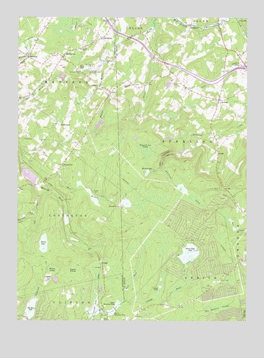
Sterling, PA USGS Topographic Map
Click on map above to begin viewing in our Map Viewer.

This topographic map contains these locations and features:
Feature Name Type Latitude Longitude GNIS ID View Map
AberdeenPopulated PlaceN41.3587°W75.4938°1168027View Map
Air Haven AirportAirportN41.3501°W75.4830°1194217View Map
Bear Branch School (historical)SchoolN41.3434°W75.4930°1197818View Map
Big Bass LakeReservoirN41.2551°W75.4920°1195412View Map
Big Bass LakePopulated PlaceN41.2538°W75.4764°2633441View Map
Big Bass Lake Census Designated PlaceCensusN41.2525°W75.4795°2633330View Map
Big Bass Lake DamDamN41.2515°W75.4949°1195413View Map
Big Sampson SwampSwampN41.2560°W75.3889°1169582View Map
BloomingtonPopulated PlaceN41.3306°W75.4766°1169856View Map
CallapoosePopulated PlaceN41.3715°W75.4052°1170897View Map
Crystal LakeReservoirN41.2734°W75.4213°1195430View Map
Crystal Lake DamDamN41.2734°W75.4213°1195431View Map
Drinker SchoolSchoolN41.3620°W75.4655°1173482View Map
Eagle LakePopulated PlaceN41.2845°W75.4877°2633439View Map
Eagle Lake Census Designated PlaceCensusN41.2826°W75.4795°2633364View Map
East Branch Roaring BrookStreamN41.3079°W75.4885°1173767View Map
Emerson RunStreamN41.2937°W75.4896°1174218View Map
English SwampSwampN41.2711°W75.4688°1174266View Map
FreytownPopulated PlaceN41.2973°W75.4452°1203633View Map
Freytown CemeteryCemeteryN41.3026°W75.4566°1175238View Map
Frogtown School (historical)SchoolN41.3443°W75.4494°1197819View Map
Gas HollowValleyN41.3198°W75.4130°1175473View Map
Haas PondReservoirN41.3533°W75.4650°1176342View Map
Henry LakeReservoirN41.2817°W75.4853°1198073View Map
Hollister DamDamN41.3134°W75.4963°1195467View Map
Hollister ReservoirReservoirN41.3098°W75.4930°1195468View Map
JerichoPopulated PlaceN41.3193°W75.3905°1203894View Map
Jericho CemeteryCemeteryN41.3112°W75.3910°1178048View Map
JubileePopulated PlaceN41.3470°W75.4557°1178179View Map
Kopicki DamDamN41.3434°W75.4596°1208985View Map
Lake HenryReservoirN41.2851°W75.4880°1195440View Map
Lake Henry DamDamN41.2851°W75.4880°1195441View Map
Lake RunStreamN41.3034°W75.4871°1178786View Map
Larsen DamDamN41.2548°W75.4563°1195410View Map
Larsen LakeLakeN41.2552°W75.4567°1195411View Map
LehighPopulated PlaceN41.2745°W75.4538°1179153View Map
Lehigh PondLakeN41.2641°W75.4217°1179158View Map
Lower DamDamN41.2570°W75.4502°1208964View Map
Lower Klondike DamDamN41.2534°W75.4496°1195416View Map
Lower Klondike PondReservoirN41.2535°W75.4487°1180017View Map
MadisonvillePopulated PlaceN41.3587°W75.4752°1180187View Map
Madisonville Independent Fire Company Station 56BuildingN41.3624°W75.4667°2653074View Map
Memory LakeReservoirN41.3111°W75.4289°1180920View Map
Pocono Peak LakeReservoirN41.2779°W75.4059°1184154View Map
Pocono SpringsPopulated PlaceN41.2745°W75.4113°1212903View Map
Pocono Springs Census Designated PlaceCensusN41.2797°W75.4017°2633409View Map
Potter CreekStreamN41.3643°W75.4441°1184335View Map
QuicktownPopulated PlaceN41.3665°W75.4535°1184555View Map
Robinson DamDamN41.3634°W75.4530°1195502View Map
Robinson LakeReservoirN41.3634°W75.4530°1195501View Map
Spring Hill AirportAirportN41.3474°W75.4159°1194215View Map
SterlingPopulated PlaceN41.3412°W75.3899°1188612View Map
Sterling Post OfficePost OfficeN41.3431°W75.3895°2772991View Map
Stevens CreekStreamN41.3701°W75.4257°1188625View Map
Tamarack DamDamN41.2518°W75.4949°1208716View Map
Thousand Acre SwampSwampN41.3203°W75.4292°1189535View Map
Township of LehighCivilN41.2542°W75.4204°1217222View Map
Township of MadisonCivilN41.3518°W75.4791°1216603View Map
Township of SterlingCivilN41.3285°W75.4030°1217230View Map
TurnersvillePopulated PlaceN41.3143°W75.4755°1189963View Map
Upper Klondike PondReservoirN41.2551°W75.4466°1190235View Map
Upper Wilcox PondLakeN41.3426°W75.4619°1202079View Map
Webster CreekStreamN41.3456°W75.4294°1190758View Map
West Fork Lehigh RiverStreamN41.2584°W75.4407°1191027View Map
Wildcat SwampSwampN41.2711°W75.4798°1191424View Map

Note: Coordinates in the location and feature list above are referenced to NAD83 datum.


Copyright (C) 2008-2024 Ryan Niemi / Sunset Dynamics ... All Rights Reserved