TopoQuest Logo
Do you find TopoQuest useful?
Help keep TopoQuest running and adding new maps/features by donating!
Bitcoin:  19c7KJd3qBynnjoSw5npx9KScwjBe4ifkT
Litecoin:  LXs6TkuXGGXo1vDsWCkWVdjQX94eUKd6ui
Home View Maps Find Maps Find Places Resources & Links


Stanford, Indiana Topographic Map

USGS Map Title: Stanford, IN
USGS Map MRC: 39086A6
DRG (GeoTIFF) Download: o39086a6.tif


Neighboring USGS Topographic Map Quads:


  Freedom, IN  
39086B7
 

  Whitehall, IN  
39086B6
 

  Bloomington, IN  
39086B5
 

  Solsberry, IN  
39086A7
 

  Stanford, IN  
39086A6
 

  Clear Creek, IN  
39086A5
 

  Koleen, IN  
38086H7
 

  Owensburg, IN  
38086H6
 

  Oolitic, IN  
38086H5


Map MRC Location:

N40°
W87°
N40°
W86°
H8 H7 H6 H5 H4 H3 H2 H1
G8 G7 G6 G5 G4 G3 G2 G1
F8 F7 F6 F5 F4 F3 F2 F1
E8 E7 E6 E5 E4 E3 E2 E1
D8 D7 D6 D5 D4 D3 D2 D1
C8 C7 C6 C5 C4 C3 C2 C1
B8 B7 B6 B5 B4 B3 B2 B1
A8 A7 A6 A5 A4 A3 A2 A1
N39°
W87°
N39°
W86°

Stanford, IN USGS 1:24K Topographic Map Preview:
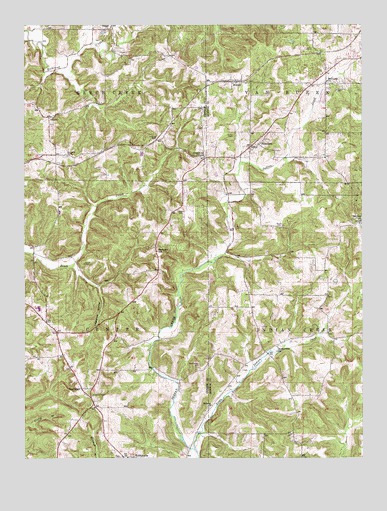
Stanford, IN USGS Topographic Map
Click on map above to begin viewing in our Map Viewer.

This topographic map contains these locations and features:
Feature Name Type Latitude Longitude GNIS ID View Map
BuenavistaPopulated PlaceN39.0331°W86.6556°452229View Map
Buenavista ChurchChurchN39.0309°W86.6567°431767View Map
Burch CemeteryCemeteryN39.0670°W86.6544°431821View Map
Burch CemeteryCemeteryN39.0564°W86.7283°431822View Map
Carmichael CemeteryCemeteryN39.0262°W86.6856°432152View Map
Center Township Volunteer Fire DepartmentBuildingN39.0264°W86.7343°2626196View Map
CincinnatiPopulated PlaceN39.0200°W86.7289°432522View Map
Edwards CemeteryCemeteryN39.0920°W86.7011°434029View Map
ElwrenPopulated PlaceN39.1087°W86.6697°434146View Map
Greene County ChapelChurchN39.0870°W86.6833°435394View Map
Greene County Chapel CemeteryCemeteryN39.0871°W86.6829°2725299View Map
Harmony CemeteryCemeteryN39.1059°W86.6344°435747View Map
Harmony ChurchChurchN39.1089°W86.6381°435748View Map
Hebron ChurchChurchN39.0153°W86.6808°435966View Map
Keller CemeteryCemeteryN39.0928°W86.6728°437208View Map
Lawrence HollowValleyN39.0493°W86.7226°437669View Map
Little Indian CreekStreamN39.0025°W86.6872°438079View Map
Mount Zion ChurchChurchN39.0684°W86.6253°439759View Map
Sanbourn SchoolSchoolN39.0598°W86.7011°442958View Map
Solsberry CemeteryCemeteryN39.0873°W86.7342°443762View Map
Sparks CemeteryCemeteryN39.0712°W86.6931°443908View Map
StanfordPopulated PlaceN39.0898°W86.6667°444059View Map
Township of Indian CreekCivilN39.0357°W86.6279°453426View Map
Township of Van BurenCivilN39.1222°W86.6280°453950View Map
Union ChurchChurchN39.1234°W86.7189°445099View Map
Van Buren Township Fire Department Station 19BuildingN39.0895°W86.6653°2626314View Map

Note: Coordinates in the location and feature list above are referenced to NAD83 datum.


Copyright (C) 2008-2024 Ryan Niemi / Sunset Dynamics ... All Rights Reserved