TopoQuest Logo
Do you find TopoQuest useful?
Help keep TopoQuest running and adding new maps/features by donating!
Bitcoin:  19c7KJd3qBynnjoSw5npx9KScwjBe4ifkT
Litecoin:  LXs6TkuXGGXo1vDsWCkWVdjQX94eUKd6ui
Home View Maps Find Maps Find Places Resources & Links


Spanish Fork Peak, Utah Topographic Map

USGS Map Title: Spanish Fork Peak, UT
USGS Map MRC: 40111A5
DRG (GeoTIFF) Download: o40111a5.tif


Neighboring USGS Topographic Map Quads:


  Provo, UT  
40111B6
 

  Springville, UT  
40111B5
 

  Granger Mountain, UT  
40111B4
 

  Spanish Fork, UT  
40111A6
 

  Spanish Fork Peak, UT  
40111A5
 

  Billies Mountain, UT  
40111A4
 

  Payson Lakes, UT  
39111H6
 

  Birdseye, UT  
39111H5
 

  Thistle, UT  
39111H4


Map MRC Location:

N41°
W112°
N41°
W111°
H8 H7 H6 H5 H4 H3 H2 H1
G8 G7 G6 G5 G4 G3 G2 G1
F8 F7 F6 F5 F4 F3 F2 F1
E8 E7 E6 E5 E4 E3 E2 E1
D8 D7 D6 D5 D4 D3 D2 D1
C8 C7 C6 C5 C4 C3 C2 C1
B8 B7 B6 B5 B4 B3 B2 B1
A8 A7 A6 A5 A4 A3 A2 A1
N40°
W112°
N40°
W111°

Spanish Fork Peak, UT USGS 1:24K Topographic Map Preview:
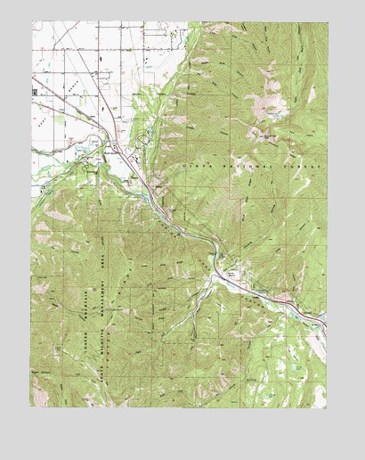
Spanish Fork Peak, UT USGS Topographic Map
Click on map above to begin viewing in our Map Viewer.

This topographic map contains these locations and features:
Feature Name Type Latitude Longitude GNIS ID View Map
Big Slide CanyonValleyN40.1100°W111.5685°1438729View Map
Big SpringsSpringN40.0092°W111.5348°1438747View Map
CastillaPopulated PlaceN40.0355°W111.5260°1439508View Map
Castilla SpringsSpringN40.0371°W111.5291°1439509View Map
City of MapletonCivilN40.1186°W111.5735°2411029View Map
Cold SpringsSpringN40.0486°W111.5466°1439878View Map
Covered Bridge CanyonPopulated PlaceN40.0358°W111.5533°2708039View Map
Creer HollowValleyN40.0338°W111.5163°1440145View Map
Crowd CanyonValleyN40.1019°W111.5771°1440174View Map
Diamond ForkStreamN40.0266°W111.5049°1440445View Map
Dominguez HillSummitN40.0763°W111.5966°1448347View Map
Dream MineMineN40.0427°W111.6233°1440551View Map
Dry Diamond RidgeRidgeN40.0816°W111.5119°1440610View Map
East BenchBenchN40.1027°W111.6160°1440765View Map
East Bench CanalCanalN40.0977°W111.6138°1440766View Map
Flat CanyonValleyN40.0527°W111.6241°1441120View Map
GomexPopulated PlaceN40.0744°W111.5791°1441364View Map
Green FlatFlatN40.0325°W111.5446°1441466View Map
Joes CanyonValleyN40.0413°W111.5357°1442162View Map
KTMP-FM (Spanish Fork)TowerN40.0630°W111.6088°1455786View Map
Left Fork Maple CanyonValleyN40.0097°W111.6158°1442514View Map
Left Fork Pole CanyonValleyN40.0305°W111.5571°1442519View Map
Left Fork Shurtz CanyonValleyN40.0016°W111.5532°1442529View Map
Little Slide CanyonValleyN40.1216°W111.5560°1442781View Map
Loafer Mountain Wildlife Management AreaParkN40.0244°W111.5933°1448618View Map
Loafer RidgeRidgeN40.0147°W111.5927°1442827View Map
Lone Pine GulchValleyN40.0422°W111.5491°1442876View Map
Lone Pine RidgeRidgeN40.0472°W111.5674°1442877View Map
Maple Canyon LakeLakeN40.0948°W111.5203°1443153View Map
Mapleton LateralCanalN40.1100°W111.5758°1454581View Map
Mapleton SidingLocaleN40.1100°W111.6019°1443190View Map
Middle Slide CanyonValleyN40.1175°W111.5605°1443378View Map
Moark JunctionPopulated PlaceN40.0827°W111.5883°1443535View Map
North BenchBenchN40.0433°W111.5388°1443847View Map
Old Spanish MineMineN40.0322°W111.5921°1444077View Map
Pace HollowBasinN40.0888°W111.5119°1444147View Map
Pole CanyonValleyN40.0416°W111.5469°1444519View Map
Power CanalCanalN40.0691°W111.5819°1451111View Map
Right Fork Maple CanyonValleyN40.0097°W111.6155°1444938View Map
Right Fork Pole CanyonValleyN40.0302°W111.5571°1444948View Map
Right Fork Shurtz CanyonValleyN40.0016°W111.5532°1444956View Map
Shurtz CanyonValleyN40.0325°W111.5185°1445565View Map
Shurtz LakeLakeN40.0132°W111.5145°1445566View Map
Snell CanyonValleyN40.0780°W111.5969°1445727View Map
Spanish Fork CanyonValleyN40.0838°W111.5960°1445947View Map
Spanish Fork PeakSummitN40.0883°W111.5277°1445948View Map
Sterling HollowValleyN40.0433°W111.5444°1446136View Map
Strongs LakeLakeN40.0041°W111.5255°1446200View Map
SutroPopulated PlaceN40.0919°W111.5971°1446264View Map
The Church of Jesus Christ of Latter Day SaintsChurchN40.1000°W111.6249°1450716View Map
The PastureFlatN40.0180°W111.5144°1446487View Map
Thurber CanyonValleyN40.0402°W111.5491°1446582View Map
Thurber RidgeRidgeN40.0291°W111.5730°1446584View Map
Wind Rock RidgeRidgeN40.0694°W111.5338°1447465View Map

Note: Coordinates in the location and feature list above are referenced to NAD83 datum.


Copyright (C) 2008-2024 Ryan Niemi / Sunset Dynamics ... All Rights Reserved