TopoQuest Logo
Do you find TopoQuest useful?
Help keep TopoQuest running and adding new maps/features by donating!
Bitcoin:  19c7KJd3qBynnjoSw5npx9KScwjBe4ifkT
Litecoin:  LXs6TkuXGGXo1vDsWCkWVdjQX94eUKd6ui
Home View Maps Find Maps Find Places Resources & Links


Somerset, Indiana Topographic Map

USGS Map Title: Somerset, IN
USGS Map MRC: 40085F7
DRG (GeoTIFF) Download: o40085f7.tif


Neighboring USGS Topographic Map Quads:


  Richvalley, IN  
40085G8
 

  Wabash, IN  
40085G7
 

  Lagro, IN  
40085G6
 

  Peoria, IN  
40085F8
 

  Somerset, IN  
40085F7
 

  La Fontaine, IN  
40085F6
 

  Amboy, IN  
40085E8
 

  Sweetser, IN  
40085E7
 

  Marion, IN  
40085E6


Map MRC Location:

N41°
W86°
N41°
W85°
H8 H7 H6 H5 H4 H3 H2 H1
G8 G7 G6 G5 G4 G3 G2 G1
F8 F7 F6 F5 F4 F3 F2 F1
E8 E7 E6 E5 E4 E3 E2 E1
D8 D7 D6 D5 D4 D3 D2 D1
C8 C7 C6 C5 C4 C3 C2 C1
B8 B7 B6 B5 B4 B3 B2 B1
A8 A7 A6 A5 A4 A3 A2 A1
N40°
W86°
N40°
W85°

Somerset, IN USGS 1:24K Topographic Map Preview:
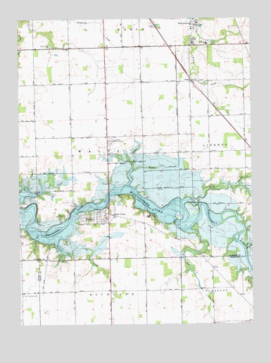
Somerset, IN USGS Topographic Map
Click on map above to begin viewing in our Map Viewer.

This topographic map contains these locations and features:
Feature Name Type Latitude Longitude GNIS ID View Map
Cart CreekStreamN40.6634°W85.7800°432182View Map
Converse - Somerset Fire DepartmentBuildingN40.6694°W85.8282°2701489View Map
Forked BranchStreamN40.6889°W85.8136°434674View Map
Goose CreekStreamN40.6787°W85.8694°435182View Map
Grant CreekStreamN40.6748°W85.7866°435320View Map
Hogback Ridge State Recreation AreaParkN40.6684°W85.8039°436297View Map
Latchum SchoolSchoolN40.7473°W85.7800°437638View Map
Lebanon ChurchChurchN40.7381°W85.8480°437722View Map
Metocinah CreekStreamN40.6562°W85.7536°439052View Map
Mississinewa Memorial CemeteryCemeteryN40.7003°W85.8261°439289View Map
Mount VernonPopulated PlaceN40.6695°W85.8242°439717View Map
Muddy BranchStreamN40.6823°W85.8167°439851View Map
Murphy CemeteryCemeteryN40.7386°W85.8574°438677View Map
Pearson Mill State Recreation AreaParkN40.6695°W85.8492°440962View Map
Pee Dee CreekStreamN40.6817°W85.7569°440971View Map
Reserve Number FourReserveN40.6584°W85.7958°446930View Map
Reserve Number ThreeReserveN40.6584°W85.7791°446929View Map
Reserve Number TwoReserveN40.6584°W85.7666°446928View Map
Rock RunStreamN40.6598°W85.8661°442209View Map
SomersetPopulated PlaceN40.6692°W85.8283°443764View Map
Somerset Census Designated PlaceCensusN40.6695°W85.8318°2631626View Map
Southwood Elementary SchoolSchoolN40.7398°W85.7736°443899View Map
Southwood Junior-Senior High SchoolSchoolN40.7400°W85.7814°443898View Map
Tenmile CreekStreamN40.6584°W85.8550°444636View Map
The HogbackRidgeN40.6720°W85.7814°444667View Map
Township of WaltzCivilN40.6948°W85.8647°453972View Map
TreatyPopulated PlaceN40.7245°W85.7825°444864View Map
White InstituteSchoolN40.7478°W85.7817°445943View Map

Note: Coordinates in the location and feature list above are referenced to NAD83 datum.


Copyright (C) 2008-2024 Ryan Niemi / Sunset Dynamics ... All Rights Reserved