TopoQuest Logo
Do you find TopoQuest useful?
Help keep TopoQuest running and adding new maps/features by donating!
Bitcoin:  19c7KJd3qBynnjoSw5npx9KScwjBe4ifkT
Litecoin:  LXs6TkuXGGXo1vDsWCkWVdjQX94eUKd6ui
Home View Maps Find Maps Find Places Resources & Links


Sodus Point, New York Topographic Map

USGS Map Title: Sodus Point, NY
USGS Map MRC: 43076C8
DRG (GeoTIFF) Download: o43076c8.tif


Neighboring USGS Topographic Map Quads:


  Salmon Creek, NY  
43077C1
 

  Sodus Point, NY  
43076C8
 

  North Wolcott, NY  
43076C7
 

  Sodus, NY  
43077B1
 

  Rose, NY  
43076B8
 

  Wolcott, NY  
43076B7


Map MRC Location:

N44°
W77°
N44°
W76°
H8 H7 H6 H5 H4 H3 H2 H1
G8 G7 G6 G5 G4 G3 G2 G1
F8 F7 F6 F5 F4 F3 F2 F1
E8 E7 E6 E5 E4 E3 E2 E1
D8 D7 D6 D5 D4 D3 D2 D1
C8 C7 C6 C5 C4 C3 C2 C1
B8 B7 B6 B5 B4 B3 B2 B1
A8 A7 A6 A5 A4 A3 A2 A1
N43°
W77°
N43°
W76°

Sodus Point, NY USGS 1:24K Topographic Map Preview:
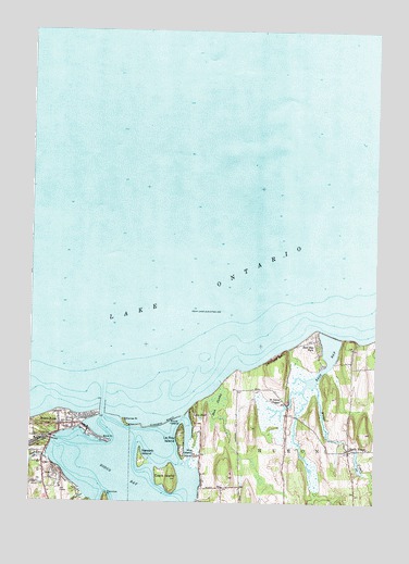
Sodus Point, NY USGS Topographic Map
Click on map above to begin viewing in our Map Viewer.

This topographic map contains these locations and features:
Feature Name Type Latitude Longitude GNIS ID View Map
Arneys MarinaLocaleN43.2615°W76.9944°973697View Map
Charles PointCapeN43.2717°W76.9658°946400View Map
Chimney BluffCliffN43.2890°W76.9108°946582View Map
Connellys CoveBayN43.2578°W76.9383°973648View Map
Crescent BeachBeachN43.2706°W76.9508°947736View Map
Eagle IslandIslandN43.2578°W76.9494°948922View Map
East BayBayN43.2825°W76.8966°948973View Map
East Bay ParkPopulated PlaceN43.2920°W76.8950°948977View Map
East Pier LightLocaleN43.2767°W76.9725°973647View Map
First CreekStreamN43.2623°W76.9930°950102View Map
Hog IslandIslandN43.2626°W76.9400°952944View Map
Knob IslandIslandN43.2709°W76.9489°954783View Map
Lake BluffPopulated PlaceN43.2726°W76.9414°954895View Map
Lake Bluff CampgroundLocaleN43.2583°W76.9209°2599575View Map
Le Roy IslandIslandN43.2681°W76.9450°955129View Map
Mudge CreekStreamN43.2812°W76.8964°970390View Map
Newark IslandIslandN43.2615°W76.9594°958487View Map
North HuronPopulated PlaceN43.2637°W76.8841°958827View Map
Root SwampSwampN43.2767°W76.9330°962886View Map
Saint Johns ChapelChurchN43.2773°W76.9091°963623View Map
Sand PointCapeN43.2662°W76.9716°964390View Map
School Number 13 (historical)SchoolN43.2519°W76.9931°2380862View Map
School Number 9 (historical)SchoolN43.2642°W76.8847°2380861View Map
Sills MarinaLocaleN43.2684°W76.9880°973646View Map
Skippers Landing MarinaLocaleN43.2540°W76.9366°973637View Map
Sodus BayLakeN43.2527°W76.9574°965620View Map
Sodus Bay MarinaLocaleN43.2673°W76.9786°973649View Map
Sodus Bay Yacht ClubLocaleN43.2678°W76.9464°973644View Map
Sodus Outer LightLocaleN43.2773°W76.9741°973650View Map
Sodus PointPopulated PlaceN43.2717°W76.9891°965624View Map
Sodus Point Fire DepartmentBuildingN43.2701°W76.9866°2701270View Map
Sodus Point LighthouseLocaleN43.2769°W76.9742°2380860View Map
Sodus Point Post OfficePost OfficeN43.2703°W76.9833°2599551View Map
Thornton PointCapeN43.2523°W76.9719°967438View Map
Thorpe VineyardLocaleN43.2894°W76.8983°2547497View Map
Village of Sodus PointCivilN43.2640°W76.9952°2391143View Map

Note: Coordinates in the location and feature list above are referenced to NAD83 datum.


Copyright (C) 2008-2024 Ryan Niemi / Sunset Dynamics ... All Rights Reserved